
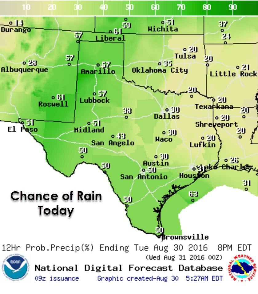
We’re starting off another morning wet across parts of the state as we head towards the end of August. Showers are moving northwest across the Texas Panhandle into western sections of the South Plains and south into the Permian Basin. More showers, some with heavy rain, are sitting on the Middle Texas Coast from Corpus Christi north to Seadrift, Port Lava, to Victoria and Inez. Scatterded showers and storms are once again expected to continue into the afternoon across. In terms of flash flooding/heavy rain risk we have two regions we’ll be watching today. The first is in the Texas Panhandle, West Texas, Permian Basin, and the Borderland where localized flooding will be possible with heavier showers. The second region is in the Middle Texas Coast and South Texas where moisture from a weak low pressure system offshore will help showers be efficient at producing locally heavy rain.
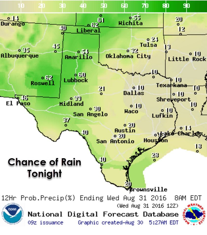
The best chance for getting wet today will be in the Texas Panhandle, West Texas, Permian Basin, Concho Valley, Borderland, Alpine Mountains, Southwest Texas, South-Central Texas, South Texas, the Rio Grande Valley, Middle Texas Coast, and in Southeast Texas. More isolated shower/storm activity, typical of summer afternoons, will be possible in Northwest Texas, the Big Country, North Texas, Central Texas, East Texas, Northeast Texas, and into the Brazos Valley. Activity will slowly move from southeast to northwest today thanks to the low pressure sitting in the western Gulf of Mexico. This low is not the same as Tropical Depression #9 located much closer to Florida. Rain chances will continue in western sections of Texas tonight with a localized heavy rain/flash flood risk.

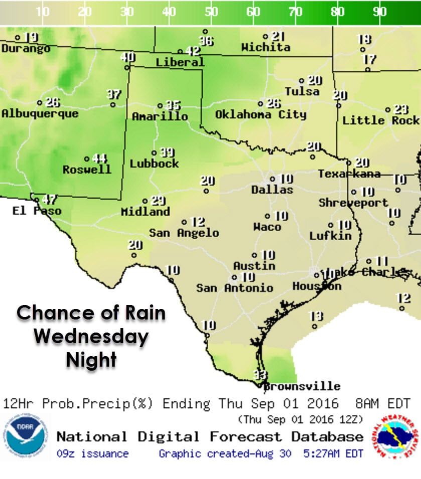
For Wednesday and Wednesday Night we’ll see rain chances a bit lower but we’ll still deal with isolated to widely scattered showers and storms during the afternoon and evening hours. The risk of flash flooding/heavy rains should also be lower. Compared to Augusts in the past I think most will agree we got by with a relatively lackluster summer.
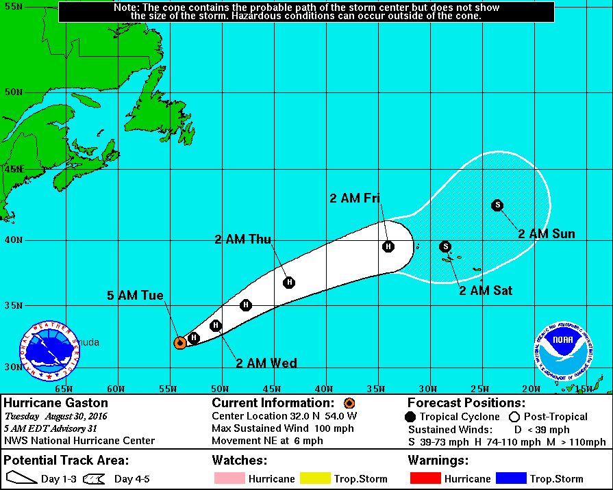
Hurricane Gaston is slowly weakening several hundred miles east of Bermuda. Moving northeast around 6 MPH Gaston will remain a hurricane for a couple more days before it weakens. This system is a classic Atlantic recurve and poses no threat to Bermuda or the United States. The only impacts for the next few days will be to shipping lanes and the fishies. It peaked in intensity yesterday with maximum sustained winds around 120 MPH.
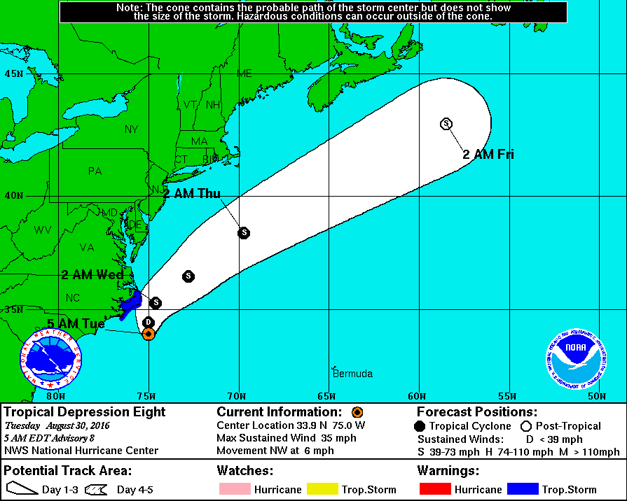
Tropical Depression #8 is located 95 miles southeast of Cape Hatteras, North Carolina as of 4 AM Central. Maximum sustained winds are in the 25-30 MPH range. Hurricane hunters investigating the system this morning have found it to be disorganized. It is still moving northwest at around 6 MPH and may bring some squally weather to the outer banks of North Carolina later today and tonight. A turn to the north is expected later today and the system should be moving northeast on Wednesday. There is a chance TD8 may become a borderline tropical storm later today as it passes near the outer banks. For that reason a tropical storm warning is in place from Cape Lookout to Oregon Inlet on the North Carolina coast. Impacts should be minimal with rough surf and a few gusts up to 40 MPH.
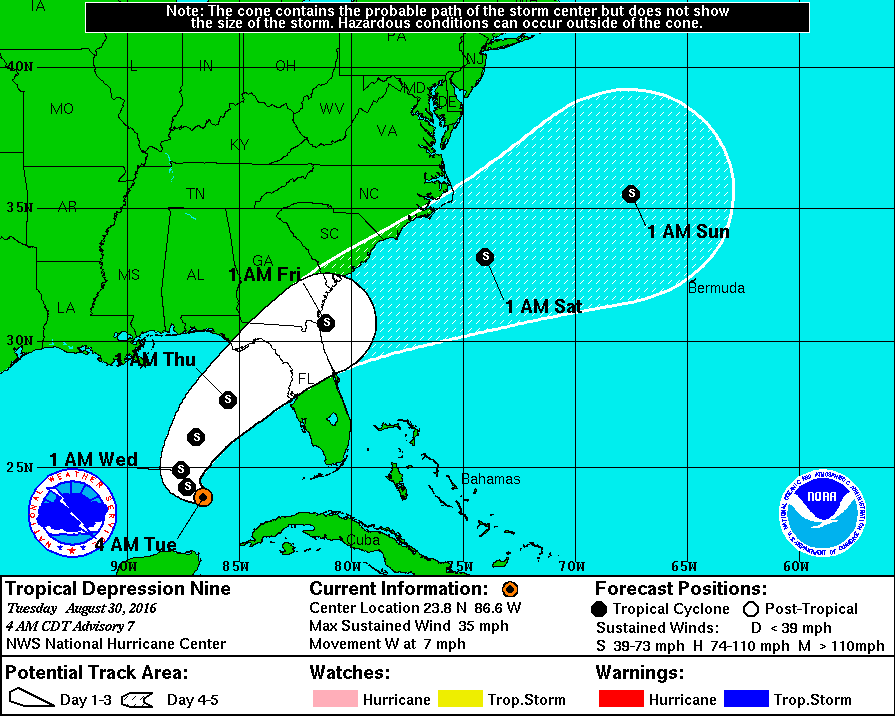
Tropical Depression #9 is located 305 miles west of Key West with maximum sustained winds around 35 MPH. The system is moving west at 7 MPH and should begin a turn to the north/northwest tonight. A sharp turn to the northeast should occur on Wednesday as the system gets picked up by slightly stronger upper level winds. Convection has blossomed overnight on the southern semi-circle of the storm and surface pressures are slowly falling. Conditions are not expected to be favorable for more than gradual intensification over the next few days. TD9 is expected to become Tropical Storm Hermine later today or tonight. The National Hurricane Center expects this system will make landfall between Panama City and Tampa on Thursday as a strong tropical storm (60-70 MPH sustained winds). As we get closer that landfall zone will be narrowed down. Heavy rains of 5 to 10 inches will be possible in Central Florida over the next few days as copious moisture from this pesky system makes efficient rainfall production. Tropical Storm or Hurricane Watches are likely to be issued later today for the west coast of Florida. I don’t see this system becoming more than a strong tropical storm or minimal category 1 hurricane. The main impacts will be flooding rains, rough surf, minor storm surge, and damaging winds over a small section of the storm. Tropical systems can bring a surprise or two to the table so we’ll keep an eye on it. TD8 will not impact our weather in Texas, but increased surf and rip currents are a good bet through the weekend.
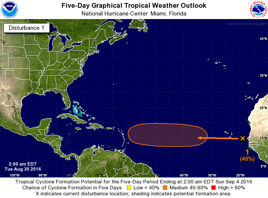
Invest 92L is in the far eastern Atlantic and is moving west around 20 MPH. This system could become a tropical cyclone next week as it moves toward the Leeward Islands. We’ll have to keep an eye on 92L since the overall pattern in early September may favor a threat to the eastern United States, but we’re way too far out to even begin to speculate on anything besides that.


0 Comments