
The National Hurricane Center has issued a Hurricane Watch for the Florida Gulf Coast from the Anclote River to Indian Pass. A Tropical Storm Watch is now in effect west of Indian Pass to the Walton/Bay County Line. A watch is typically issued 48 hours before the anticipated onset of hazardous weather conditions. TD9 should become Tropical Storm Hermine tonight and could be near hurricane strength when making landfall on Thursday in Northwest Florida. After emerging in the Atlantic this system could be a threat to portions of the eastern United States.
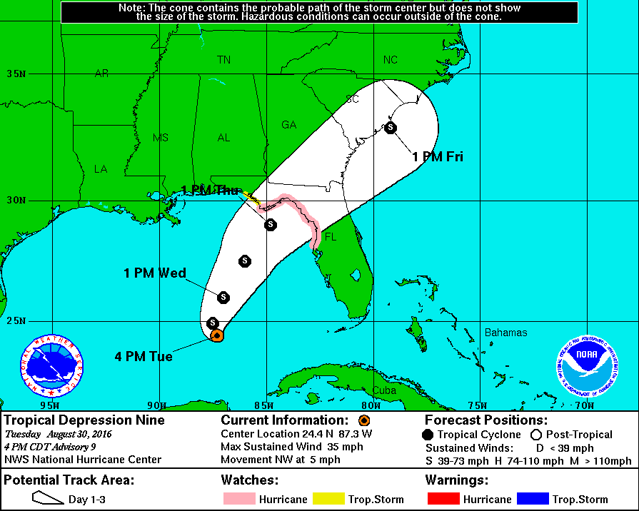
TROPICAL DEPRESSION NINE ADVISORY NUMBER   9
NWS NATIONAL HURRICANE CENTER MIAMI FL       AL092016
400 PM CDT TUE AUG 30 2016

...HURRICANE AND TROPICAL STORM WATCHES ISSUED FOR PORTIONS OF
FLORIDA GULF COAST...


SUMMARY OF 400 PM CDT...2100 UTC...INFORMATION
----------------------------------------------
LOCATION...24.4N 87.3W
ABOUT 345 MI...555 KM W OF KEY WEST FLORIDA
ABOUT 320 MI...515 KM WNW OF HAVANA CUBA
MAXIMUM SUSTAINED WINDS...35 MPH...55 KM/H
PRESENT MOVEMENT...NW OR 320 DEGREES AT 5 MPH...7 KM/H
MINIMUM CENTRAL PRESSURE...1004 MB...29.65 INCHES


WATCHES AND WARNINGS
--------------------
CHANGES WITH THIS ADVISORY:

A Hurricane Watch has been issued for the Florida Gulf coast from
the Anclote River to Indian Pass.  A Tropical Storm Watch has been
issued for the Florida Gulf coast west of Indian Pass to the
Walton/Bay County line.

SUMMARY OF WATCHES AND WARNINGS IN EFFECT:

A Hurricane Watch is in effect for...
* Anclote River to Indian Pass

A Tropical Storm Watch is in effect for...
* West of Indian Pass to the Walton/Bay County line

A Hurricane Watch means that hurricane conditions are possible
within the watch area.  A watch is typically issued 48 hours
before the anticipated first occurrence of tropical-storm-force
winds, conditions that make outside preparations difficult or
dangerous.

A Tropical Storm Watch means that tropical storm conditions are
possible within the watch area, generally within 48 hours.

Interests along the United States east coast from northern Florida
through the Carolinas should monitor the progress of this system.


DISCUSSION AND 48-HOUR OUTLOOK
------------------------------
At 400 PM CDT (2100 UTC), the center of Tropical Depression Nine was
located near latitude 24.4 North, longitude 87.3 West.  The
depression is moving toward the northwest near 5 mph (7 km/h).   A
turn toward the north-northwest is expected tonight, followed by a
turn toward the north-northeast on Wednesday.  On the forecast
track, the center will approach the coast in the watch area on
Thursday.

Maximum sustained winds are near 35 mph (55 km/h) with higher gusts.
Some strengthening is forecast during the next 48 hours, and the
depression is expected to become a tropical storm tonight or early
Wednesday.

The minimum central pressure reported by a NOAA Hurricane Hunter
aircraft is 1004 mb (29.65 inches).


HAZARDS AFFECTING LAND
----------------------
WIND:  Hurricane conditions are possible over portions of the
Hurricane Watch area by Thursday afternoon.  Tropical storm
conditions are possible over portions of the Tropical Storm Watch
area by Thursday afternoon.

STORM SURGE:  The combination of a dangerous storm surge and the
tide will cause normally dry areas near the coast to be flooded by
rising waters moving inland from the shoreline.  There is a
possibility of life-threatening inundation within the next 48 hours
along the Gulf coast of Florida from Aripeka to Indian Pass.  For a
depiction of areas at risk, please see the Prototype National
Weather Service Storm Surge Watch/Warning Graphic.  Persons located
within these areas should be prepared to take all necessary actions
to protect life and property from rising water.  Promptly follow
any instructions from local officials.

The water could reach the following heights above ground if the
peak surge occurs at the time of high tide...
Indian Pass to Aripeka...2 to 4 feet
Aripeka to Bonita Beach...1 to 2 feet

The Prototype National Weather Service Storm Surge Watch/Warning
Graphic is a depiction of areas that would qualify for inclusion
under a storm surge watch or warning currently under development by
the National Weather Service and planned for operational use in
2017.  This prototype graphic is available at
www.hurricanes.gov/graphics_at4.shtml?wsurge

RAINFALL:  The depression is expected to produce additional rain
accumulations of 3 to 5 inches over western Cuba through Wednesday,
with maximum storm total amounts up to 20 inches.  These rains
could cause life-threatening flash floods and mud slides.  Storm
total rainfall amounts of 5 to 10 inches are possible over much of
the Florida peninsula through Friday morning, with isolated maximum
amounts of 15 inches possible.  This rainfall may cause flooding
and flash flooding.


NEXT ADVISORY
-------------
Next complete advisory at 1000 PM CDT.


0 Comments