
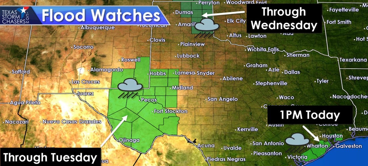
Localized flash flooding was an issue overnight in places like Andrews and east of Amarillo where some road closures were reported. No Flash flood warnings are in effect at the time of this post, but residual high water will continue to be an issue throughout the day in location that have or will receive additional heavy rains. Widespread light to moderate rain is falling across West Texas into the Permian Basin. Rain intensity has lightened across the eastern Texas Panhandle. Finally we’re watching an area of heavy rain just off the coast of Southeast Texas associated with a weak area of low pressure. Three separate flood watches are in effect across the state today. The northeastern Texas Panhandle, much of the Permian Basin, and a few coastal Southeast Texas counties are under flood watches.
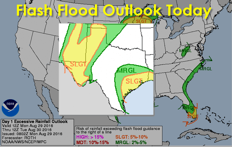
The Weather Prediction Center has highlighted the Texas Panhandle, West Texas, Permian Basin, Borderland, Southeast Texas, and the Middle Texas Coast in a slight risk of flash flooding today and tonight. Using a four level risk system a slight risk is level 2 out of 4. A slight risk means widespread flash flooding is not anticipated, but localized issues could certainly develop. Like the past couple of days we expect the most intense rains in Southeast Texas to occur during the morning and afternoon hours with a downtick overnight. Meanwhile the highest rainfall rates in the Panhandle, West Texas, Permian Basin, and Borderland will be during the late afternoon, evening, and overnight hours. Be mindful of localized flash flooding, especially if driving during the nighttime hours. Low-water crossings can be difficult to spot at highway speed.
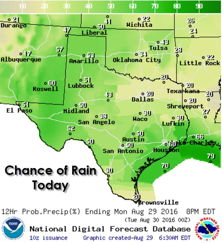
In terms of rain chances today it would be more simple to state where the lowest chance of showers/storms will be. The lowest chance for isolated showers/storms this afternoon, and mind you these chances are not zero, are in the Rio Grande Valley and north of Interstate 20 in North and Northeast Texas.The remainder of Texas has at least a scattered chance of storms this afternoon. Numerous showers/storms are possible in the Permian Basin later today and tonight. Rain chances will also be high along the coast from the Middle Texas Coast, Corpus Christi area, north into Southeast Texas including Galveston to Beaumont. Not everyone will get rained on today and it certainly won’t be a washout by any means in most locations.
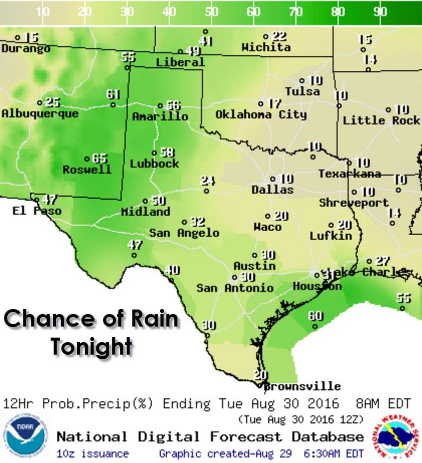
Rain chances diminish tonight across North Texas, Northeast Texas, East Texas, Central Texas, and in the Rio Grande Valley. We will see continued isolated to widely scattered activity along the coast thanks to the non-tropical low pressure offshore. Scatterded to numerous showers and thunderstorms are anticipated tonight in the Borderland, Permian Basin, West Texas, and Texas Panhandle. Widely scattered activity may occur in the Concho Valley, Southwest Texas, and South-Central Texas. The relative highest flash flood and heavy rain threat tonight will be from the Texas Panhandle south through West Texas, into the Permian Basin and Borderland. Like last night flash flooding issues should be localized, but will definitely be problematic for road conditions and low-lying areas where heavy rains fall.
Rain chances continue on Tuesday and Wednesday over the same regions as mentioned previously. Localized flooding will be possible once again on Tuesday where heavier rains fall, especially in locations that have already dealt with issues over the past few days. The cycle continues into Wednesday and Thursday. Specific rain chances and potential heavy rain/flash flooding zones for Tuesday, Wednesday, and Thursday will depend on how the previous day(s) play out and where residual boundaries remain.
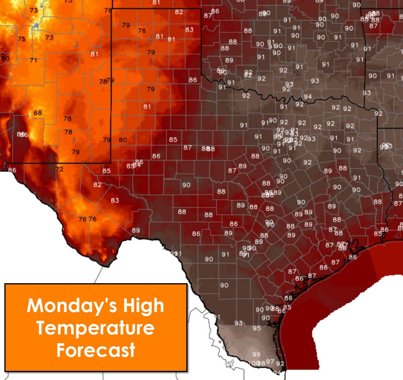
Today’s rain chances and cloud cover will keep high temperatures down in the 70s to lower 80s across the Texas Panhandle, West Texas, Permian Basin, and the Borderland. Temperatures should peak in the upper 80s to lower 90s this afternoon in Northwest Texas, Concho Valley, Big Country, North Texas, Central Texas, South-Central Texas, the Brazos Valley, Middle Texas Coast, Southeast Texas, East Texas, and Northeast Texas. The good news is that isolated to scattered showers this afternoon should help cool some locations down into the 80s. Summer popup storms may be pesky, but they do help at least make for a cooler afternoon/evening.
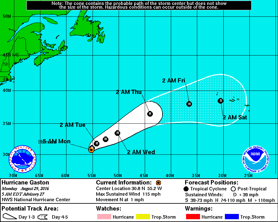
Lets take a look at the very active Atlantic Basin this morning. We have three tropical cyclones in progress, something that is impressive considering how relatively quiet the past few seasons have been. The big ole’ boy this morning is Major Hurricane Gaston located 575 miles east of Bermuda. The only thing this system will threaten is shipping lanes and fishies. Maximum sustained winds are near 115 MPH after peaking at 120 MPH last evening. This storm is moving north very slowly and will eventually get picked up and tossed northeast this week. A continued weakening trend is expected with no threat to land.
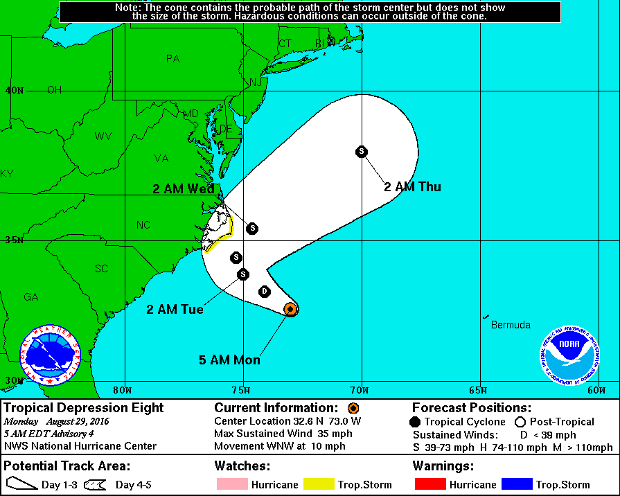
Tropical Depression #8 formed rather unexpectedly yesterday morning several hundred miles southeast of the outer banks of North Carolina. This morning TD8 is located about 230 miles southeast of Cape Hatteras, North Carolina with maximum sustained winds of 30-35 MPH. Overnight satellite imagery indicates a disorganized tropical system with little in the way of convection near the center. The hurricane hunters are about an hour away and will provide more accurate information later this morning. Based on the disorganized state and marginal conditions for intensification only slow strengthening is forecast over the next few days. A west/northwest movement will continue today before the system is quickly turned north/northeast later this week. A tropical storm watch is in effect from Cape Lookout, NC to Oregon Inlet, NC as the system may get a tad close to the outer banks before turning away.
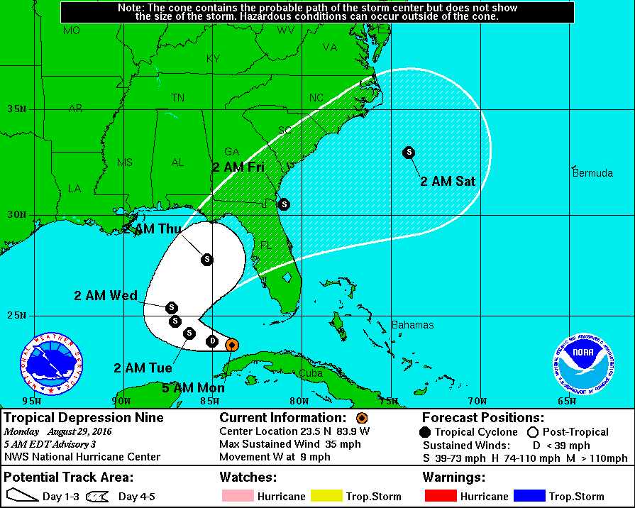
Finally we have Tropical Depression #9 located 95 miles northwest of Havana, Cuba or 155 miles southwest of Key West, Florida. This system was previously known as Invest 99L over the last week and has been a forecaster’s thorn. This system is quite disorganized this morning and is moving into the southeastern Gulf of Mexico. A slow west motion should continue today with TD9 turning northwest tomorrow and north Tuesday night. By Wednesday a turn to the northeast and a faster motion are forecast. The current forecast track forecasts TD9 to make landfall as a tropical storm on the northwest Florida coast sometime on Thursday.
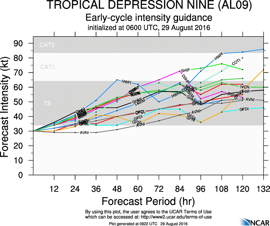
The intensity forecast for Tropical Depression #9 is complicated and difficult due to several factors. Over the past week strong wind shear has kept Invest 99L/Tropical Depression #9 from organizing itself. That wind shear continues this morning but is expected to diminish by this afternoon, and be very low by mid-week. Interaction with Cuba is also another hampering factor in intensification in the short-term. By Tuesday and Wednesday TD9 will be moving into an area of low wind shear, high oceanic heat content, and a slightly more moist atmosphere. Intensity guidance is suggesting this system will become a strong Tropical Storm before landfall on Thursday in northwest Florida. It is worth noting that some models do make this a hurricane and that is not out of the realm of possibility. Until we actually see some organization in this troll-system the forecast will stay on the lower-end of the intensity scale. Either way this system poses no threat to Texas except for increased surf later this week.


0 Comments