
It seems that every summer we now see articles from the national news media regarding a mega-cold or ridiculously hot weather pattern setting up across the country. A few media organizations started up the annual summer tradition of writing about the upcoming heat wave which will impact much of the United States. The upper midwest will indeed be dealing with oppressive heat index values over 110°F later this week as the heat ridge builds in. Technically the ‘heat dome’ or ridge is a strong area of high pressure. This high pressure is quite typical during the summer months in the Southern United States. This high pressure is what causes the jetstream to shift north thus bringing an end to our spring severe weather season. The high pressure meanders around during the summer months with varying intensities. During weaker phases when the high is to out west or east we tend to see slightly less hot temperatures with thunderstorm chances. When the high pressure is overhead or becomes strong it tends to put a lid on our storm chances. Likewise sinking air (subsidence) tends to heat more efficiently during the day. The thunderstorm complexes we dealt with earlier this month were thanks in part to the high pressure sitting off to our west. A weak northwest flow aloft allowed thunderstorms to move southeast into Texas from upstream states like Colorado and Kansas. Storms would form during the afternoon hours, organize into a squall line, and move southeast into Texas during the night. A moisture-rich enviornment supports the thunderstorm complex as it treks south/southeast in an unstable airmass. When the upper level high pressure is dominating our weather the storms stay well to our north.
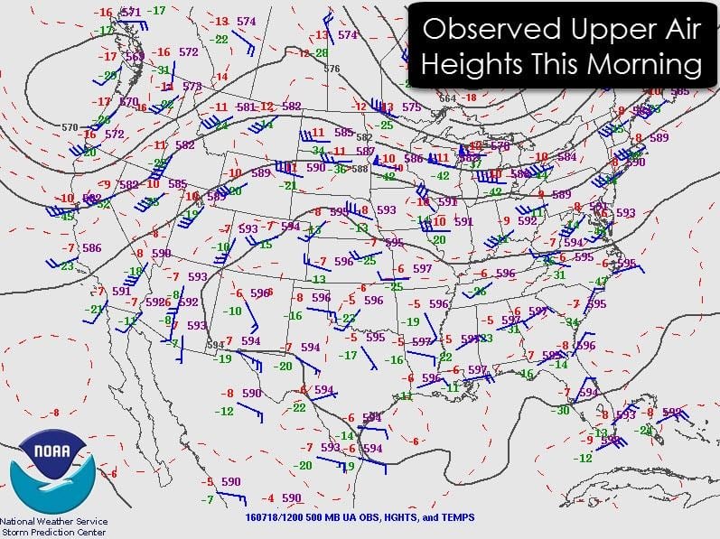
An upper air analysis taken this morning shows the high pressure aloft becoming dominant. Much of the Southern and Southeastern United States is dominated with weak upper level winds. The jetstream, indicated by the higher wind barbs and tighter compression of the isobars, is located in the Pacific Northwest into the Great Lakes. That is where we’ve seen thunderstorms over the past few days. While high pressure is in place we will be dealing with a daily occurrence along the coast – the sea breeze. As the sea breeze moves inland each day we’ll see isolated to scattered storms pop up in Southeast Texas along the coast into the Rio Grande Valley. This activity is diurnally driven and dissipates by early evening.
The high pressure in place now will solidify its hold over the Southern United States as we continue through the week. The two graphics below indicate upper air heights will remain highest over northern sections of Texas into Oklahoma. This pattern will support a stagnant air mass with heat and a great excuse to head to the beach. Without widespread rains over the past few weeks our humidity values are starting to become more manageable along and west of Interstate 35. Lower humidity values mean heat index values won’t be as high, but temperatures will heat more efficiently. Several days of triple digit heat are probable later this week into the weekend along and west of Interstate 35. Along with the lower humidity values and heat there will be an elevated risk of grass fires. Surface grasses are drying out and supporting an increasing risk of brush/grass fires. Humidity values east of Interstate 35 will be higher with heat index values near or above 105°F a good bet. Air temperatures will ‘only’ get into the 90s but with heat index values considered it’ll be plenty hot.
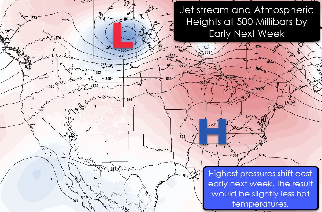
By early next week the high pressure aloft should shift into the southeastern United States. While no storm systems are currently forecast to impact our area we should see temperatures drop a couple of degrees. Make no mistake we won’t be dealing with a cool snap next week. Temperatures will stay in the 90s and it’ll be your typical summer heat in Texas. We just may not see as many triple digit readings.
Meanwhile in the tropics… Saharan Dust from across the Atlantic Ocean is keeping the Atlantic tropical basin quiet. Until we see the dust abate the prospects for tropical cyclone development remain low. You need low wind shear, plenty of moisture, warm sea surface temperatures, and just the right amount of other ingredients to produce tropical cyclones. That dust means dry air and that is extremely detrimental to hurricanes.


0 Comments