
Severe Weather Outlook
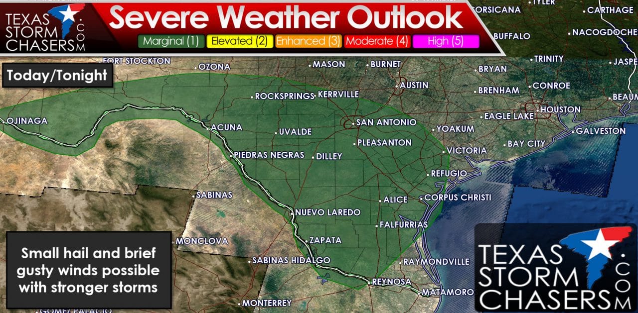
The Storm Prediction Center has placed South Texas, South-Central Texas, and Southwest Texas in a category 1 severe weather risk for today and tonight. On a 5 level system 1 is the lowest and 5 is the highest. Known as a marginal severe weather risk this means we could have a couple strong to marginally severe storms through tonight. The stronger storms may produce localized gusty winds of 50 to 60 MPH and small hail. Copious amounts of moisture are in place and wind shear values are fairly weak. Both factors indicate any severe weather threat with one storm should be short-lived. Think of these storms as the ‘popcorn’ type storms we deal with on summer afternoons. They pop up in a hurry, make a racket, but usually taper down within 30-45 minutes.
Flash Flood Watches
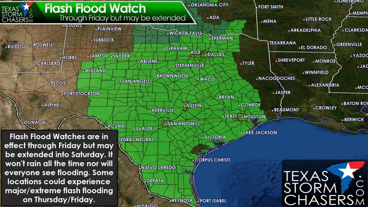
We now have flash flash flood watches including the Permian Basin, Concho Valley, Big Country, Northwest Texas, North Texas, Central Texas, the Hill Country, Southwest Texas, South Texas, Rio Grande Valley, the Coastal Plains, Middle-Texas Coast, the Brazos Valley, and Southeast Texas. Pretty much if you’re within the ‘middle’ of Texas you’re in a flash flood watch. These watches go through Friday but I wouldn’t be surprised to see them extended in duration through Saturday. Shower and thunderstorm coverage is expected to increase this afternoon with pockets of flooding a good bet. The heaviest activity today may produce hourly rainfall rates of two to three inches per hour. Areas that haven’t seen much rain over the past few weeks should be able to handle around three inches of rain before flash flooding ensues. Those that have had a bunch of rain over the past two weeks can only handle an inch of rain before new flooding issues arise. The latest forecast data suggests Thursday afternoon through Friday morning may be the timeframe of most concern for localized, extreme rainfall rates for Central Texas, South Texas, the Brazos Valley, East Texas, and Southeast Texas.
Total Rain Amounts Expected through Sunday
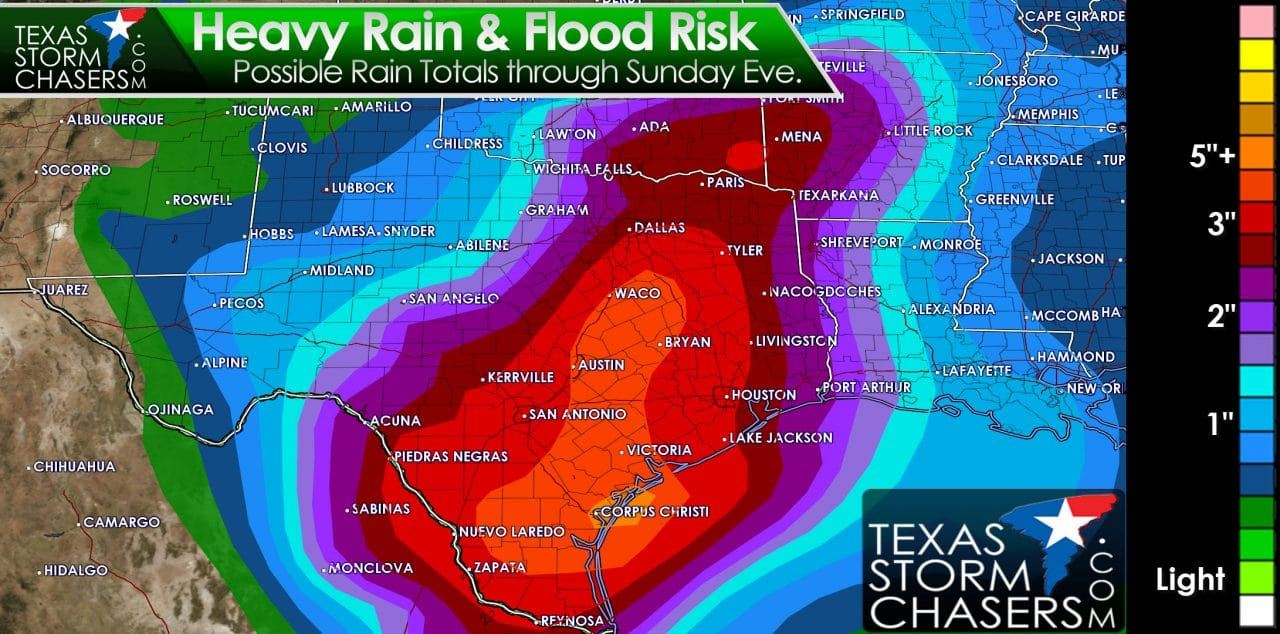
Let me preface this by saying the total rainfall graphics we share are for generalized amounts over a region. There will be folks who see less and folks that see a whole lot more over a small area. It won’t rain the entire period nor will this rain total forecast likely play out exactly as depicted. Mother Nature doesn’t read maps and certainly doesn’t give a hoot about what weather folks try and predict. Latest data continues to suggest the heaviest rains should fall from Central Texas into Southeast Texas through the Coastal Plains and South Texas. Those regions could see widespread rain totals of 3 to 5 inches with isolated amounts over 10 inches possible by Saturday. Rivers remain in flood, soils are saturated, and we simply can’t take that much rain without major issues. There is the possibility of major flooding in locations that receive 5+ inches of rain – especially if that falls where we already have flooding ongoing. The problem is forecasting where the heaviest rains are going to fall. Because we don’t have any large-scale pattern to help predict the heaviest rain axis we’re limited to within about 12-18 hours of accurate forecasting. That’s why there have been some changes with today’s forecast totals compared to yesterday. The heaviest activity could produce hourly rainfall rates of 3 to 4 inches per hour tomorrow with training thunderstorms possible. Training thunderstorms are where we see storms keep developing over the same areas. Those are the kinds of events where some locations could easily pick up 10+ inches of rain in a few hours. Needless to say extreme flash flooding is a distinct possibility where we see those kind of rain totals. It won’t rain everywhere all the time nor will everyone see flooding – but I do believe we will be dealing with pockets of extreme flooding on Thursday and Friday. Where exactly is still up for debate. If you live in a flood-prone area you definitely need to keep up with the weather information. Move to higher ground immediately if water approaches your location.


0 Comments