
Let me start out by saying additional thunderstorms are expected to form overnight across the Big Country and North Texas. Some of those storms could be strong with small hail, frequent cloud to ground lightning, and brief heavy rain. The overall severe weather risk will be lower compared to activity earlier this afternoon. Most of this activity should weaken by the mid-morning hours Monday.
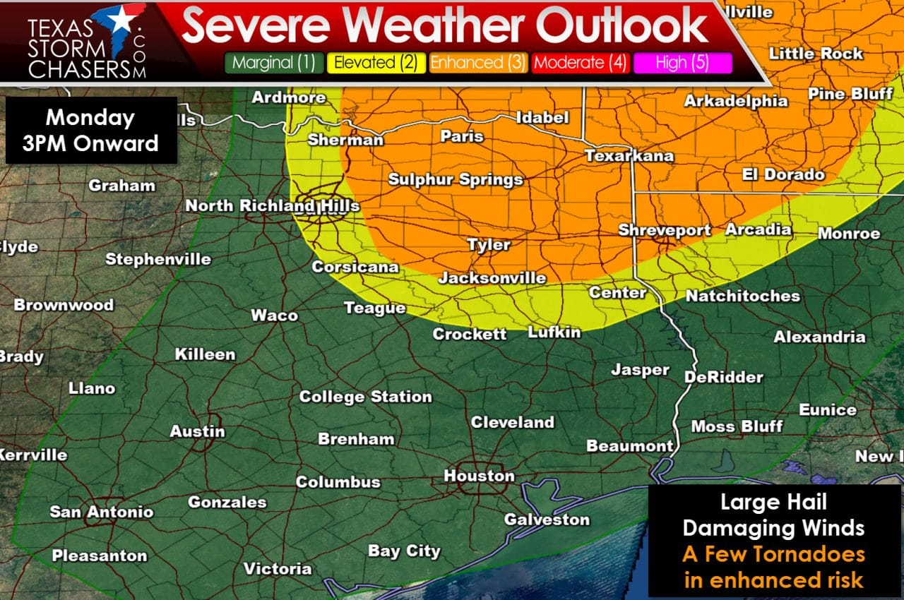
Here we have the latest severe weather outlook for Monday issued by the Storm Prediction Center. Much of the severe weather risk tomorrow will be confined to eastern sections of North Texas, all of Northeast Texas, and northern sections of East Texas. We do note a category 1 risk of severe weather includes Central Texas, the Brazos Valley, and Southeast Texas. However a strong cap will limit overall thunderstorm potential in those regions. The cap will be weaker across Northeast Texas and that region will be closest to the upper level lift needed to erode the cap. The SPC has placed an enhanced risk of severe weather – category 3 on a 5 level scale – that includes Sherman, Paris, Texarkana, Sulphur Springs, Tyler, Longview, and Marshall. The standard category 2 severe weather risk includes the D/FW Metroplex and Lufkin. There’s a pretty tight gradient from category 1 to category 3 due to the expected cap that will keep storm coverage limited with southward extent.
Another forecast item we’ll be keeping a close eye on is the dryline’s position tomorrow afternoon. If the dryline ends up further west than currently forecast the severe weather risk will likewise also shift west. Since the dryline will be somewhere over D/FW that 20 mile shift west or east will dictate a lot. That positioning is something we’ll refine on Monday morning. Regardless of the dryline’s position we anticipate thunderstorms will begin developing after 3 PM just to its east. Those developing storms could intensify quickly and become severe. Large hail up to the size of tennis balls and localized damaging wind gusts over 60 MPH would be possible with the strongest storms tomorrow afternoon and evening. The risk for a few tornadoes will exist in the enhanced risk zone where low-level wind shear will be stronger. In addition we’ll have to keep an eye out for any outflow boundaries left over from storms tonight since those can enhanced low-level wind shear.
Please check back several times for forecast updates on Monday if you live in North Texas, Northeast Texas, and East Texas. As the forecast evolves we could see changes to the forecast.


0 Comments