
The radar is looking much better this morning compared to what we saw late last evening. Yet another major Texas city experienced a hail event overnight – which while good news for dent repair and body shops – really stinks for the rest of us. Luckily the severe weather threat has ended and we don’t expect any issues today or tomorrow. That may change on Friday as we set up for another very active period of weather. Residual showers continue across Texoma this morning with a larger area of rain moving northeast across Oklahoma. Showers are also occuring in Southeast Texas. All rain activity should diminish by late afternoon with generally dry weather tonight through Friday afternoon.
All that begins to change Friday night. Rain chances begin increasing during the late afternoon hours across far western sections of Texas. Those rain/storm chances will increase from west to east this weekend and continue into at least the first half of next week. A relatively rare upper air pattern called an omega block will set up across the eastern United States. That omega block will prevent a storm system to our west from ejecting east – thus providing several days of rain/storm chances. We need the rain so that’s the good news. The bad news is there could be some severe weather issues and at least localized flooding problems, especially by early next week. Here are the day-by-day rain chances as things stand now. I don’t think it’ll be raining all the time in one given location – but there will certainly be times it’s pouring.
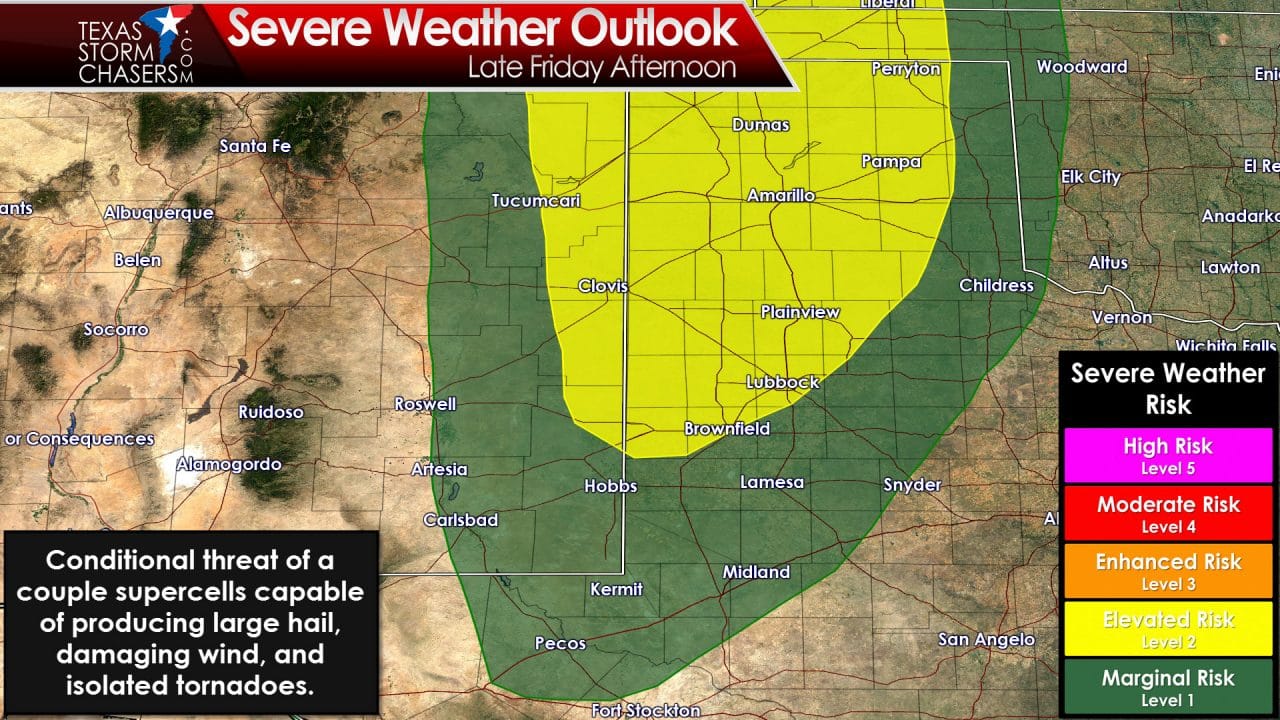
In terms of severe weather the first day we’ll be watching is Friday. A dryline will set up in eastern New Mexico by the afternoon hours. While moisture values that far west will be mediocre there should still be enough moisture to allow organized thunderstorms to develop. One cavet is if we see too much clouds and a more stable atmosphere. Assuming we have a mix of sun and clouds a couple severe storms should fire up by the late afternoon hours in eastern New Mexico to into the Texas Panhandle and western sections of the South Plains. Storms that develop will move east into Texas by the late afternoon or early evening. Some of the storms could be severe with hail larger than the size of a golfball, localized damaging wind gusts over 65 MPH, and even a threat of a couple tornadoes. The threat for very large hail and tornadoes will depend on how much moisture is available and how unstable the atmosphere can become. We should get a better idea on those ingredients as we get into Thursday and closer the timeframe of interest. Storms will move east Friday Night with a gradual decline in the severe weather risk. Some storms could certainly remain strong to marginally severe with a threat of hail into the overnight hours Friday.
The severe weather threat on Saturday is uncertain but may be limited due to widespread precipitation and clouds. If a threat of severe weather were to develop on Saturday it would likely be in West Texas. Depending on how things set up the threat for a few severe storms may spread into the Big Country, Concho Valley, Hill Country, and Central Texas on Sunday. At this time no official severe weather risk outlines have been designated – but they may be in later outlooks as things become more clear.

The upcoming rainy pattern certainly looks good for a widespread soaking. At this time the heaviest rain totals by Sunday evening are progged to be across the Texas Panhandle into Northwest Texas and West Texas. Some locations could could pick up 3 to 5 inches of rain out there by Sunday Night. Widespread 1 to 2 inch rains are expected across North Texas, the Big Country, Concho Valley, and Central Texas. Rain chances continue on Monday and Tuesday so rain totals will increase after this graphic as well. Assuming we can get most of the rain to fall over a timeframe of a couple days the threat of major flooding should be limited. If we see 3 to 4 inches of rain fall in a few hours than we will likely have to deal with some flash flooding issues. The flash flood threat certainly does look to exist across the Texas Panhandle, Northwest Texas, South Plains by Saturday and Sunday. The threat of flooding may increase further east by Sunday and Monday. I wouldn’t be surprised to see flash flood watches issued once we get closer to the weekend. Any drought conditions that have developed look to be eradicated once again. The fire danger should also been quelled for a time too.


0 Comments