
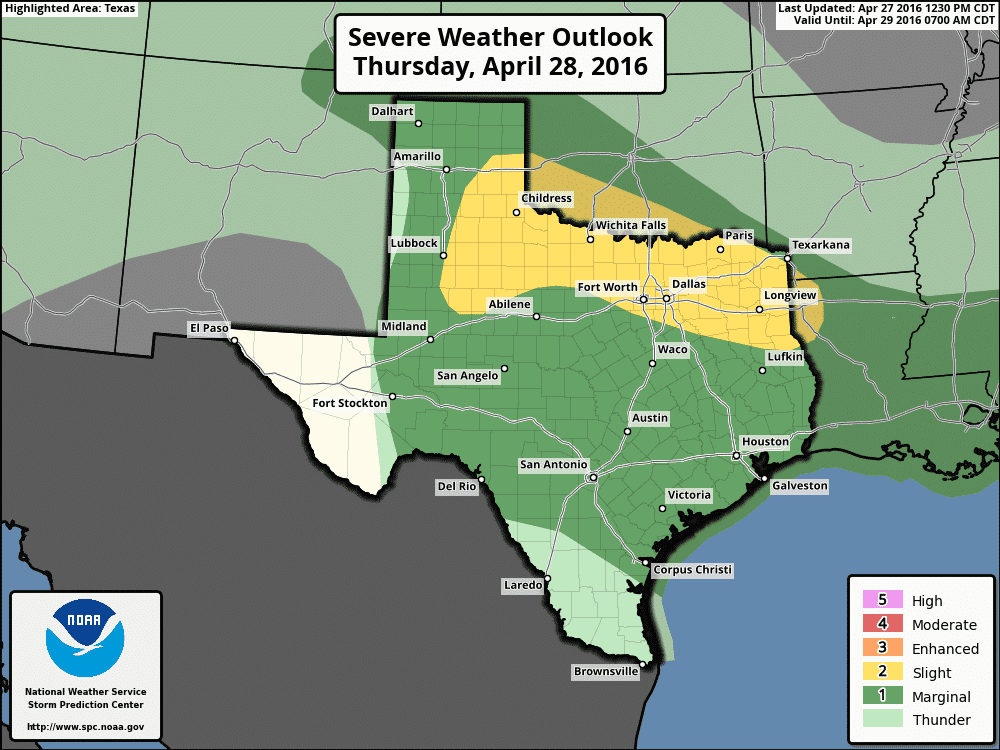
Quiet weather is expected for the next 24 hours, then mother nature will be kicking things back into gear beginning Thursday night with rain and storms back in the forecast once again. The next upper level system is currently over central California and will be diving southeast into Arizona and New Mexico by tomorrow. While much of north Texas down into central Texas has enjoyed less humidity today thanks to drier air filtering in behind last night’s storms, moisture will be on the uptick again beginning tomorrow. Lift from the approaching upper level system will kick off a round of rain and scattered thunderstorms late tomorrow and into tomorrow night from the southeastern Texas panhandle and rolling plains across much of north central Texas along the Red River. It’s likely that we’ll see storms develop first along the dryline across the southeastern Texas panhandle/rolling plains Thursday evening, with development further east across north Texas during the overnight hours. The rain and embedded thunderstorms expected across north Texas will be building in from south to north overnight Thursday into Friday and are expected to drop anywhere from 1/4 to 1/2 inch of rain before moving into Oklahoma Friday morning. Widespread severe weather is not expected; however we do have a chance at see at least a few strong to severe storms with large hail and high winds as the main threats.
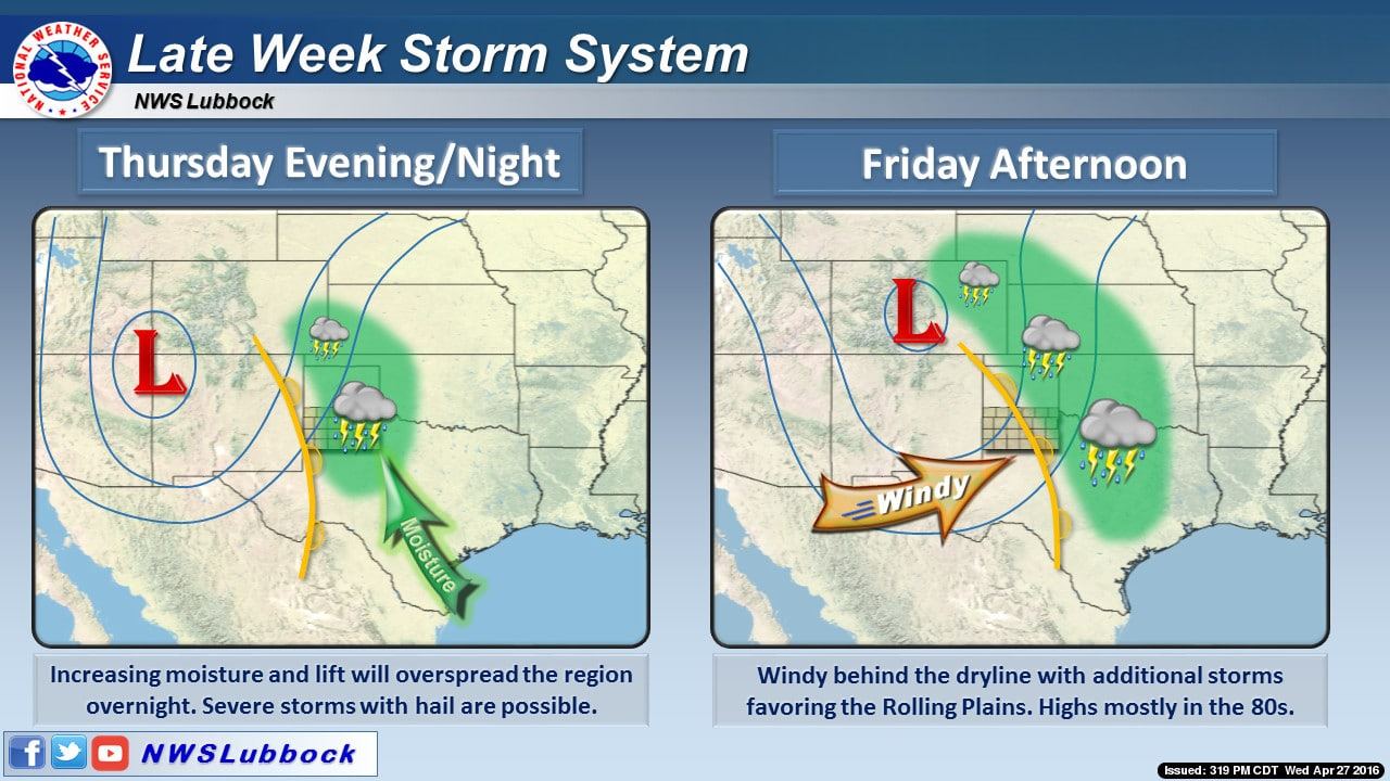
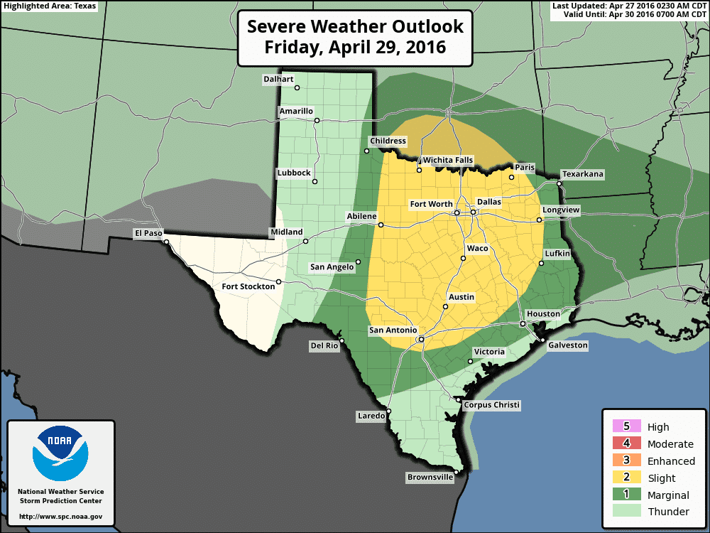
For Friday, another risk of strong to severe storms exists across much of central and north Texas as the upper level low continues to drift east. We may have scattered rain and storms ongoing early Friday morning across north Texas, but at this time those are expected to move up into Oklahoma in time for the atmosphere to recover by Friday afternoon. If the atmosphere can recover sufficiently by early Friday afternoon, strong to severe storm development is expected east of the dryline across the eastern Permian Basin, eastern Big Country, central Texas, north Texas and western portions of east Texas. Ample instability will be in place and any storm that becomes severe will carry the threat of large hail, damaging winds and a few tornadoes possible. There is still some uncertainty as to which areas within the Slight Risk will be most impacted by severe storms on Friday, so be sure to check back for updates as this gets closer!
Last but not least, my personal thoughts on yesterday’s “busted” forecast….
For days leading up to yesterday evening, the various forecast models were spitting out solutions that looked downright scary. Solutions that we don’t always see each Spring which elevated concerns about a potential tornadic outbreak across parts of Texas, Oklahoma and Kansas. The media, like it always does, latched onto that from the beginning and continued to spread the message that something really really bad could happen. And we did have a few bad things happen…namely the three tornadoes that touched down in Grayson county last night (EF-1 in Whitesboro, EF-1 in Howe, and an EF-0 in Bells). For the residents impacted by that storm, the forecast for dangerous tornadoes verified. For the rest of us, not so much…and now forecasters are under fire for over-hyping the event by getting the forecast all wrong. In the storm chasing community, we call it the Hype Train…and everyone was onboard, including us. Why? Because it really could have happened.
There were so many ingredients in place yesterday which made the atmosphere quite volatile…more volatile than we typically see in April. But, as always, the devil is in the details, and not all those details can be picked up by any of the forecast models until just shortly before or as the event unfolds. Uncertainty was continually part of the message conveyed by the Storm Prediction Center in their Severe Weather Outlooks for yesterday’s event. Uncertainty about how far east the dryline would migrate…uncertainty about how far south into Texas the threat would extend given the colossal cap in place early on…and considerable uncertainty existed on how quickly storms would transition from discrete to linear given the lack of low to mid-level directional flow. So, in one hand you have a forecast that looks like a tornado outbreak is possible, and in the other hand you have a forecast for a raging squall line. The question then becomes how do you warn the public that it could get really bad, but then again it might not. Do you go with the lesser threat and just cross your fingers that all heck doesn’t break loose? Or, do you warn the public based on the potential of more significant weather and hope it doesn’t materialize?
Prepare for the worst, hope for the best. That will always be the stance taken by forecasters. Why? Because a busted forecast doesn’t mean lives or property were lost by getting the forecast wrong. There is absolutely no 100% accuracy in forecasting…not by anyone. The mechanisms that produce severe weather are so incredibly complex that nobody will ever be able to achieve 100% accuracy…at least not in our lifetime..and probably not even our grandkids’ lifetimes. The job of forecasters is to forecast the potential impacts…which sometimes means the worst possible outcome, then prepare their forecast in hopes that people will listen, take action and stay safe. We will continue to do the same here with our forecasts.


0 Comments