
An active period of widespread rain and thunderstorms will begin tomorrow and spread east through the weekend and next week. Unlike the past couple of systems this one will be more of a heavy rain maker versus a severe weather event. There will certainly be some risk of severe storms on Friday and Saturday – but the threat will shift to heavy rain by Saturday, Sunday, and Monday. While there will be multiple days of rain chances it won’t be a complete washout for that entire period. The good news is the upcoming rainy pattern should help jump start spring vegetative growth, eliminate most drought resurgence in areas that need rain the most, and reduce short-term fire danger. Rain chances could continue into the upcoming work week. Here are the day-by-day rain chances as of this morning. Forecast uncertainty increases with time so there will likely be refinements.
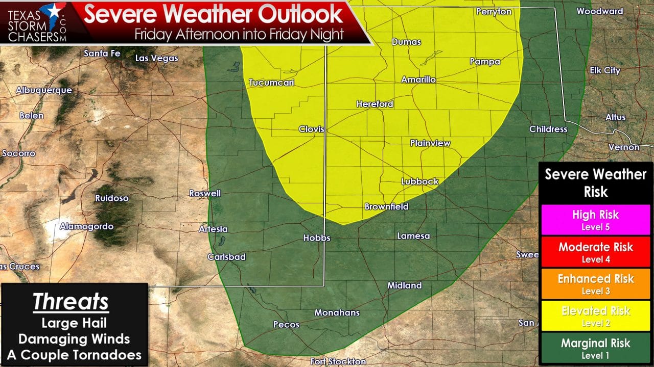
The threat of severe thunderstorms will increase late Friday afternoon across the western Texas Panhandle. The storms that form in the late afternoon hours will likely be discrete supercells. Storm movement will be north/northeast. The dryline may set up in the western row of counties in the Texas Panhandle to the South Plains late tomorrow afternoon. Storms that fire off the dryline will move north/northeast and may be severe with large hail, localized damaging wind gusts, and an isolated tornado threat. The dryline will retreat west during the evening hours tomorrow and additional storms may fire in eastern New Mexico and could also be severe.
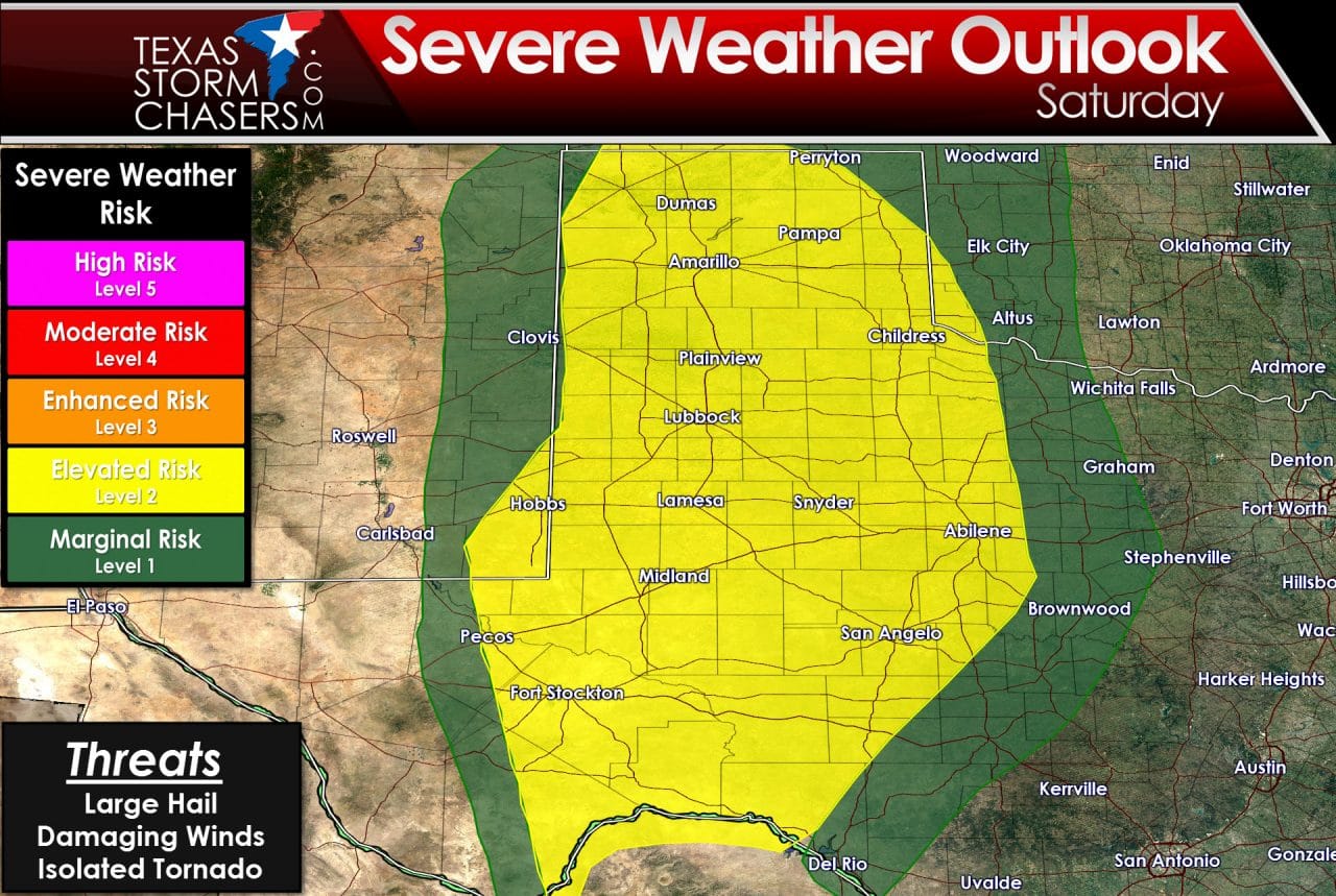
The threat for a few severe storms remains uncertain on Saturday due to widespread precipitation and cloud cover expected. A broad area of severe weather risk has been highlighted including the Permian Basin, Concho Valley, Big Country, South Plains, Rolling Plains, West-Central Texas, and the Texas Panhandle. The strongest storms may produce quarter size hail and localized wind gusts up to 60 MPH. The extend of the severe weather risk will depend on unstable the atmosphere becomes on Saturday. If widespread rain/clouds do keep the atmosphere more stable the severe weather threat will be isolated. We’ll just have to see how things play out.
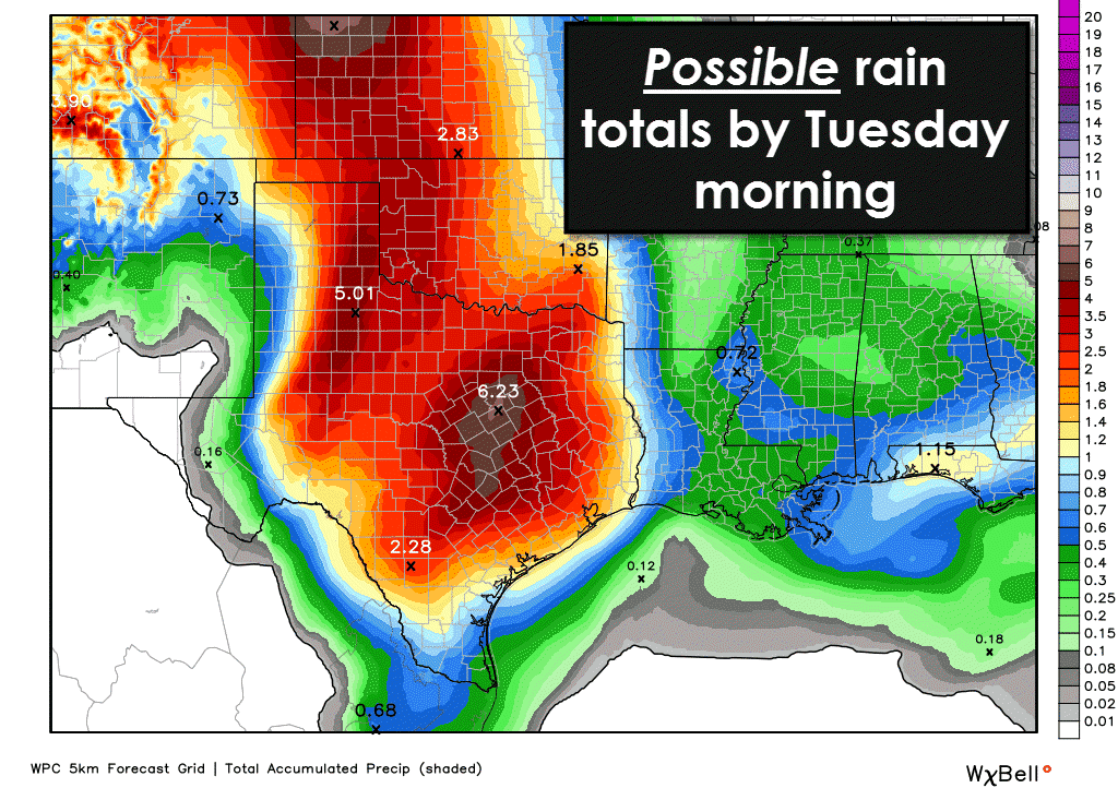
Confidence is increasing that this upcoming period will be a very wet one. Widespread 2 to 4 inch rain totals with isolated amounts over 6 inches are possible across the eastern Texas Panhandle, Rolling Plains, eastern Permian Basin, Northwest Country, Big Country, Concho Valley, Hill Country, South-Central Texas, Central Texas, North Texas, the Brazos Valley, Northeast Texas, East Texas, and Southeast Texas by Tuesday morning. The threat of flash flooding looks to increase on Saturday across the eastern Panhandle, Rolling Plains, into West-Central Texas. That risk may spread east on Sunday/Monday. Drought conditions across the eastern half of the Panhandle into Northwest Texas look to be obliterated this weekend. We’ll continue to watch the heavy rain/flooding potential and refine the forecast as we get into the weekend.


0 Comments