
The Storm Prediction Center has issued a Tornado WATCH for portions of far northeastern Texas this evening until 8pm. NOTE: This WATCH only includes TWO counties in far northeast Texas…Bowie and Cass Counties…which includes the cities of Texarkana, New Boston, Queen City, Atlanta and Linden.
A strong and compact upper level low is currently tracking east across south central Oklahoma which will have the potential to spark a few strong to severe storms across far northeast Texas before the line moves east into western Arkansas and northwestern Louisiana. Large hail and damaging winds will be the primary threats within any storm that can manage to fire up before moving into either Arkansas or Louisiana. Tornadoes are also possible within any of the stronger storms that manage to develop. What we’re seeing right now in the short-range models is for the line to form along and to the east of the TX/AR/LA border which would leave northeast Texas behind most of the activity. Still…models can and have been wrong, so do keep an eye out this afternoon for signs of threatening weather. By and far, the greatest threat for severe storms and tornadoes remains across parts of central and southern Arkansas this evening.
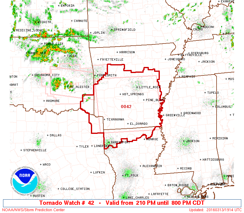
TORNADO WATCH NUMBER 42
   NWS STORM PREDICTION CENTER NORMAN OK
   210 PM CDT SUN MAR 13 2016

   THE NWS STORM PREDICTION CENTER HAS ISSUED A

   * TORNADO WATCH FOR PORTIONS OF
     CENTRAL AND SOUTHERN ARKANSAS
     NORTHERN LOUISIANA
     SOUTHEAST OKLAHOMA
     NORTHEAST TEXAS

   * EFFECTIVE THIS SUNDAY AFTERNOON AND EVENING FROM 210 PM UNTIL
     800 PM CDT.

   * PRIMARY THREATS INCLUDE...
     A FEW TORNADOES LIKELY WITH A COUPLE INTENSE TORNADOES POSSIBLE
     WIDESPREAD LARGE HAIL LIKELY WITH ISOLATED VERY LARGE HAIL
       EVENTS TO 3 INCHES IN DIAMETER POSSIBLE
     SCATTERED DAMAGING WIND GUSTS TO 70 MPH POSSIBLE

   SUMMARY...THUNDERSTORMS WILL DEVELOP SOON OVER PARTS OF SOUTHEAST
   OK/NORTHEAST TX/SOUTHWEST AR AND SPREAD ACROSS THE WATCH AREA.
   SUPERCELLS CAPABLE OF VERY LARGE HAIL AND A FEW TORNADOES ARE THE
   MAIN CONCERN THROUGH THE EARLY EVENING.


0 Comments