
The latest short-range model data is just beginning to roll in. So far, not noting any significant changes to David’s early evening blog with our thoughts on how tomorrow may play out. If you missed it, check it out here.
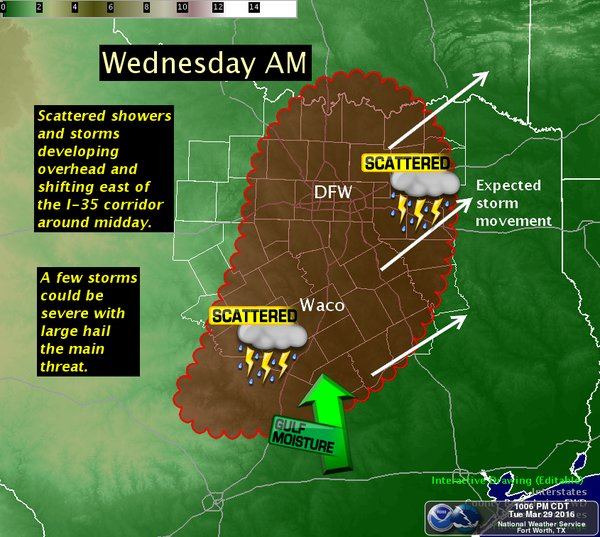
- Showers are still expected to develop tonight and increase in coverage tomorrow morning across much of central, north central and into eastern Texas.
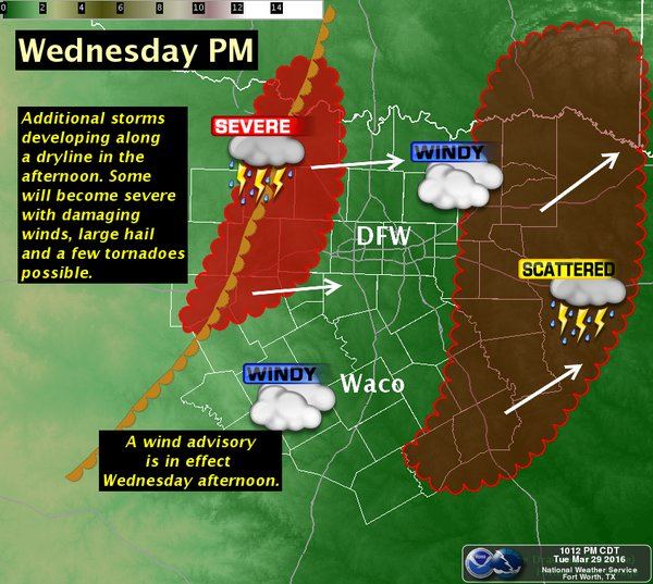
- We will likely be looking at two rounds of storms…the first during the early to late morning hours along and east of I-35, and possibly a second round along the dryline later in the afternoon.
- A strong upper level disturbance will push east and increase lift across the region along and east of the I-35 corridor during the early to late morning hours tomorrow.
- A dryline will also push eastward across west central Texas during the afternoon, but it’s still unclear just how far east the dryline will push by peak daytime heating tomorrow. Models continue to differ in its location…some pushing it as far east as I-35…some keeping it further to the west. This is likely something that will not fully resolve until we get past daybreak tomorrow.
- Moderate instability will be in place by early tomorrow across parts of central and north central Texas, with most of the current short-range models eroding the cap before 10am which will allow storms to become more widespread and increase in intensity by mid-morning and continue through the early afternoon hours as upward forcing from the upper level system arrives and pushes east. Some of these storms could become severe by mid to late morning with the threat of large hail up to the size of baseballs and damaging winds mainly along and east of the I-35 corridor.
- The tornado threat is not as high, but is not zero either. Greatest threat for tornadoes will be during the late afternoon to evening hours with any storms able to develop along the dryline.
We expect this forecast will refine considerably by morning, especially with respect to additional storm development tomorrow evening along the dryline which will be highly dependent on how quickly the atmosphere closer to the dryline can recover after the early day storms have moved east. Most of the current short-range models are showing at least a few cells developing, so the thought now is for isolated to scattered development along the dryline by late afternoon. If storms do develop here, they will have the potential to quickly become severe. We will continue to monitor the forecast overnight and will post updates with the latest developments.


0 Comments