
Our weather of late across the state has many of us asking what happened to the predictions of a cooler than average and wetter than average Winter for Texas due to the strong El Nino pattern. And with Spring storm season right around the corner, it also has us wondering if this lackluster El Nino will have an impact on tornadoes and other forms of severe weather this coming Spring. Our precipitation in December ended up ranking slightly above average across the state..especially for areas along and east of I-35. For January, we ended up slightly below average, and so far this month, we’re trending below average in precipitation once again. That’s not exactly what was projected back when we began talking about the onset of a strong El Nino pattern. We expected the above average precipitation chances to continue on through the entire winter. However, data for January…and now into the first of February…is hinting that may not happen.
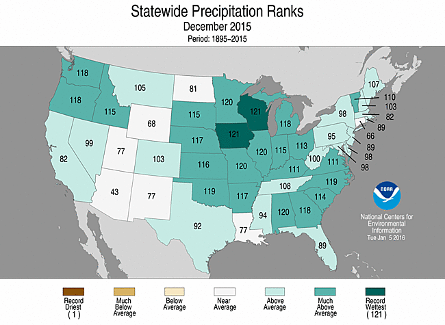
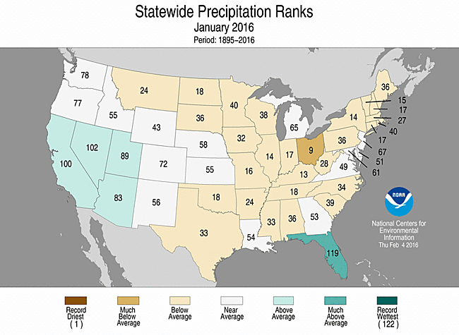
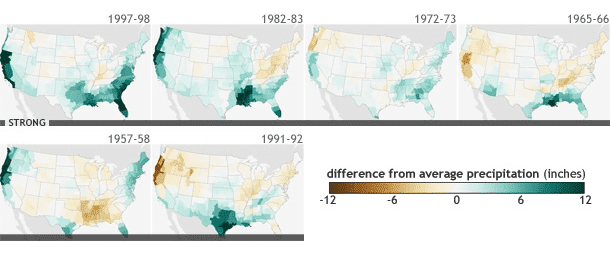
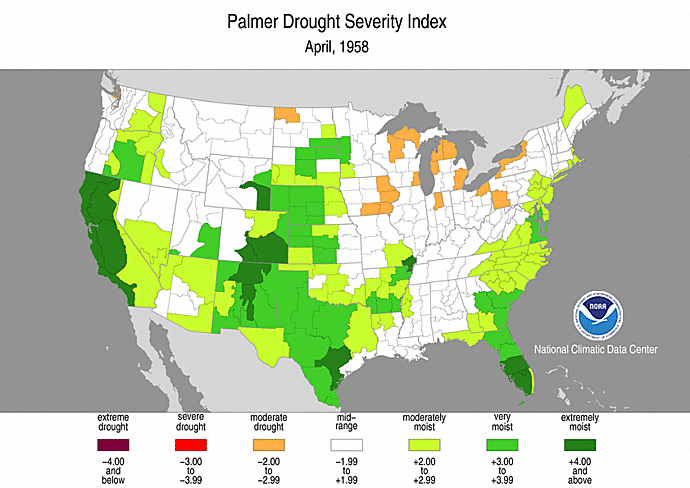
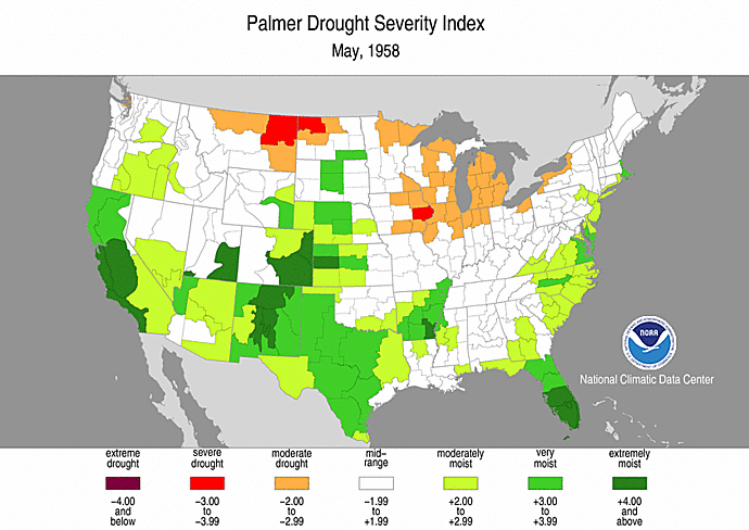
This past weekend, The National Weather Service office in Ft. Worth took a look at the data collected so far on this Winter’s strong El Nino pattern and compared it data on past strong El Nino events. They took a look at analogs from these past events, compared it to the data we have leading up to this event, and concluded that we may be seeing a similar pattern to what we saw back in the winter of 1957-58. As you can see on the plots below…we ended up drier than average across the northern half of the state and wetter than average across the southern half of the state.
The El Niño is now past its peak, and sea surface temperatures in the equatorial Pacific are cooling. However, the current sea surface temperature anomalies are still among the warmest on record, thus, strong El Niño conditions are still in place. But so far in 2016, there have been very few rainmaking systems from the Pacific that have impacted Texas, and precipitation totals for the year to date are below normal throughout North and Central Texas.
How unusual is this, particularly with strong El Niño conditions in place? Although El Niño winters tend to favor above normal precipitation, this is not always the case. The driest among the strong El Niño events (1957-1958) has been a remarkably good analog for 2015-2016:
-Very wet spring ends a multi-year drought (1957 and 2015)
-July and August are very dry (1957 and 2015)
-Wet autumn (1957 and 2015)
-Winter with near to below normal precipitation (1957-1958 and 2015-2016)
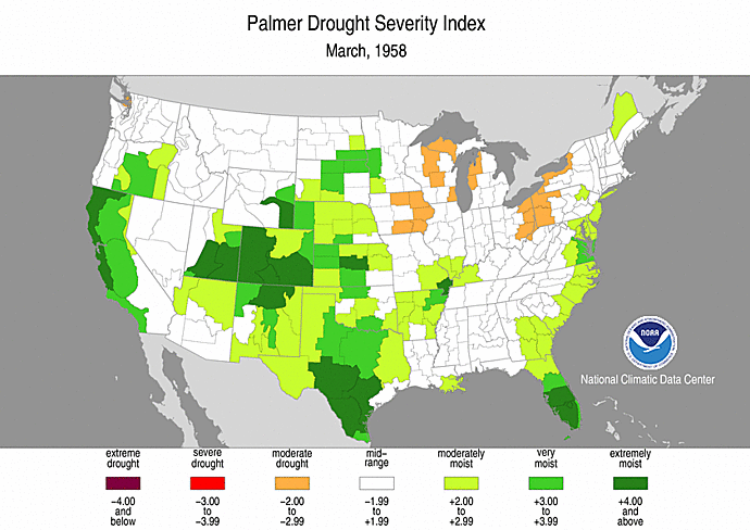
So naturally the next question is what impact this will have on our Spring rain and storm season? The NWS office in Ft Worth goes on to say that Spring of 1958 was pretty wet for us…and it also featured below average numbers of tornadoes. More on that further down the in the blog. The images below from the Palmer Drought Index for the months of March, April and May of 1958 attest to the fact that we did transition into a wet spring that year. And we have the current precipitation outlook from the Climate Prediction Center which still supports the probability of above normal rainfall through Spring.
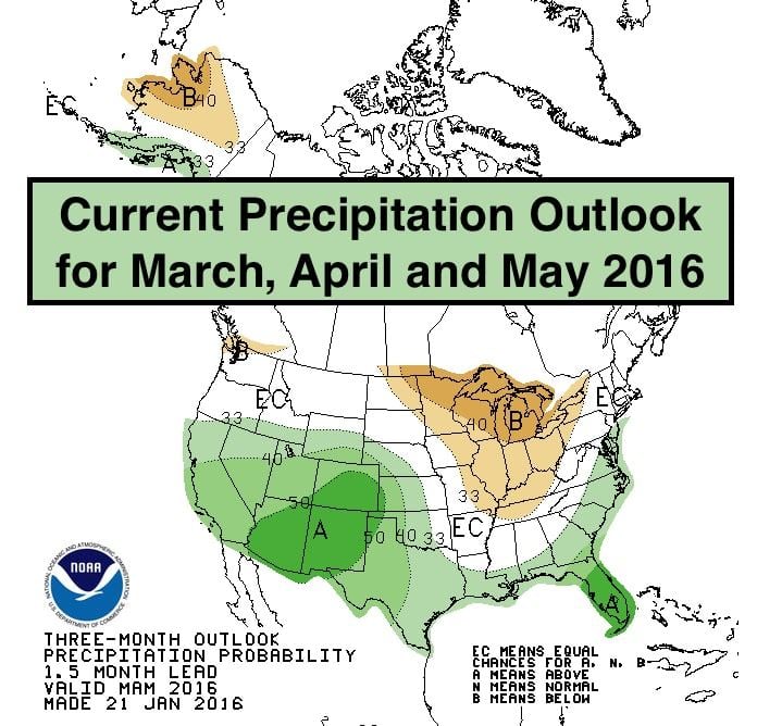
Does this mean we will begin to see more rainfall by early next month and potentially a wetter than average spring? Maybe. The Climate Prediction Center Outlook keeps us within a higher probability of rain during the months of March, April and May. But we have to remember, El Nino is not the only factor which impacts the weather. All we can say for sure at this point is yes, we will get rain this Spring…we always do…but we cannot discount the possibility that we may not get the rain we expect, much like what we’ve seen so far this winter.
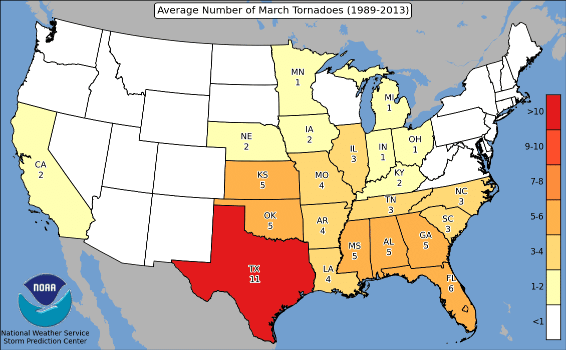
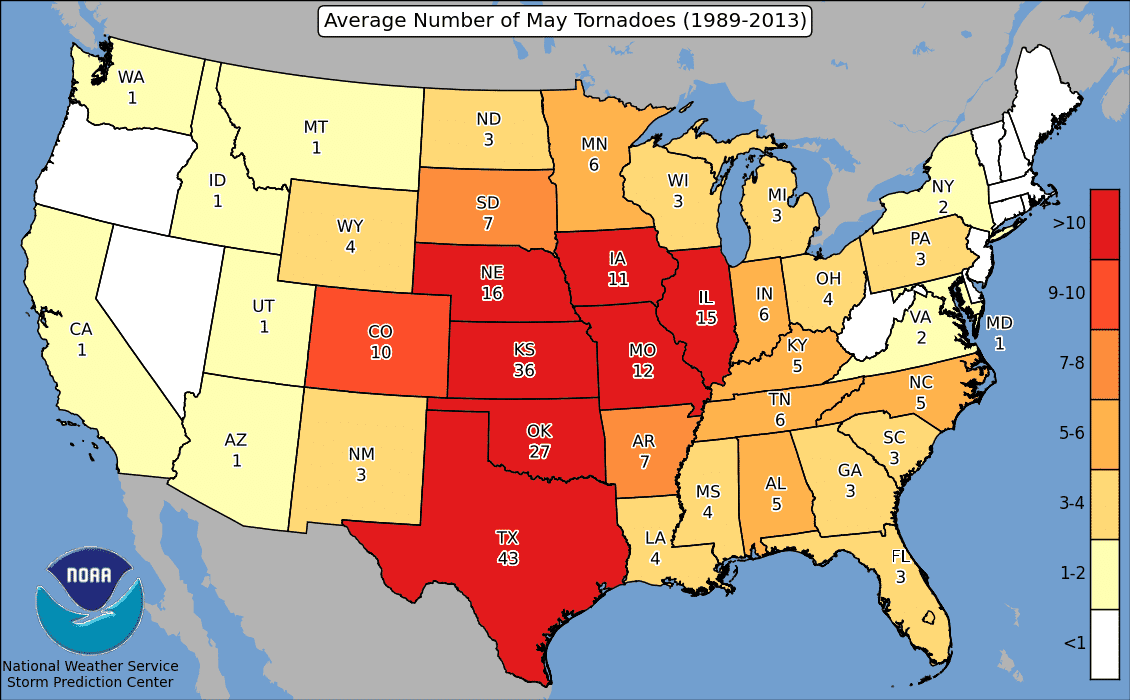
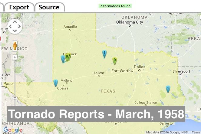
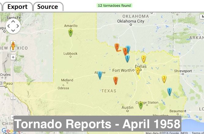
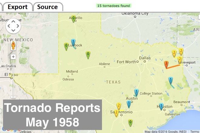
What about storms and tornadoes? For that, we have to dig back into historical data for the spring of 1958 once again…as that appears to be the past El Nino event we are most aligned with currently. On average during the months of March, April and May, Texas sees an average of 11, 29 and 43 tornadoes respectively. During the Spring of 1958, it was noted that we had fewer than average tornadoes reported across the state. A total of 7 were reported in March, 12 in April and only 15 in May. Now, keep in mind that current technology has allowed us to record tornado sightings with greater accuracy than we had back in 1958, so there could be a few missing…but that’s still a notably small number of reports.

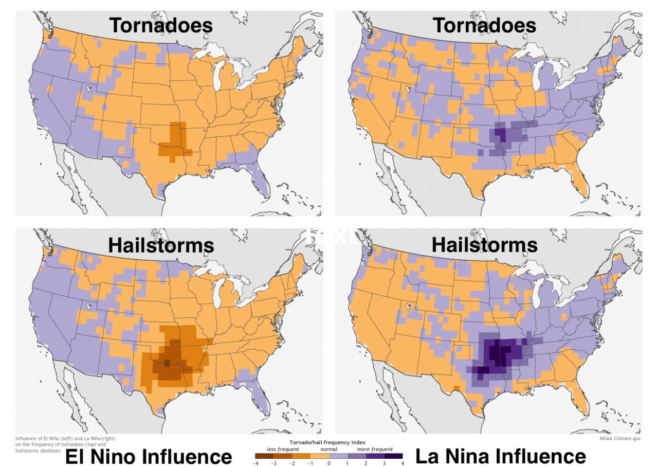
The natural assumption based on the data above would be that Spring weather patterns coming out of an El Nino winter do a lower than average number of tornadoes. This assumption is supported based on recent scientific research as well. A paper published in Nature Geoscience in April of 2015 by climate scientists/researchers John Allen, Michael Tippett and Adam Sobel, draws the conclusion that there tends to be a decrease in the amount of severe storms producing tornadoes and hail during El Nino springs. The reason for this is tied to the position of the subtropical jetstream typically identified with each type of pattern. Typical El Nino patterns for the spring season tend to alter and weaken the surface winds that bring Gulf moisture up over our state. This is more of a setup for just general rain showers than severe weather. On the other hand, a typical La Nina pattern would tend to concentrate more hot and humid air over our region which is generally more favorable for storm formation. Should we expect to see fewer tornadoes and severe weather this coming spring? Since this is relatively new research, more time and study is needed to determine if there really is a clear-cut answer to that question.
In conclusion, the fact that we’ve been relatively dry this winter does not preclude a chance for transitioning into a wetter than average pattern this spring. And while past research indicates a lower frequency of tornadoes and severe weather during El Nino springs, there is insufficient evidence that we definitely will see a less active Spring this year.
Links to source data:
http://www.ncdc.noaa.gov/temp-and-precip/us-maps/1/201601?products[]=statewidepcpnrank
http://www.srh.noaa.gov/fwd/?n=climateoutlook
https://www.ncdc.noaa.gov/temp-and-precip/drought/historical-palmers/psi/195801-195805
http://www.spc.noaa.gov/wcm/permonth_by_state/May.png
http://www.tornadohistoryproject.com/tornado/Texas/1958/May/map


0 Comments