

For the first time in nearly two years we have an extremely critical fire weather designation for portions of Texas. That extremely critical fire weather designation includes the Texas Panhandle. A critical fire weather risk includes the South Plains, Rolling Plains, Far Northwest Texas, and the northern Permian Basin. An elevated/near-critical risk zone runs southeast into the Big Country, Concho Valley, Northwest Texas, and North Texas. Any grass fire that develops could spread quickly nearly anytime across all of Texas. These outlooks are meant to highlight the combination of winds, temperatures, and humidity levels that would promote a greater fire risk. We note that the last time we had an extremely critical fire weather risk in Texas was back in 2014. We will have an extremely dangerous risk of wildfires on Thursday but that is not a guarantee of high-impact fires. It takes a spark to create a fire. Hopefully folks will be cautious enough that we can get away without any major incidents. One concern will be the gusty winds across the extreme and critical risk zones since those winds could cause a few power lines to arch. While not shown graphically the fuel load is quite high across Texas. All the rain last spring and fall created plenty of vegetation. That vegetation went dormant for the winter and is now very dry. An interesting aspect is that the soil itself is still soft which makes it more difficult for firefighters to get their rigs out there.
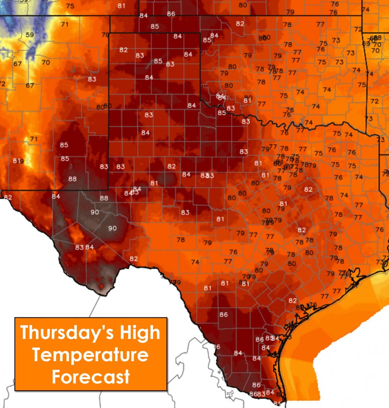
One reason for the very high fire danger on Thursday is record heat. The Texas Panhandle, South Plains, Rolling Plains, Northwest Texas, Big Country, Concho Valley, and Permian Basin will top out in the middle 80s. The western Permian Basin is forecast to top out in the upper 80s to low 90s. Those readings are 20 to 35 degrees above average for the middle of February. All of Texas will be above-average and warm but the record heat will be across the regions mentioned above. Southwest and southerly winds will be noticeable on Thursday across all of Texas. The strongest winds will be across the Texas Panhandle and West Texas with gusts up to 30-35 MPH. Relative humidity values will plummet as temperatures rise on Thursday. The lowest humidity values will be across the Texas Panhandle where we could see values drop down to 5-8 percent. RH values below 20 percent are expected across the Rolling Plains, South Plains, Permian Basin, and Northwest Texas. Slightly higher relative humidity values of 20-30 percent will be noted across the Big Country, Concho Valley, and North Texas. Those slightly higher values could be partially offset by the high fuel load of dormant grass.
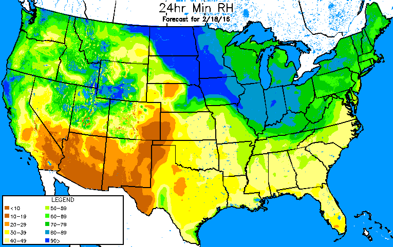
Forecast minimum relative humidity values on Thursday afternoon.
Red Flag Warnings and Fire Weather Watches are in effect for the Texas Panhandle, South Plains, Rolling Plains, Northwest Texas, Big Country, and western North Texas. Those will likely all be upgraded to Red Flag Warnings on Thursday morning. Tomorrow is the kind of day where we could get high-impact, fast moving wildfires. Likewise if folks behave and perform no outdoor burning we hopefully will get away without any issues. If you live in an area susceptible to wildland fires there are a few tips I would recommend. Understand where you would go if you needed to evacuate your residence. Have an escape route that allows you to quickly exit the area. Keep an eye out for smoke and act quickly if needed. Fires could move extremely rapidly tomorrow and thus situational awareness will be key.


0 Comments