
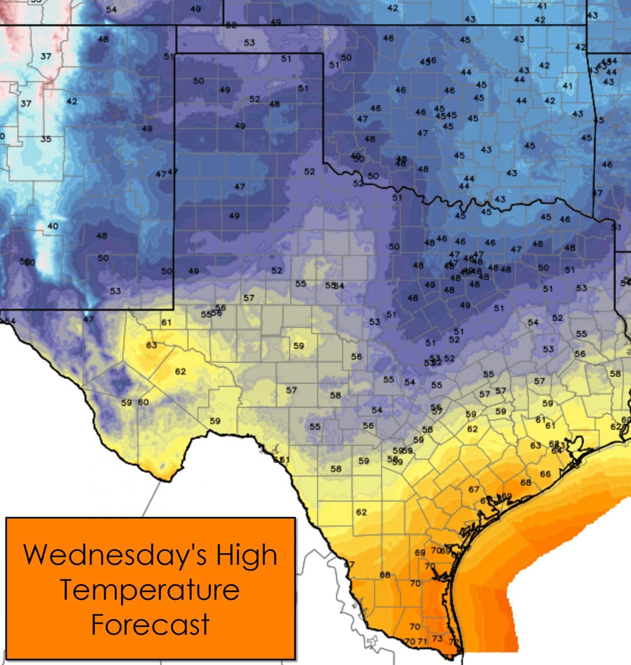
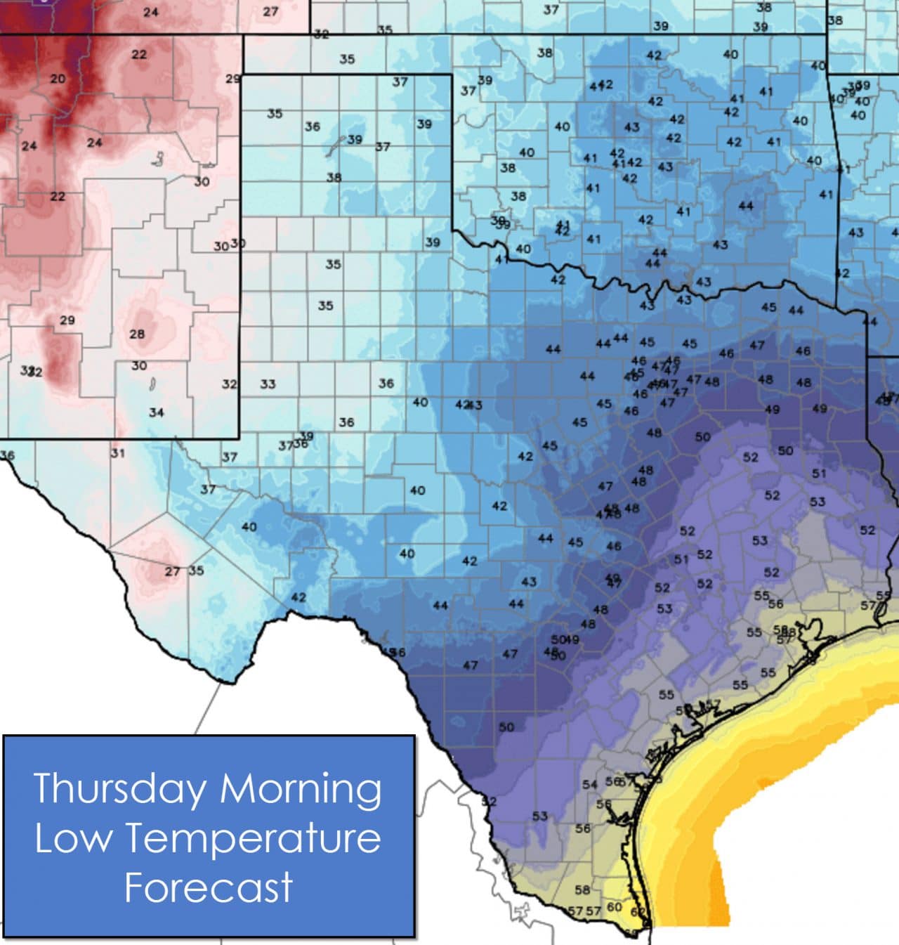
Temperatures will be quite nice in the Rio Grande Valley, South Texas, the Coastal Plains, and for folks relatively near the coast in Southeast Texas this afternoon with 60s to low 70s. 50s to 60s are expected in the Hill Country, Concho Valley, and the Permian Basin. Upper 40s to low 50s can be looked forward to in the Panhandle and West Texas. Cooler air seeping south from Oklahoma will keep Texoma, North Texas, and Northeast Texas in the upper 40s this afternoon – a rather dreary day in store. Temperatures tonight will remain above freezing for all of Texas except those in the higher elevations like around Alpine. 40s and 50s can be expected for the eastern two-thirds of Texas while the western third of the state drops down into the mid and upper 30s.
It won’t be raining all day nor will it be raining everywhere. What we will see across most of Texas is cloudy skies today and tonight. Showers will increase in coverage this afternoon along and east of Interstate 35. Scattered light rain will be ongoing across the Permian Basin, Big Country, and Northwest Texas through this afternoon. Rain amounts will remain light west of Interstate 35 with most locations receiving under a quarter inch of rain. East Texas and Southeast Texas will likely see a larger area of moderate rain this evening and tonight. The atmosphere will be fairly stable so widespread thunderstorms aren’t likely. Three-hourly rain totals may approach half an inch in some locations. Overall rain accumulations could end up between half an inch and one inch along and east of Interstate 35 from the D/FW Metroplex south through Austin and San Antonio into the Brazos Valley, East Texas, and Northeast Texas. . Slightly higher rain totals around an inch may occur across Southeast Texas and locations closer to the coast.
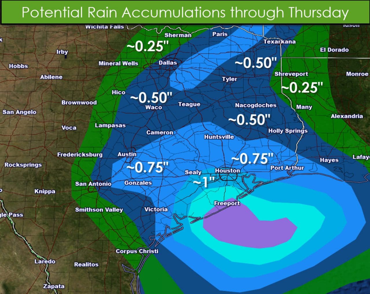
A good chunk of the rain will fall over a period of six to twelve hours. Rain totals will be light enough to preclude a widespread flooding risk. I can’t rule out a few minor issues in typical trouble spots – but this won’t be more than a steady rain. A few lightning strikes will be possible but severe weather is extremely unlikely. Temperatures will be well above freezing and no frozen precipitation is expected. Rain should move east of Texas by late Thursday morning just in time for a warm Thursday and Friday.
Above-average temperatures will return to Texas for Thursday and Friday before our next cold front brings a return of winter. Temperatures on Thursday will peak in the 60s and 70s along and south of Interstate 20 from the 10/20 split all the way to the eastern border of Texas. Midland will peak around 63, Abilene at 65, Texarkana at 60, Lufkin and San Angelo at 68, Laredo and Brownsville at 73. Folks in the Panhandle and South Plains – who have dealt with cold weather since late December – will even get a brief reprieve of winter with high temperatures in the mid 50s. Temperatures will be a bit cooler for those folks on Friday as a cold front starts pushing south but the warmer temperatures will continue for folks along and south of Interstate 20. A strong cold front will bring much more seasonal temperatures back into Texas by the weekend. Enjoy the warm weather while it lasts! The weekend cold front will be dry with no issues expected in the winter weather department. We may have a few shots at light winter precipitation next week but nothing close to what snow lovers are looking for.


0 Comments