
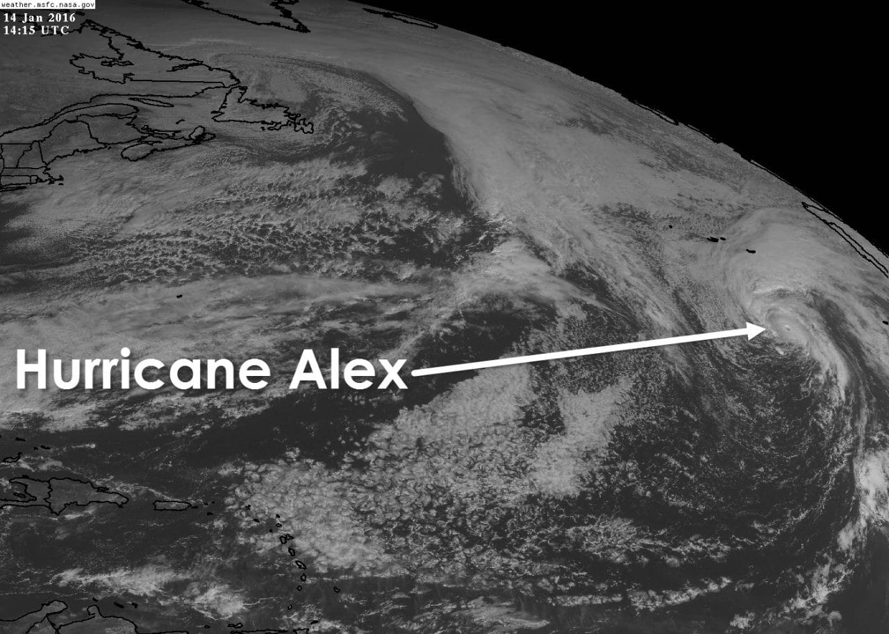
Relish this meteorological event for it does not happen often. A hurricane has formed in the Far Eastern Atlantic during the month of January. The last time this occurred was all the way back in January of 1938. Alex is located 490 miles south of Faial Island in the Azores and will bring them hurricane-force winds on Friday. This storm is not necessarily an indication that we’re going to have an active hurricane season this summer. The system should lose tropical characteristics on Saturday as it becomes a powerful extratropical low.

HURRICANE ALEX ADVISORY NUMBER 4
NWS NATIONAL HURRICANE CENTER MIAMI FL AL012016
1100 AM AST THU JAN 14 2016
…ALEX BECOMES A HURRICANE…
…HURRICANE WARNING ISSUED FOR THE AZORES…
SUMMARY OF 1100 AM AST…1500 UTC…INFORMATION
———————————————–
LOCATION…31.5N 28.4W
ABOUT 490 MI…790 KM S OF FAIAL ISLAND IN THE CENTRAL AZORES
MAXIMUM SUSTAINED WINDS…85 MPH…140 KM/H
PRESENT MOVEMENT…NNE OR 20 DEGREES AT 20 MPH…31 KM/H
MINIMUM CENTRAL PRESSURE…981 MB…28.97 INCHES
WATCHES AND WARNINGS
——————–
CHANGES WITH THIS ADVISORY:
The Azores Meteorological Service has issued a Hurricane Warning
for the islands of Faial, Pico, Sao Jorge, Graciosa, and Terceira in
the central Azores, and a Tropical Storm Warning for the islands
of Sao Miguel and Santa Maria in the eastern Azores.
SUMMARY OF WATCHES AND WARNINGS IN EFFECT:
A Hurricane Warning is in effect for…
* Faial, Pico, Sao Jorge, Graciosa, and Terceira in the central
Azores
A Tropical Storm Warning is in effect for…
* Sao Miguel and Santa Maria in the eastern Azores
For storm information specific to your area, please monitor
products issued by your national meteorological service.
DISCUSSION AND 48-HOUR OUTLOOK
——————————
At 1100 AM AST (1500 UTC), the center of Hurricane Alex was located
near latitude 31.5 North, longitude 28.4 West. Alex is moving toward
the north-northeast near 20 mph (31 km/h) and a turn toward the
north with an increase in forward speed is expected over the next
day or two. On the forecast track, the center of Alex will move
near or over portions of the Azores Friday morning.
Maximum sustained winds are near 85 mph (140 km/h) with higher
gusts. Little change in strength is forecast through Friday.
Hurricane force winds extend outward up to 25 miles (35 km) from the
center and tropical storm force winds extend outward up to 150 miles
(240 km).
The estimated minimum central pressure is 981 mb (28.97 inches).
HAZARDS AFFECTING LAND
———————-
WIND: Tropical-storm-force winds are expected to begin over
portions of the Azores tonight. Hurricane conditions are expected
to spread over the central Azores by early Friday.
Wind speeds atop and on the windward sides of hills and mountains
are often up to 30 percent stronger than the near-surface
winds indicated in this advisory, and in some elevated locations
could be even greater.
RAINFALL: Alex is expected to produce total rain accumulations of
3 to 5 inches over the Azores through Friday, with possible
isolated maximum amounts of 7 inches. These rains could produce
life-threatening flash floods and mud slides.
STORM SURGE: A dangerous storm surge is expected to produce
significant coastal flooding near and to the east of the center of
Alex. Near the coast, the surge will be accompanied by large and
destructive waves.


0 Comments