
Thunderstorms have quickly developed just northeast of the D/FW Metroplex over the past hour. One of these storms has become severe in southeast Fannin county. That storm will move northeast into Lamar county over the next 45 minutes and potentially impact Paris. Another strong storm is in western Hunt County and is increasing in organization. Strong wind shear is in place and the atmosphere is unstable. Based on recent thunderstorm development the severe weather threat for Northeast Texas appears to be increasing this morning. Additional thunderstorms may develop further south or just east of the D/FW Metroplex over the next two hours. Any new storms that develop will also move northeast and impact Northeast Texas this morning. Large hail and damaging wind gusts are the main threat currently – but the tornado threat may increase over the next few hours. A tornado watch is in effect for Northeast Texas through 7 AM and that will likely be extended to around lunchtime. Those in Northeast Texas should remain weather aware this morning now that we actually have thunderstorms underway. One easy way to keep up with the storms is to use our free interactive weather radar. You can find it by clicking the ‘radar’ banner at the top of this page.
The Storm Prediction Center just issued a mesoscale discussion that indicates the increasing severe weather potential this morning for Northeast Texas. While some of it may be technical in nature I have included the full discussion here for you to read.
NWS STORM PREDICTION CENTER NORMAN OK
0439 AM CST WED DEC 23 2015
AREAS AFFECTED…NORTHEASTERN TEXAS…FAR SOUTHEASTERN
OKLAHOMA…WESTERN AND CENTRAL ARKANSAS…AND NORTHWESTERN LOUISIANA
CONCERNING…TORNADO WATCH 556…
VALID 231039Z – 231245Z
THE SEVERE WEATHER THREAT FOR TORNADO WATCH 556 CONTINUES.
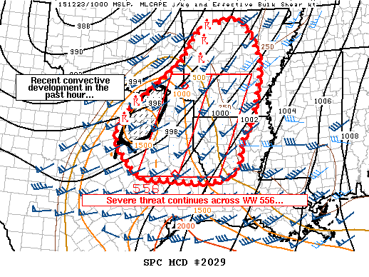
SUMMARY…THE SEVERE THREAT IN AND NEAR WW 556 CONTINUES…WITH
ADDITIONAL CONVECTIVE DEVELOPMENT NEAR/NORTH OF THE DALLAS METROPLEX
EXPECTED TO MOVE INTO THE WATCH AREA OVER THE NEXT HOUR.
HAIL…WIND…AND TORNADOES ALL REMAIN POSSIBLE THROUGH AT LEAST
1300 UTC.
DISCUSSION…MUCH OF THE CONVECTION INITIALLY IN WW 556 HAS MOVED
OUT OF THE WATCH AREA THIS MORNING…YIELDING A RELATIVE LULL IN
ACTIVITY OVER THE PAST HOUR OR TWO. HOWEVER…NEW CONVECTION HAS
DEVELOPED NEAR/NORTH OF THE DALLAS/FORT WORTH METROPLEX…LIKELY
ASSOCIATED WITH FORCING FOR ASCENT OVERSPREADING THE WESTERN FRINGE
OF THE WARM SECTOR IN THAT AREA. MODELS/OBSERVATIONS SUGGEST THAT
THIS CONVECTION WILL CONTINUE TO EXPAND WITH TIME…AND WILL POSE A
HAIL/WIND AND TORNADO THREAT AS THIS CONVECTION MOVES EASTWARD INTO
THE WATCH AREA. GIVEN CURRENT CONVECTIVE TRENDS…A WESTWARD
SPATIAL EXTENSION OF THE WATCH MAY BE NECESSARY TO ADDRESS THIS
THREAT.
CONVECTION JUST NORTH OF THE WATCH /IN WEST CENTRAL AND NORTHWEST
ARKANSAS/ HAS ORGANIZED INTO BROKEN LINE SEGMENTS AND PRODUCED
MOSTLY SUB-SEVERE WIND GUSTS THIS MORNING. WITH TIME…INSTABILITY
SHOULD GRADUALLY INCREASE AS A RESULT OF CONTINUED LOW-LEVEL
WARM/MOIST ADVECTION…WITH AN ATTENDANT INCREASE OF WIND GUSTS AND
PERHAPS A TORNADO OR TWO ALSO POSSIBLE. TRENDS WILL CONTINUE TO BE
MONITORED…AND LOCAL EXTENSIONS AND/OR A NEW WATCH MAY BE NEEDED
FOR THAT AREA WITHIN THE NEXT TWO HOURS.


0 Comments