
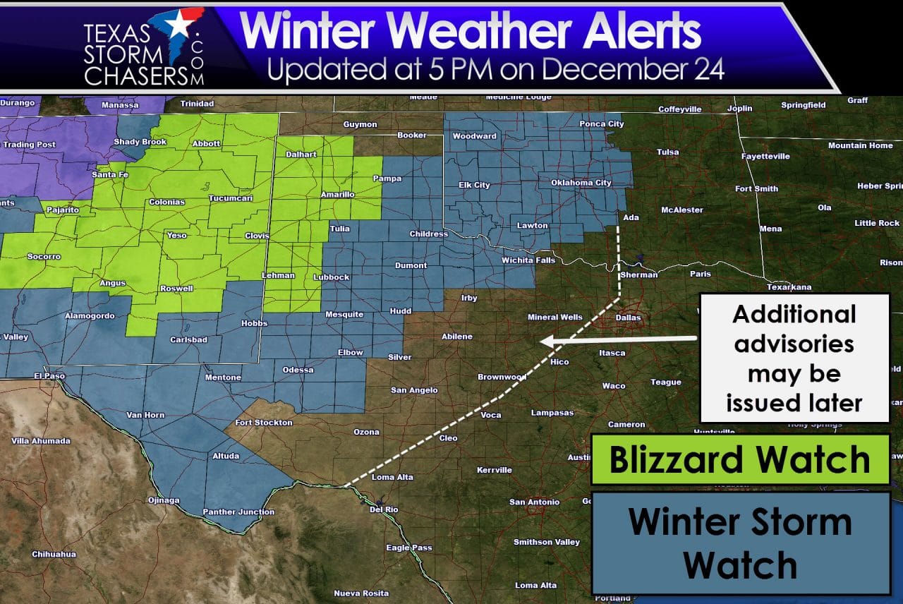
Summary: A Blizzard WATCH has been issued for the western Texas panhandle and for portions of the central Texas panhandle in effect Saturday evening through early Monday. A Winter Storm WATCH has been issued for the central, southern and eastern portions of the Texas panhandle, portions of northwest Texas, portions of the south plains and most of west Texas beginning Saturday evening and continuing through late Sunday into Monday morning. A WATCH simply means dangerous winter weather conditions are possible in the near future, and residents in the area are urged to make plans now to protect family, property and pets/livestock.
The Blizzard WATCH : Once the winter storm arrives by Saturday afternoon and throughout Sunday, residents can expect sustained winds between 30 and 40mph with gusts exceeding 50mph with heavy blowing snow which could reduce visibilities to near zero at times. Wind chills are also expected to drop below zero across the area. Travel will become extremely dangerous across the region on Sunday and is highly discouraged. TXDot operations will be doing their best to keep the roads clear, but understand that these conditions will make it impossible at times for plows and salt trucks to maintain the roads. Many roads are expected to be closed for the duration of the event…this includes major interstates across the area…I-40, I-27, etc. If you must travel, carry a winter survival kit with you. If you get stranded, help will not be immediate and you’ll likely be spending the night wherever your vehicle ends up at.
The Winter Storm WATCH: A wintry mix of sleet, freezing rain and snow is likely to being by Saturday evening eventually changing over to all snow by early Sunday. Northerly winds of 30 to 40mph with gusts exceeding 50mph are likely and will result in periods of blowing snow and near blizzard conditions. Sleet and ice accumulations are expected to remain low…generally 1/4 inch…as temps will be rapidly dropping down to freezing once the front blows through. Snowfall accumulations will vary from area to area, but general expectations widespread 6 inch accumulations with some areas seeing 12+ inches is likely. Blowing snow will pile up and cause even higher drifts along the north/northwest sides of structures and road embankments. Travel across the Winter Storm Watch area is also expected to become hazardous and extremely dangerous for the duration of the event. Stay off the roads if at all possible. Again, TXDot operations will be doing their best to keep the roads clear, but understand that these conditions will make it impossible at times for plows and salt trucks to maintain the roads. Many roads are likely to be closed from time to time for the duration of the event…this includes major interstates across the area…I-40, I-27, portions of I-20 from Midland westward. Bridges and overpasses will become slick. If you must venture out for work or other obligations, be sure to carry a winter survival kit with you. If you get stranded, expect long delays before help can reach you.
Please continue to check back with us for the latest updates as we get closer to the event. With the system still a few days out, we could still see some changes to the track and intensity of the storm which could alter the current set of Watches…including a further eastward expansion.


0 Comments