
Just wanted to get the latest updates out on the significant winter storm expected to impact parts of the Texas panhandle and rolling plains beginning late Thursday and continuing into early Saturday. As mentioned in several of our recent blogs, a strong Canadian front will blast through the state early Thursday into Friday. Along and ahead of the cold front, abundant rain and a few strong storms will develop out ahead of an upper level disturbance which is expected to sit and spin over the desert southwest for a few days before ejecting off to the northeast. Enhancing the threat of rain will be a fetch of tropical moisture carried up and over the state from the remnants of Hurricane Sandra once she makes landfall on the southern Baja coast by Saturday. Definitely an unusual late fall setup, and one that will bring many impacts to the panhandle and parts of the rolling plains. Below we have a graphic with the latest Watches and Warnings that have been posted as of this blog update. We’ll discuss the winter mess first, then dive into the flooding threats later in the blog.
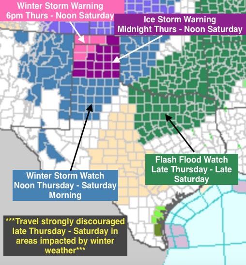
The NWS office in Amarillo has issued a Winter Storm Warning and Ice Storm Warning for their forecast area beginning late Thursday and ending by Noon Saturday. For the northwestern tier of counties in the panhandle, rain is expected to transition over to freezing rain and sleet by Thursday evening with ice accumulations of 1/10 to 1/25 inch, and sleet accumulation between 1 to 3 inches. On top of that, snow accumulations of 1 to 3 inches is also possible. For the counties included in the Ice Storm Warning, rain is expected to transition over to freezing rain by Thursday night with freezing rain expected to continue on and off through early Saturday. Ice accumulations up to 1/2 inch, with isolated higher amount, are likely. TRAVEL IS STRONGLY DISCOURAGED THROUGHOUT THE TEXAS PANHANDLE REGION BEGINNING LATE THURSDAY THROUGH EARLY SATURDAY. If you don’t absolutely have to be out, stay put and wait until roads have cleared. Plan on making other arrangements if you anticipate having to travel through this region to your ultimate destination. Please remember that if you get stuck on the ice somewhere, some poor soul will have to come rescue you putting their safety in jeopardy as well.

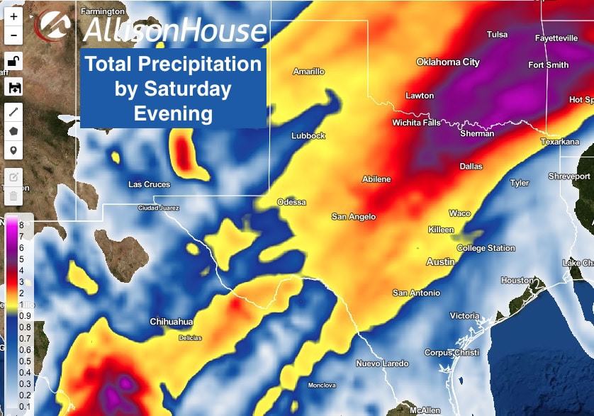
Widespread rainfall is expected to impact parts of northern Texas beginning Thursday and lasting through Sunday. Even with this being a multi-day event, which typically allows the rain to soak in and lessen the threat for flooding, recent rain has kept our soils fairly damp across northern Texas and it won’t take much to create flooding issues. The bulk of the rain is expected to fall north of the I-20 corridor late Thursday, Friday and through Saturday Accumulations up to 7 inches are likely, especially in the Red River counties just north of the Dallas/Ft Worth metroplex. Winter weather is NOT expected for north Texas or the DFW Metro. Our temps across north Texas will be flirting with the freezing level, but the air above us…above the shallow layer of cold air…will be much too warm to support the development of ice or snow. Nevertheless, the rain and potential flooding will present travel challenges, especially Friday night through Saturday. If you have to get out and about, just plan on taking extra time to reach your destination.
We typically do not provide detailed information on road conditions or closures during major events, but TXDot has a wonderful interactive map which they keep updated during these winter weather events. Bookmark their page at http://drivetexas.org/.


0 Comments