
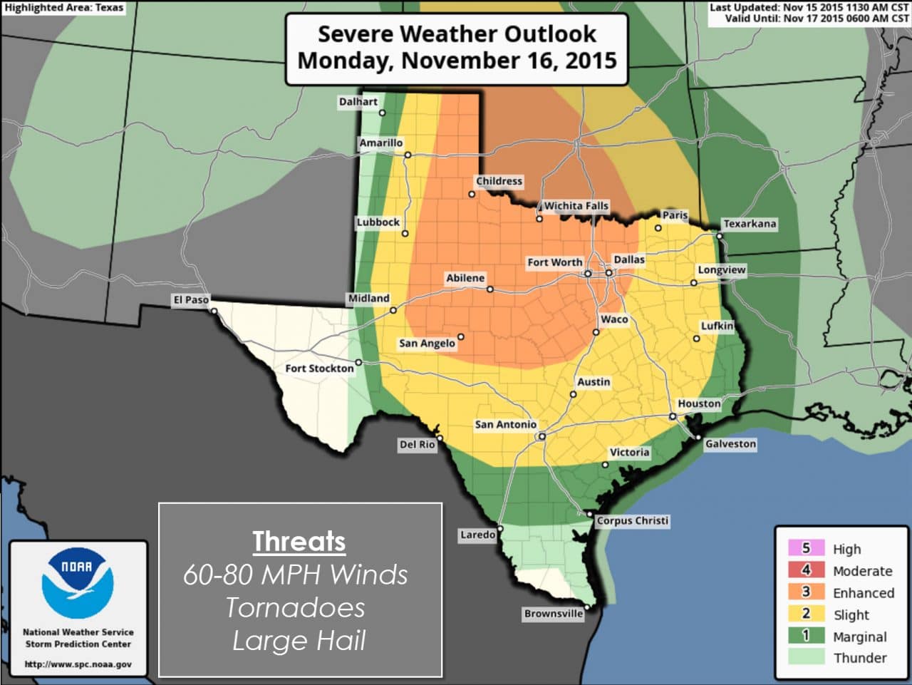
A severe weather outbreak is possible beginning Monday Evening and continuing all night into Tuesday. This setup has another dangerous factor in that it will be a nighttime event. The Storm Prediction Center has greatly expanded the Category 3/Enhanced Risk zone to include Northwest Texas, the Big Country, Concho Valley, and North Texas. This enhanced risk zone is where we’re most concerned about the threat of widespread damaging straight-line wind gusts. Considering how strong the winds aloft are I wouldn’t be surprised to see a few wind gusts exceed 75 MPH. Likewise strong wind shear will also mean a tornado threat all night. I encourage you to check back for forecast updates and to have a way to receive severe weather warnings tomorrow night. Scroll to the bottom of this blog for safety tips.
…SUMMARY…
SEVERE STORMS ARE EXPECTED TO INITIATE ACROSS THE CENTRAL AND
SOUTHERN HIGH PLAINS LATE AFTERNOON TO EVENING ON MONDAY. AN
EXTENSIVE SQUALL LINE SHOULD FORM MONDAY NIGHT AND PUSH EASTWARD
ACROSS PARTS OF OKLAHOMA AND TEXAS. TORNADOES…DAMAGING WINDS…AND
LARGE HAIL ARE ANTICIPATED.
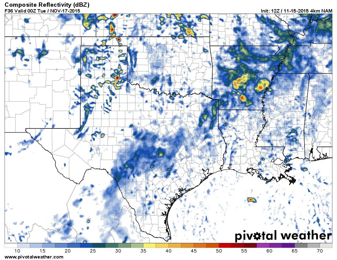
The simulated radar loop included with this post is courtesy of the 4 kilometer North American Model (4KM NAM) run from 6 AM this morning. No weather model gets everything exactly right so don’t expect the radar to literally look like what is shown here. Times on the graphic are in Zulu/UTC. Central Time is six hours back so 00Z would by 6 PM Monday, 03Z 9 PM Tuesday, 06Z is 12 AM Tuesday et al. We expect the first severe thunderstorms to initially develop across the eastern Texas Panhandle and near or just east of the Caprock around 5-6 PM Monday. These initial storms have the potential to be supercellular in an environment supportive of severe weather. Moderate instablity and strong wind shear will combine to produce the threat of golfball size hail, damaging wind gusts over 60 MPH, and the potential for tornadoes. Thunderstorm initiation may hold off right until sunset making this a nocturnal event.

Helicity (amount of spin) in the atmosphere Monday Evening will be quite high.

Surface moisture from the 12Z NAM at 6 PM on Sunday. The west edge of the moisture axis is the leading edge of the dryline.
Strong forcing/lift will cause a line of storms to quickly develop on the Texas Panhandle/Oklahoma border south into the Big Country and Concho Valley by the evening hours Monday. This line will race east into an environment characterised with very strong wind shear and an unstable airmass. A powerful low level jet and a maritime environment will allow the atmosphere to remain unstable all night along and east of the squall line. Unlike the spring months we can see severe weather threats continue all night in the fall/cool season. Winds around 5,000 feet above sea level will be above 70 MPH by midnight Tuesday across Northwest Texas and North Texas. The squall line will have the potential to bring some of that wind to the surface in the form of damaging wind gusts.
Very strong low level windshear means isolated tornadoes are possible within the line as it races east overnight Monday. Widespread wind gusts of 50 to 70 MPH will be the primary threat. Embedded circulations in the squall line may produce isolated tornadoes. Any discrete thunderstorms that form east/ahead of the line could become tornadic due to very strong wind shear. Some hail is also a secondary threat.
Severe weather is likely during the nighttime hours Monday into Tuesday Morning. A line of severe thunderstorms will race east across Northwest Texas, the Big Country, and Concho Valley late Monday Night into early Tuesday morning. The squall line should impact the Interstate 35 corridor from the Red River south into Central Texas between 3 AM and 6 AM with a damaging wind and isolated tornado threat. From there the line will continue moving east with a severe weather threat in Northeast Texas, East Texas, and Southeast Texas. Timing aspects have the potential to change as we get closer to Monday Night.

The threat for severe weather means you should have a way to receive severe weather warnings and have a severe weather safety plan. Know where to go if a warning is issued for your area. Have a plan and you’ll be good to go! The threat for storms is something all Texans live with. Folks in California live with earthquakes and those along the Gulf Coast live with hurricane threats. There is no reason to be fearful of this upcoming event. I was scared to death of storms as a kid – like beyond scared. I dealt with that fear by learning more about weather. Now I chase storms and have a better understanding of the mechanics of severe weather. The chance of a tornado hitting you is tiny. Even a large tornado (which we’re not expecting) is small compared to the size of a county. Have at least two ways to receive warnings, have a safety plan practiced and ready to go, and you’ll be just fine!


0 Comments