
Assuming my rebuild of the website and blog today was a success hopefully you’ll be reading this article without any issues. Its been a long day dealing with technical snafus but lets put that behind us and chat about the weather! An impressive upper level storm system will barrel through the region beginning Wednesday Night before exiting sometime on Friday. This intense short wave trough will not only bring more rain to Texas but we could be dealing with a severe weather threat as well. Texas does have a second severe weather season during the fall months. El Nino typically helps enhance that because we have more active storm systems. We had over a dozen tornadoes with the last system and I’m sure we’ll be facing more severe weather threats this fall into the winter months. For ease of reading and to help prevent me from writing an annoyingly long blog I’ll divide this article up into bullet points.
Timing on Precipitation
An isolated shower or storm will be possible during the day across Southwest Texas but most of the state will remain dry. Rain/storm chances increase Wednesday Night across the Texas Panhandle, South Plains, Permian Basin, Concho Valley, Hill Country, Central Texas, North Texas, and Northeast Texas. Some storms may be severe but we’ll talk more about that in a minute. On Thursday scattered to numerous thunderstorms are expected across the Concho Valley, Big Country, Northwest Texas, North Texas, Central Texas, Northeast Texas, and East Texas. There may be multiple rounds of storms and once again some may be severe. Numerous storms will continue into Thursday Night across South-Central Texas, Central Texas, North Texas, Northeast Texas, East Texas, and the Brazos Valley. Some flooding threat is possible during this timeframe due to saturated soils. Scattered rain chances will continue on Friday across South-Central Texas, Deep South Texas, the Rio Grande Valley, Southeast Texas, and East Texas. Those chances will continue into Friday Night although I’m hopeful activity will be on the lighter side.
Forecast Rain Totals
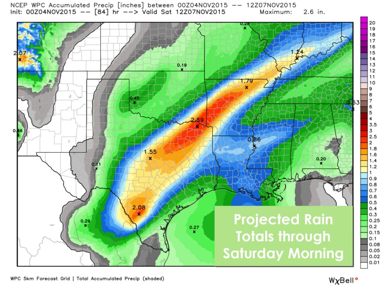
While the upcoming storm system is intense it’ll be booking it along. The end result will be periods of heavy rain but not to the extent we saw the past two events. Rain accumulation forecasts place 1 to 3 inches from the Hill Country and South-Central Texas through North and Northeast Texas by Saturday morning. Localized amounts up to 4 inches will be possible. We don’t anticipate any of the 6-20 inch totals we saw the last two events. Even though rain amounts will be comparatively lower thanks to the fast movement of the storm system we’ll still have to deal with a flash flooding threat. Soils are completely saturated and any additional rains over an inch will likely cause issues. We don’t anticipate any of the major/high-end flooding we saw in Corsicana or in Wimberley with this event.
Severe Weather Threat

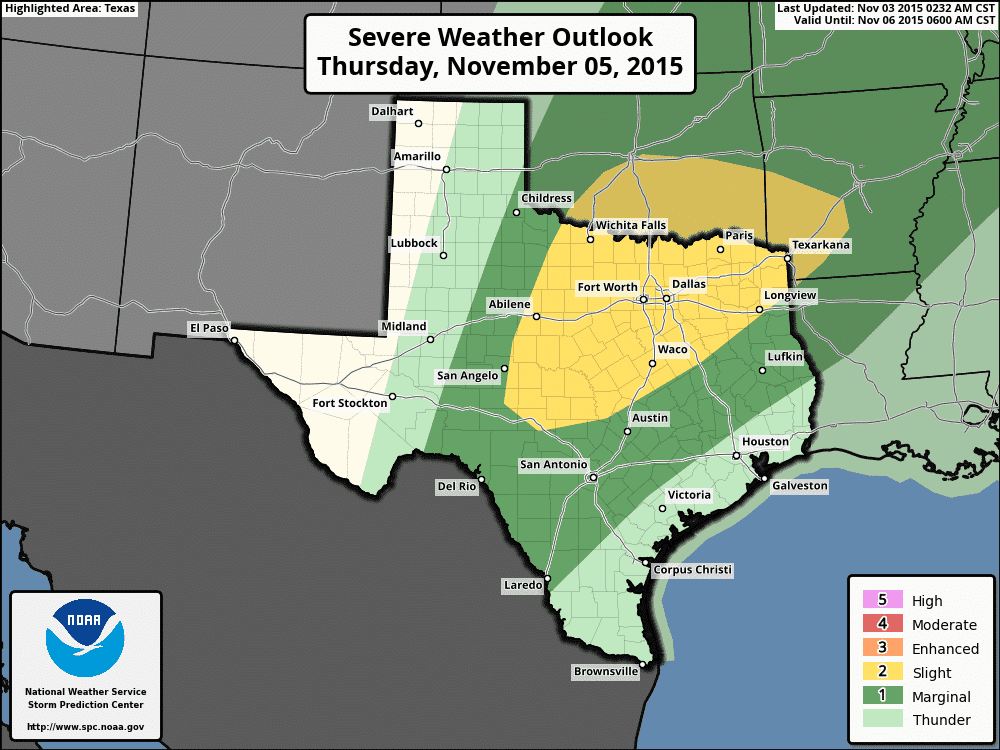
Severe Weather Outlook for Wednesday and Wednesday Night
Severe Weather Outlook for Thursday and Thursday Night
We’re going to be dealing with a very dynamic storm system. Wind shear values will be quite strong. Limiting factors for a major/high-end severe weather event will be widespread clouds and only a marginally unstable atmosphere. Like last week’s event this will be a high shear/low instablity type of setup. The high shear/low instablity setups are what we typically see during our fall/winter severe weather season in the Southern United States. A marginal severe weather risk will likely develop late Wednesday into the morning hours on Thursday across the Texas Panhandle, South Plains, Rolling Plains, into the Permian Basin and Big Country. The strongest storms may be capable of producing quarter size hail, localized damaging wind gusts up to 70 MPH, and a low-end tornado threat. The more impressive severe weather threat looks to set up on Thursday. A category 2/possible severe weather risk has already been issued for the Concho Valley, Big Country, North Texas, Central Texas, Texoma, and Northeast Texas. A category 1/marginal risk includes all of Northwest Texas, South-Central Texas, and East Texas. The overall risk on Thursday will depend on how much rain continues into the early afternoon hours. If the rain lets up and we can get a tad more destabilization in the atmosphere we’ll have to watch for more of a severe weather threat during the afternoon hours. As it is wind shear aloft will be quite supportive of organized thunderstorms. Large hail, damaging straight-line winds, and at least a low-end tornado threat will exist. The threat for severe weather could continue well into the overnight hours Thursday into the predawn hours Friday across Northeast Texas. We’ll be keeping a close eye on this setup and I advise you to do the same.
Summary
Rain is likely for parts of Texas beginning Wednesday Night. Those rain chances will spread east and south on Thursday and into Friday. Rain amounts will be lower than the past two events but localized flooding is still likely where we see the heaviest rains fall or in a short period of time. This upcoming system does look to have a severe weather threat that we’ll need to watch closely. The primary severe weather threat looks to be in the form of damaging wind gusts but large hail and a few tornadoes are also a possibility. If we see the atmosphere destabilize more than expected the threat for severe weather will increase. Likewise more clouds/rain will result in a lower threat of severe thunderstorms. The heaviest rain/storms will move out of Texas by Saturday morning but rain chances along with gloomy weather may continue into the weekend for some.


0 Comments