
It looks like a rain event is going to become a weekly thing in Texas. We had one last week, we’re having one now, and we’re going to have another one next Wednesday through Friday. At least it gives me something talk about besides heat, fire, and drought. Isn’t there a song about that? Anyway with so much going on this morning I’ll divide this blog up into little bullet points to make it easier to read.
Rain Chances
Now through this evening

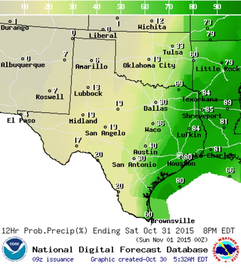
Chance of rain/storms through the late afternoon hours today
The radar is lit up like a Christmas tree this morning across Northwest Texas, North Texas, Central Texas, and South-Central Texas. That’ll continue into the afternoon hours with numerous showers and thunderstorms expected across the Big Country, Concho Valley, North Texas, Central Texas, the Hill Country, and South-Central Texas. Scattered showers and storms are possible across Northeast Texas and the Rio Grande Valley.
Tonight

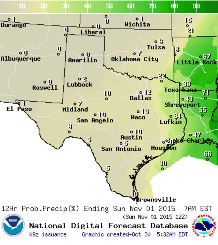
Chance of rain/storms through the late afternoon hours tonight
A nearly 100 percent chance of rain continues tonight across North Texas, Central Texas, South-Central Texas, Northeast Texas, East Texas, and Southeast Texas. D/FW, Waco, Austin, San Antonio, Bryan, Houston, Lufkin, and Texarkana should all get rain at some point tonight. Some rain may be locally heavy with some flooding risk.
Saturday morning through Saturday afternoon
Chance of rain/storms through the late afternoon hours on Saturday morning into the afternoon hours.
Rain chances will start shifting east in a hurry on Saturday. Unlike last week’s event the system responsible for the rain is progressive in nature. That means its in a hurry to boogie on out of here. Only isolated showers are expected west of Interstate 35 during the morning hours before a beautiful day sets up. Folks in Northeast Texas, East TExas, and Southeast Texas will have to deal with showers in the morning hours before things start clearing out by the afternoon.
Saturday evening including Halloween
Chance of rain/storms through the late afternoon hours Saturday evening and Saturday night
The current forecast has only isolated showers still in extreme Northeast and East Texas for Halloween festivities. The rest of the state will be dry and supportive for a fun evening out and about. We got lucky this year for it looks like Halloween won’t be a washout for many locations.
Severe Weather Risk Today
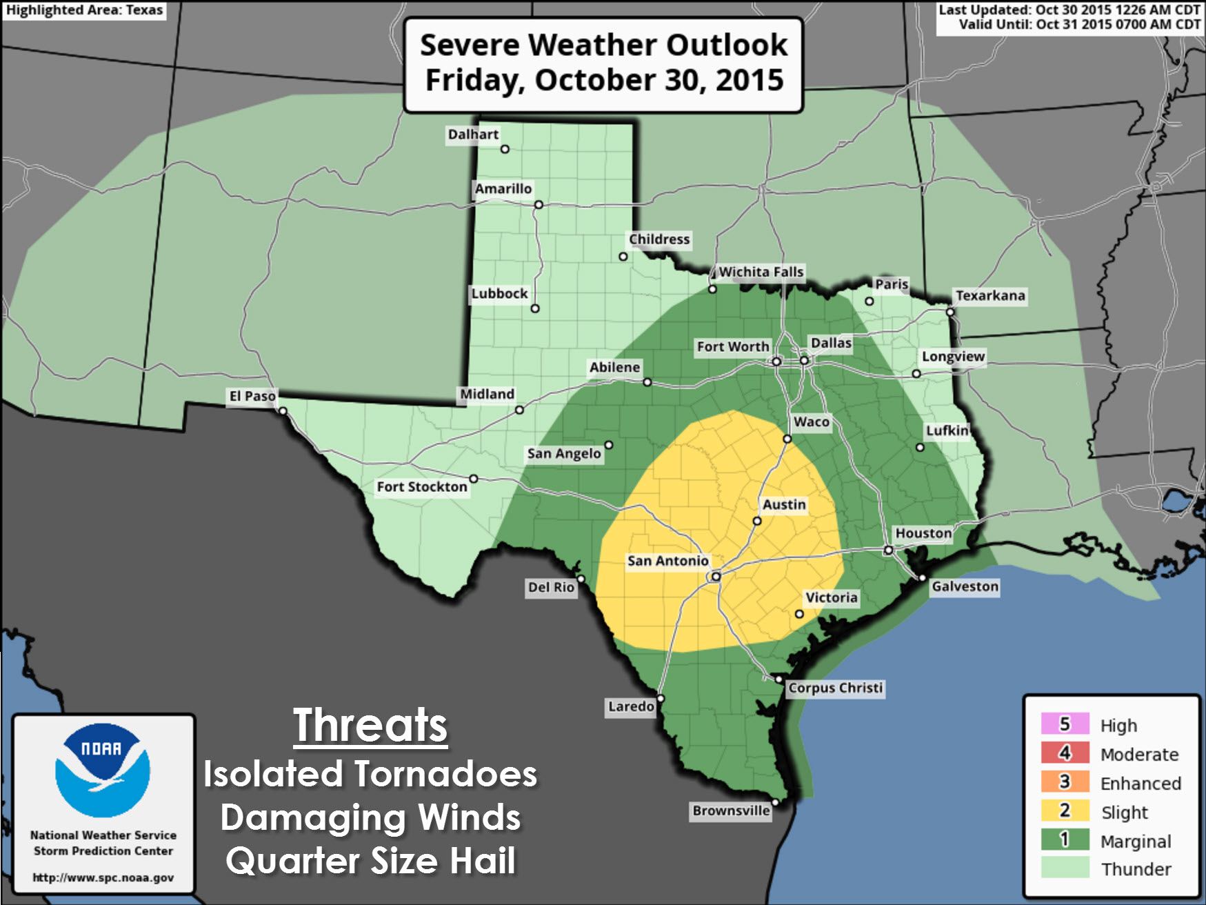
Today’s severe weather setup is a classic cool-season event for Texas. Very strong wind shear is in place and quite supportive of rotating thunderstorms. However the atmosphere is only slightly unstable in most locations. The modestly unstable atmosphere will limit the severe weather threat today – but not eliminate it. In locations where we do manage to see slightly more destabilization or interaction with mesoscale factors we will have to closely watch for rotating thunderstorms. A level 2 possible severe weather risk is in place across Central Texas and South-Central Texas today. Localized damaging wind gusts and a couple of tornadoes are possible.
A tornado watch is in effect for South-Central Texas. Multiple tornado warnings have been issued this morning. Check our homepage at texasstormchasers.com along with our social media feeds for continuing coverage.
Rain totals/flood risk
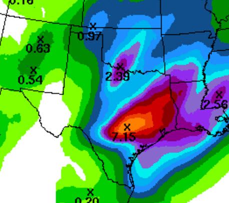
Average rain totals will be 1 to 2 inches today. Some locations will receive over 3 inches and even higher than that. Widespread flash flooding is not expected today but we could have localized issues. Should we get a heavy band to set up over one area we may see enhanced rain totals and more of a significant flooding issue. That prospect is highlighted in this rain forecast from the Weather Prediction Center. I wouldn’t take it to the bank that they have the exact position of that band correct.


0 Comments