
Good Thursday Morning and welcome to our weather blog. We’ve had a lot of new folks visit us over the past couple of days and I wanted to extend them a warm welcome. In the interest of keeping our outgoing information easy to read we’ll once again break things down into bullet points. As always there is an inherent uncertainty in the forecast and thus noting is written in stone. Also a word of caution against using one specific weather model for rain totals. Some are going way overboard with the precipitation totals. With the disclaimers out of the way lets get started!
Right Now and This Morning

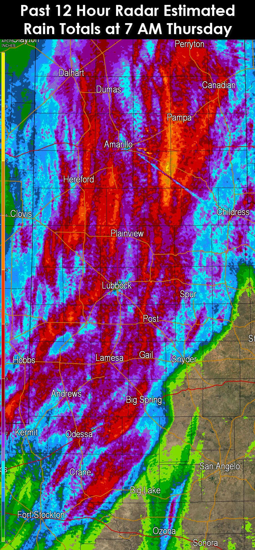
A solid line of showers and thunderstorms is making slow eastward progress across Northwest Texas and western sections of the Big Country and Concho Valley. Shortly after 6:30 AM the leading edge of the rain extended from near Vernon south to Aspermont, Sterling City, to Big Lake, and Iraan. Some storms in this line are strong and capable of producing strong wind gusts. The storms are also producing very heavy rain resulting in several flash flood warnings overnight in the Permian Basin. Radar-estimated rainfall totals overnight show the Texas Panhandle, South Plains, and Permian Basin got a good dose of rain. Some locations picked up too much rain in a short period of time resulting in flash flooding. The Panhandle and West Texas will dry out as rain is now moving east of those areas.
Day by day rain chances
Today and Tonight
I want to preface this by saying although the rain chance map makes today look like a washout for I-35 most activity will be very light. We’re expecting the band of showers/storms across Northwest Texas, the Big Country, and the Concho Valley to make slow east proress today. At some point this afternoon it may cease eastward movement and stall out across the areas mentioned above. Should it slow or stall that would result in an enhanced flood risk for areas it sits over. Rain chances will be highest tonight across Northwest Texas, western North Texas, the Big Country, Concho Valley, Central Texas, and South-Central Texas. The heaviest rains should remain west of I-35 until near dawn on Friday.
Friday and Friday Night
On Friday rain/storm chances become very high for North Texas and western parts of Central Texas into the Concho Valley. Scattered activity is possible across Central Texas, South-Central Texas, the Rio Grande Valley, and back up in Northeast and East Texas. Heavy rain and strong storms will be possible in spots. By Friday Night widespread showers/storms are expected across the Hill Country, Central Texas, North Texas, Northeast Texas with scattered to numerous showers/storms across South-Central Texas and the Rio Grande Valley.
Saturday and Saturday Night
Compared to yesterday’s forecast we have seen some changes for Saturday. Timing has slowed a little which will result in continued high to very high rain/storm chances across North Texas, Northeast Texas, Central Texas, South-Central Texas, and the Rio Grande Valley during the day on Saturday. This is also when we’ll finally see activity push into East and Southeast Texas. Outdoor activities are in danger of being rained out. High rain chances continue Saturday Night across East Texas, Southeast Texas, South Texas, and the Rio Grande Valley. Activity will start to push east with scattered showers continuing along the Interstate 35 corridor.
Sunday and Sunday Night
We should be mostly done with the heavy rain by Sunday. Still we could see scattered showers across East Texas, Southeast Texas, coastal regions, and the Rio Grande Valley with isolated activity continuing into the overnight hours on Sunday.
Rainfall Accumulation and Flooding Potential
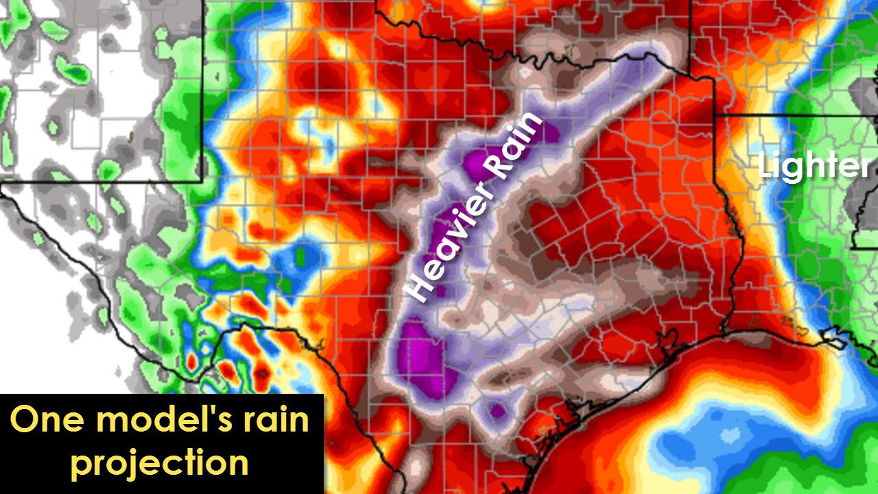
Moisture levels across the state and during the ongoing/upcoming precipitation event will be in the 98th to 99th percentile. The atmosphere has a lot of moisture in it and thus we can see a lot of rain if someone gets a heavy storm stalling out over them. I continue to anticipate widespread 1 to 5 inch rain totals across the state. Those rain totals have been observed across the Panhandle and West Texas into the Permian Basin this morning. On Friday and Saturday its possible that an enhanced band of rain may form and ‘train’ over some locations in North Texas into western Central Texas. Should we see training convection there is the potential for enhanced rainfall totals exceeding 7 to 10 inches in very isolated spots. That is where the threat for flash flooding would be highest. I cannot accurately tell you where that band and thus the super heavy rain totals may fall right now. Realistically that’s something we won’t be able to determine until we’re within 12-18 hours. Most locations will be able to absorb 3 inches of rain before any sort of issues begin since we’ve been so dry. Major widespread flooding is not expected. We could easily see widespread minor/nuisance flooding with streams/creeks running high. Localized more significant issues may occur where the heaviest rains fall through Sunday.
Here is an example of one model attempting to show the training effect on rain totals.
Severe Weather Potential Today
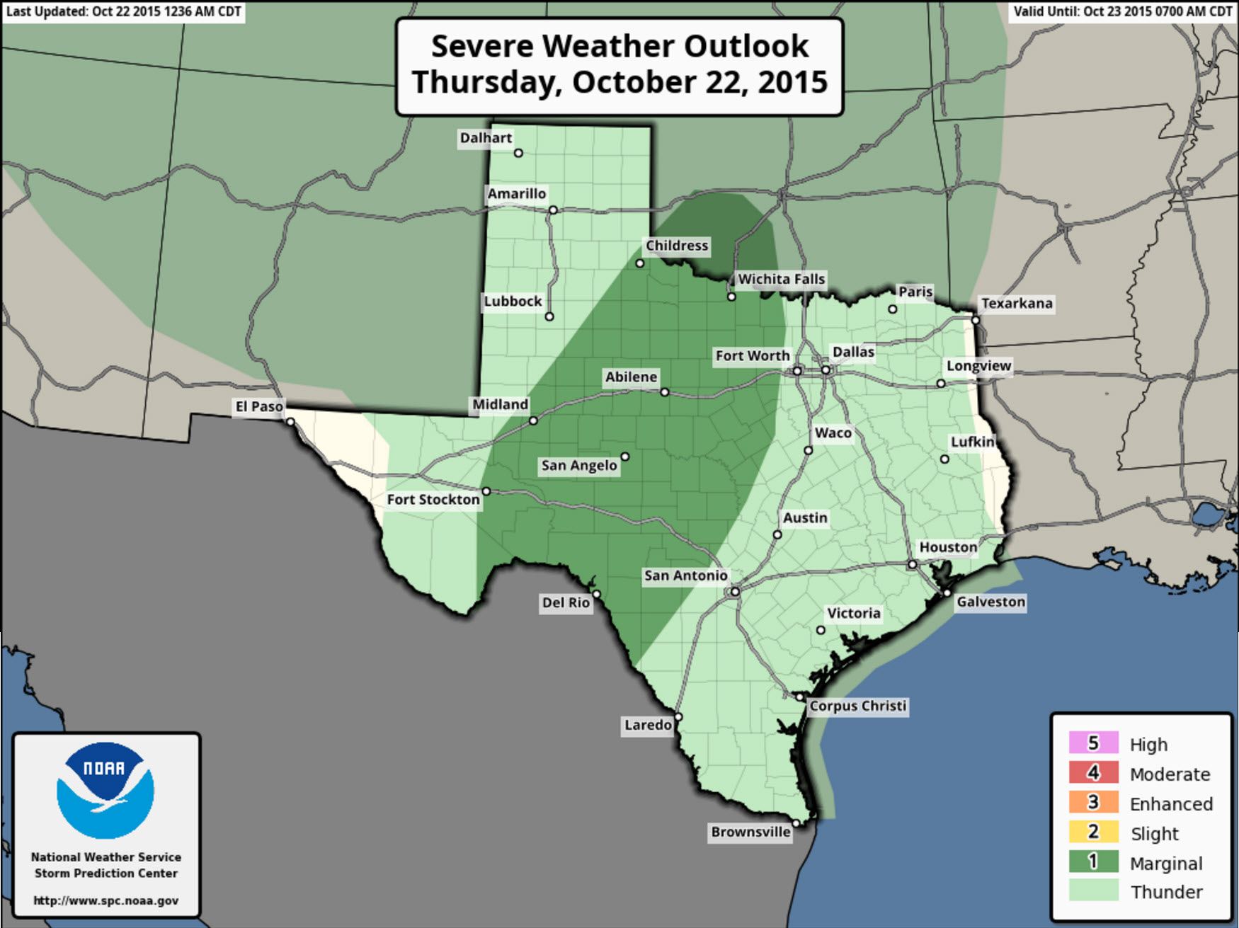
Today’s severe weather setup can be described as a high shear/low instablity event. During the fall and winter months dynamic weather systems usually have a ton of wind shear. Usually the atmosphere is only marginally unstable and thus keeps the severe weather threat marginal/limited. That will be the case today as widespread clouds keep the atmosphere from destabilizing much. A category 1 marginal severe weather risk is in place for Northwest Texas, western North Texas,the Big Country, Concho Valley, and Southwest Texas in addition to Southwest Oklahoma. Widespread severe weather is not expected today and tonight. A few severe storms can’t be ruled out with localized damaging wind gusts, quarter size hail, and even a brief spin up tornado.


0 Comments