
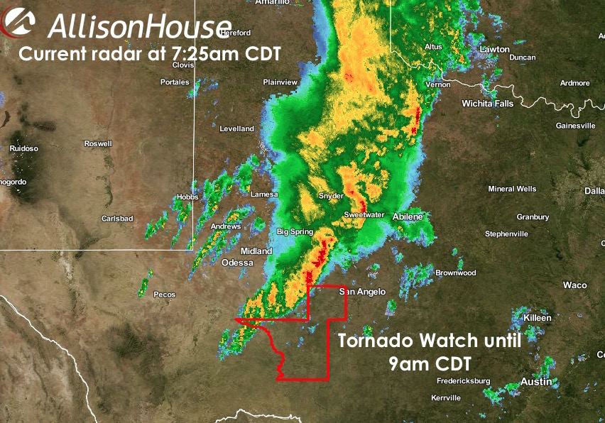
Overnight, a large squall line of strong to severe storms developed across the panhandle and western TX which has moved east into the eastern panhandle and down into western north Texas overnight. While the overall tornado threat is very low, a few spin-ups are possible along the leading edge of the squall line as it advances east this morning across the eastern Permian Basin and Big Country. Regardless of any low chances for tornado development, the greatest threat through the morning hours will be gusty winds in excess of 50mph along the leading edge of the squall line, and very intense rainfall just behind it. Flash flooding is a distinct possibility, especially for areas that are typically flood prone to begin with. We’ll have additional updates out later this morning with today’s forecast! Stay safe and remember…do not drive across flooded roadways!
URGENT - IMMEDIATE BROADCAST REQUESTED
   TORNADO WATCH NUMBER 518
   NWS STORM PREDICTION CENTER NORMAN OK
   100 AM CDT THU OCT 22 2015

   THE NWS STORM PREDICTION CENTER HAS ISSUED A

   * TORNADO WATCH FOR PORTIONS OF
     WEST TEXAS

   * EFFECTIVE THIS THURSDAY MORNING FROM 100 AM UNTIL 900 AM CDT.

   * PRIMARY THREATS INCLUDE...
     A COUPLE TORNADOES POSSIBLE
     ISOLATED DAMAGING WIND GUSTS TO 70 MPH POSSIBLE

   SUMMARY...BROKEN SSW-NNE SQUALL LINE WITH EMBEDDED EXPECTED TO EDGE
   SLOWLY E ACROSS W TX THROUGH SUNRISE. WITH MID AND UPPER-LEVEL FLOW
   AND ASCENT EXPECTED TO SLIGHTLY INCREASE WITH THE GLANCING INFLUENCE
   OF NRN MEXICO SHORTWAVE TROUGH...AND WITH LOW-LVL SELY WINDS
   ADVECTING MORE MOISTURE-RICH AIR TO REGION...POTENTIAL WILL EXIST
   FOR OCCASIONAL EMBEDDED CIRCULATIONS/SMALL BOW ECHOES WITH A RISK
   FOR ISOLATED TORNADOES AND LOCALLY-DAMAGING WIND.

   THE TORNADO WATCH AREA IS APPROXIMATELY ALONG AND 60 STATUTE
   MILES EAST AND WEST OF A LINE FROM 55 MILES SOUTH SOUTHEAST OF
   FORT STOCKTON TEXAS TO 50 MILES NORTHEAST OF PLAINVIEW TEXAS.


0 Comments