
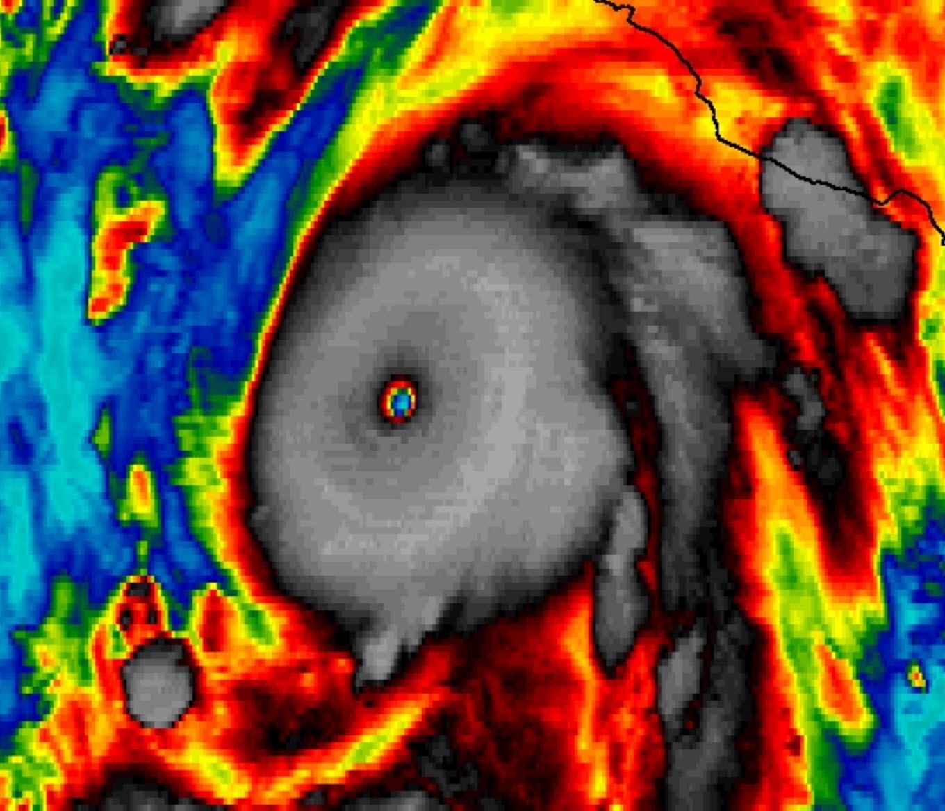
Patricia – A truly extraordinary meteorological phenomena – has become the strongest hurricane ever observed in the eastern Pacific or Atlantic oceans. Maximum sustained winds measured by a hurricane hunter aircraft are at 200 MPH – the strength of an EF5 tornado. The minimum central pressure was recorded at a record low 880 millibars. Not only is that the lowest ever measured in the eastern Pacific but it also eclipses the Atlantic record set by Wilma nearly 10 years ago to this date. The hurricane will make landfall later today as a catastrophic Category 5 hurricane in Mexico. Patricia’s moisture will move northeast and interact with a separate low pressure expected to bring rains to parts of Texas this weekend. The hurricane itself will not hit Texas – but the moisture from the system will create a flooding threat. We’ll talk more in depth about the Texas weather forecast in our usual Texas Weather Roundup later this morning.

HURRICANE PATRICIA ADVISORY NUMBER 14
NWS NATIONAL HURRICANE CENTER MIAMI FL EP202015
400 AM CDT FRI OCT 23 2015
…PATRICIA…
…THE STRONGEST EASTERN NORTH PACIFIC HURRICANE ON RECORD…
…POTENTIALLY CATASTROPHIC LANDFALL IN SOUTHWESTERN MEXICO LATER
TODAY…
SUMMARY OF 400 AM CDT…0900 UTC…INFORMATION
———————————————-
LOCATION…17.0N 105.5W
ABOUT 160 MI…255 KM SSW OF MANZANILLO MEXICO
ABOUT 235 MI…380 KM S OF CABO CORRIENTES MEXICO
MAXIMUM SUSTAINED WINDS…200 MPH…325 KM/H
PRESENT MOVEMENT…NNW OR 340 DEGREES AT 12 MPH…19 KM/H
MINIMUM CENTRAL PRESSURE…880 MB…25.99 INCHES
WATCHES AND WARNINGS
——————–
CHANGES WITH THIS ADVISORY:
None
SUMMARY OF WATCHES AND WARNINGS IN EFFECT:
A Hurricane Warning is in effect for…
* San Blas to Punta San Telmo
A Hurricane Watch is in effect for…
* East of Punta San Telmo to Lazaro Cardenas
A Tropical Storm Warning is in effect for…
* East of Punta San Telmo to Lazaro Cardenas
A Hurricane Warning means that hurricane conditions are expected
somewhere within the warning area, in this case within about 24
hours. Preparations to protect life and property should be rushed to
completion.
A Tropical Storm Warning means that tropical storm conditions are
expected somewhere within the warning area.
A Hurricane Watch means that hurricane conditions are possible
within the watch area.
For storm information specific to your area, please monitor
products issued by your national meteorological service.
DISCUSSION AND 48-HOUR OUTLOOK
——————————
At 400 AM CDT (0900 UTC), the eye of Hurricane Patricia was
located near latitude 17.0 North, longitude 105.5 West. Patricia
is moving toward the north-northwest near 10 mph (17 km/h). A turn
toward the north is expected later this morning, followed by a turn
toward the north-northeast this afternoon. On the forecast track,
the core of Patricia will make landfall in the hurricane warning
area this afternoon or evening.
Reports from an Air Force Hurricane Hunter aircraft indicate that
the maximum sustained winds have increased to near 200 mph (325
km/h) with higher gusts. Patricia is a category 5 hurricane on the
Saffir-Simpson Hurricane Wind Scale. Some fluctuations in intensity
are possible today, but Patricia is expected to remain an extremely
dangerous category 5 hurricane through landfall.
Hurricane force winds extend outward up to 30 miles (45 km) from the
center and tropical storm force winds extend outward up to 175 miles
(280 km).
The estimated minimum central pressure is 880 mb (25.99 inches).
HAZARDS AFFECTING LAND
———————-
WIND: Hurricane conditions are expected to first reach the
hurricane warning area this afternoon. Tropical storm conditions
are beginning to spread across portions of the warning area.
Preparations to protect life and property should be rushed to
completion. Hurricane conditions are possible in the hurricane
watch area later today.
RAINFALL: Patricia is expected to produce total rainfall
accumulations of 8 to 12 inches, with isolated maximum amounts of 20
inches, over the Mexican states of Nayarit, Jalisco, Colima,
MIchoacan and Guerrero through Saturday. These rains could produce
life-threatening flash floods and mud slides.
STORM SURGE: An extremely dangerous storm surge is expected to
produce significant coastal flooding near and to the right of where
the center makes landfall. Near the coast, the surge will be
accompanied by large and destructive waves.
SURF: Swells generated by Patricia are already affecting portions
of the southern coast of Mexico, and will spread northwestward
during the next day or so. These swells are likely to cause
life-threatening surf and rip current conditions. Please consult
products from your local weather office.


0 Comments