

Forecast precipitable water values by late Tuesday afternoon. The cool front is easily identifiable across South Texas.
A cool front is located along a line extending from Eagle Pass northeast to just north of San Antonio to near Brenham northeast to Conroe and Natchitoches, Louisiana. The front continues its southward trek and will push into South Texas and the remainder of Southeast Texas today. Moisture levels north of the front drastically decrease with a very dry airmass filtering in from the north. Dewpoint temperatures north of the front are in the 30s and 40s. South of the front tropical moisture is in place with dewpoints in the 70s.

Observed temperatures at 6 AM across Texas
The dry airmass in place north of the cool front along with clear skies have allowed temperatures to fall 30 to 40 degrees from their peaks Monday afternoon. A dry-airmass allows for fairly impressive temperature swings with warm weather during the day and cool weather overnight. These temperature swings will continue for a few days until we start to see moisture levels increase or other factors intervene like cloud cover.
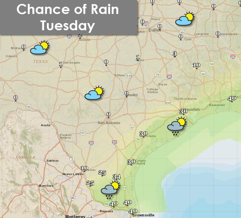
Chance of rain later this morning into the afternoon hours
As the cool front moves south and interacts with rich tropical moisture there will likely be isolated to scattered showers as the atmosphere destabilizes. The best rain chances (30 to 40 percent chance) will be along the Texas coast, Deep South Texas, and the Rio Grande Valley. Rain amounts will be light and only isolated thunderstorms are expected on-shore.

This afternoon’s high temperature forecast from the National Weather Service
Temperatures north of of the cool front won’t be that cool. Compared to Monday temperatures will be about ten degrees cooler but still above average for mid-October. Winds will be noticeably lighter today. Humidity values this afternoon will drop below 30 percent across most locations north of the cool front. Elevated wildfire danger is a concern. Folks across the RIo Grande Valley and Deep South Texas will be the warmest with mid 90s. Even north of the front folks in San Antonio over to College Station will still warm quickly today with high temperatures in the 93 to 95 degree range.
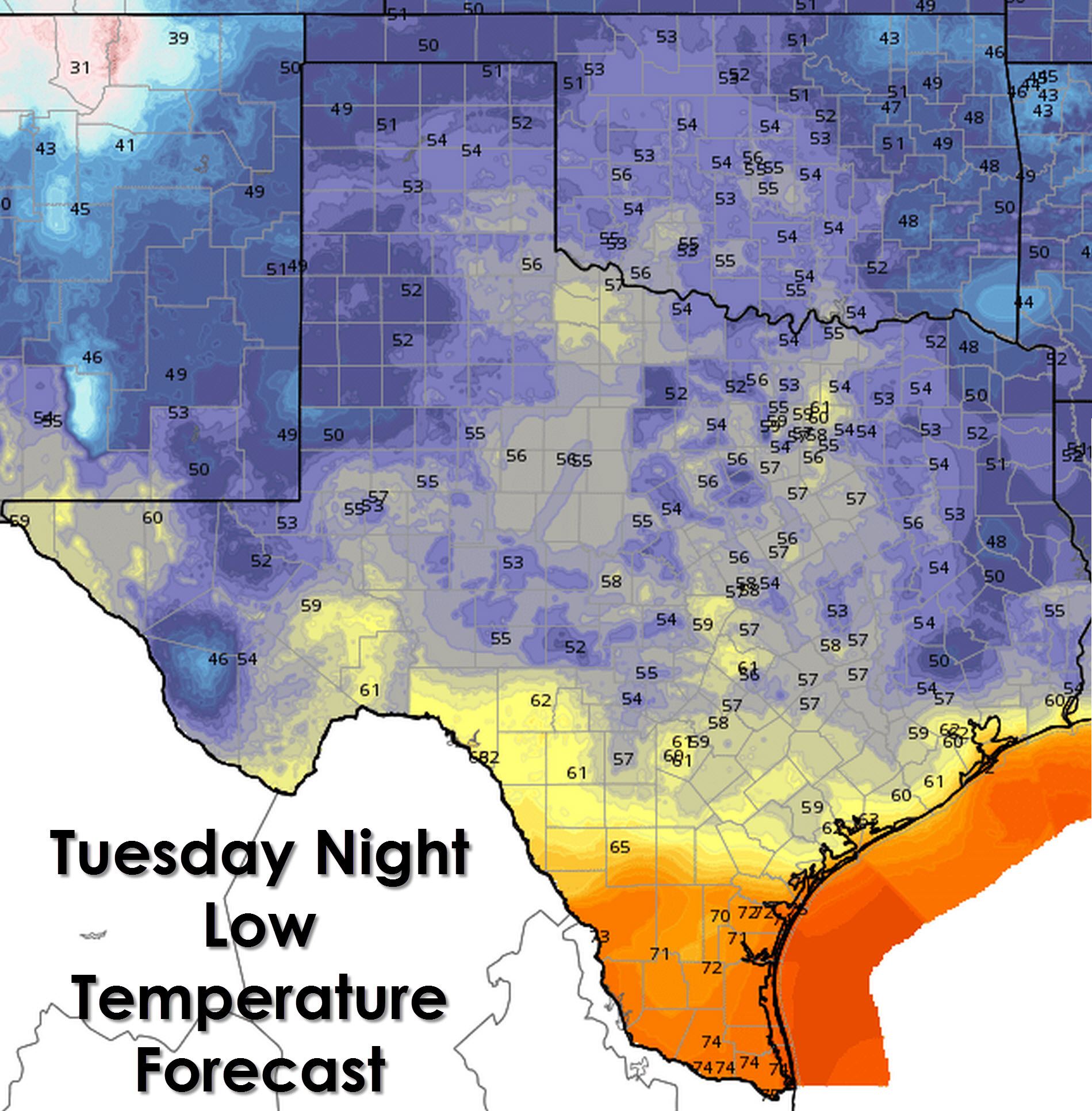
Tuesday Night’s Forecast Low Temperatures from the National Weather Service
The Rio Grande Valley will remain warm tonight with low temperatures in the 70s with tropical moisture remaining in place. The rest of Texas will be located in a dry airmass. Temperatures will drop off quickly after sunset. By Wednesday morning temperatures will bottom out 30 to 40 degrees below their peaks this afternoon with 40s and 50s in most spots. I suppose you could say both summer and fall weather fans will get their choice.
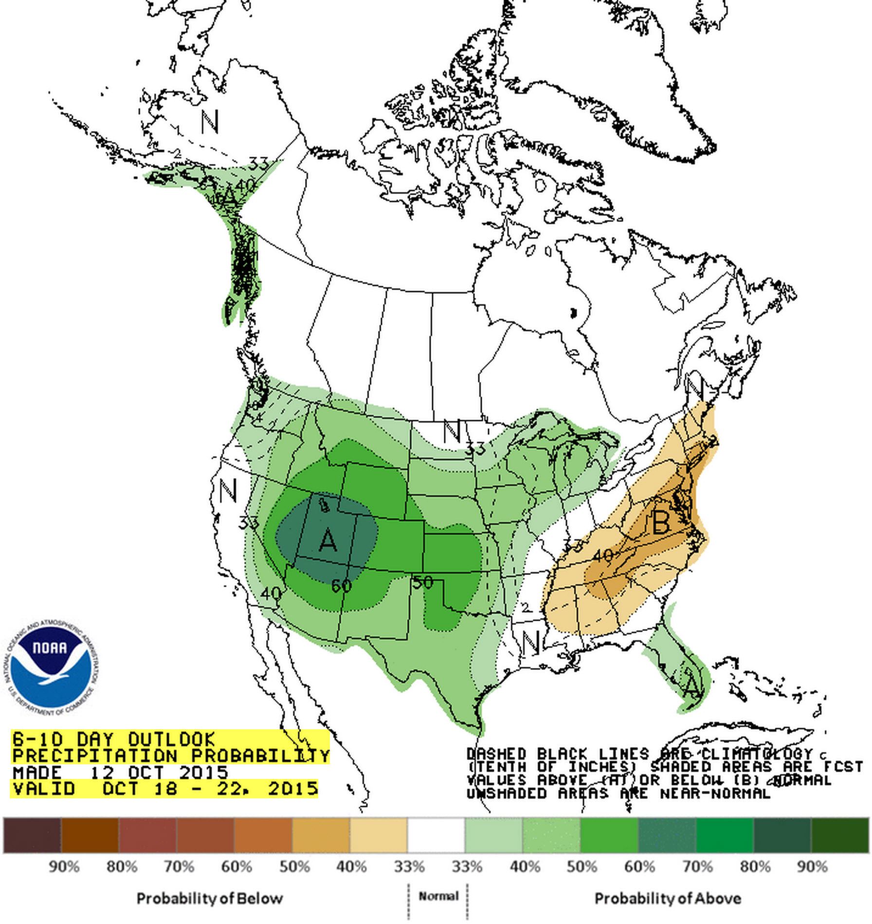
Precipitation outlook for October 18-22 from the Climate Prediction Center
Weather across Texas will generally remain inactive this week. There are a few light rain chances possible across the Texas Panhandle as a storm system skirts by later this week. Otherwise a southerly flow will start to gradually pump moisture back into the state with average to above-average temperatures continuing. Another cold front will move in towards the end of the week helping to drop temperatures across the northwest half of the state. The American and European weather models loosely agree that a pattern change could occur next week. At this time it doesn’t look like temperatures will take a big dive but rain chances are looking up. There remains plenty of uncertainty but its looking possible that our first good precipitation event of October could unfold next week. Assuming timing doesn’t change (which it likely will) it would start out on Monday/Tuesday in the Panhandle and western Texas before spreading east into much more of Texas by the middle part of next week. As always I caution you that plenty will change between now and a week from now.


0 Comments