
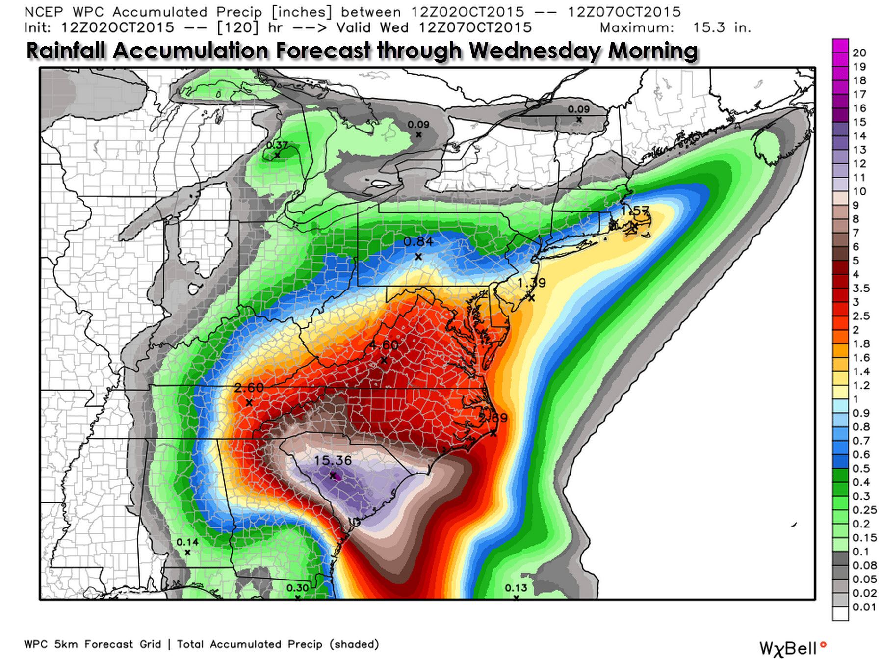
Hurricane Joaquin will pass several hundred miles east of the United States over the next few days as it moves north and eventually northeast. Even though the hurricane will pass well offshore the impacts will still be felt. A catastrophic flooding event is forecast across the Carolinas into parts of Georgia and Virginia. Some locations in the Carolinas could receive up to 15 inches of rain over the next few days. The hurricane itself will not be the cause of this rain as another low pressure area will be the actual system involved. Battering waves caused by Joaquin are and will continue to batter the eastern United States coastline. Beach erosion and coastal flooding is a good bet and is already occuring this morning in parts of the Mid-Atlantic.
NATIONAL WEATHER SERVICE CHARLESTON SC
408 AM EDT FRI OCT 2 2015
…HISTORIC RAINFALL AND LIFE-THREATENING FLASH FLOODING POSSIBLE
THROUGH SUNDAY…
.TROPICAL MOISTURE STREAMING NORTHWARD AHEAD OF HURRICANE JOAQUIN
COMBINED WITH A STRONG UPPER LEVEL LOW PRESSURE SYSTEM AND A
STALLED FRONT OFFSHORE WILL PRODUCE WIDESPREAD HEAVY RAINFALL
ACROSS SOUTHEAST SOUTH CAROLINA THROUGH THE WEEKEND. HISTORIC
RAINS AND LIFE THREATENING FLASH FLOODS ARE POSSIBLE.
…FLASH FLOOD WATCH REMAINS IN EFFECT THROUGH SUNDAY AFTERNOON…
THE FLASH FLOOD WATCH CONTINUES FOR
* A PORTION OF SOUTHEAST SOUTH CAROLINA…INCLUDING THE FOLLOWING
ALLENDALE…BEAUFORT…CHARLESTON…COASTAL …
COLLETON…COASTAL JASPER…DORCHESTER…HAMPTON…INLAND
BERKELEY…INLAND COLLETON…INLAND JASPER AND TIDAL BERKELEY.
THIS INCLUDES THE CHARLESTON METRO AREA.
* THROUGH SUNDAY AFTERNOON.
* WIDESPREAD HEAVY RAIN IS EXPECTED TO AFFECT MUCH OF SOUTHEAST
SOUTH CAROLINA INTO SUNDAY AFTERNOON AS TROPICAL MOISTURE
INTERACTS WITH A STALLED FRONT OFFSHORE OF THE SOUTHEAST COAST.
HEAVY RAIN COULD OCCUR AT ANY TIME TODAY…BUT WIDESPREAD HEAVY
RAINS ARE MORE LIKELY TONIGHT INTO SUNDAY AS LOW PRESSURE
APPROACHES THE COAST. RAIN AMOUNTS OF 9 TO 14 INCHES ARE LIKELY
THROUGH THE PERIOD WITH LOCALIZED AMOUNTS POSSIBLY EXCEEDING 15
INCHES. THIS HISTORIC RAINFALL COULD PRODUCE UNUSUAL AND LIFE-
THREATENING FLASH FLOODING ACROSS SOUTHEAST SOUTH CAROLINA.
ACROSS THE COASTAL COUNTIES…INCLUDING DOWNTOWN CHARLESTON…
THE RISK FOR DANGEROUS FLASH FLOODING WILL BE ESPECIALLY HIGH
AROUND TIMES OF HIGH TIDE.
* THIS HAS THE POTENTIAL TO BECOME A RECORD-SETTING RAIN EVENT
WITH LIFE-THREATENING FLASH FLOODING. DURING THE TIMES OF
HEAVIEST RAINFALL…ROAD CLOSURES COULD BECOME COMMON AND
MOTOR VEHICLE TRAVEL COULD BECOME IMPOSSIBLE. WHERE THE
HEAVIEST RAIN FALLS…STANDING WATER COULD REMAIN AND COULD
IMPEDE OR PREVENT TRAVEL FOR EXTENDED PERIODS OF TIME. IN SOME
AREAS…WATER COULD ENTER STRUCTURES.
Hurricane Joaquin remains an extremely dangerous hurricane in the Central Bahamas. With maximum sustained winds of 130 MPH the storm continues to be dangerous. Weather model guidance over the past twenty-four hours has come into better agreement regarding the path the hurricane will take. After Joaquin doodled in the Bahamas it missed its chance to move northwest towards the eastern United States. In all likelihood Joaquin will pass several hundred miles east of the United States as it moves north and eventually northeast.
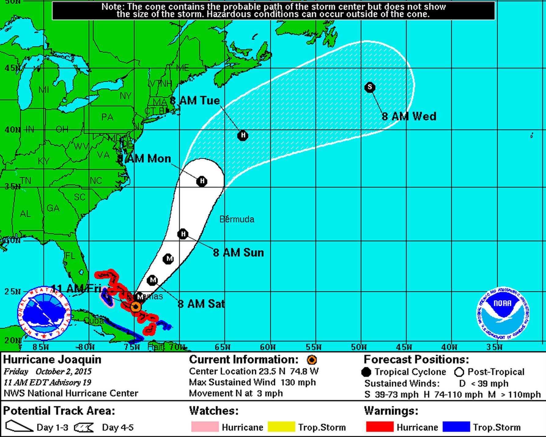
HURRICANE JOAQUIN ADVISORY NUMBER 19
NWS NATIONAL HURRICANE CENTER MIAMI FL AL112015
1100 AM EDT FRI OCT 02 2015
…EXTREMELY DANGEROUS JOAQUIN NOW MOVING NORTHWARD AS IT BATTERS
THE CENTRAL BAHAMAS…
…HURRICANE CONDITIONS TO CONTINUE OVER THE CENTRAL BAHAMAS
TODAY…
SUMMARY OF 1100 AM EDT…1500 UTC…INFORMATION
———————————————–
LOCATION…23.5N 74.8W
ABOUT 5 MI…10 KM S OF RUM CAY BAHAMAS
ABOUT 40 MI…65 KM SSW OF SAN SALVADOR BAHAMAS
MAXIMUM SUSTAINED WINDS…130 MPH…215 KM/H
PRESENT MOVEMENT…N OR 0 DEGREES AT 3 MPH…6 KM/H
MINIMUM CENTRAL PRESSURE…939 MB…27.73 INCHES
WATCHES AND WARNINGS
——————–
CHANGES WITH THIS ADVISORY:
None.
SUMMARY OF WATCHES AND WARNINGS IN EFFECT:
A Hurricane Warning is in effect for…
* Central Bahamas
* Northwestern Bahamas including the Abacos, Berry Islands,
Eleuthera, Grand Bahama Island, and New Providence
* The Acklins, Crooked Island, and Mayaguana in the southeastern
Bahamas
A Hurricane Watch is in effect for…
* Bimini
* Andros Island
A Tropical Storm Warning is in effect for…
* Remainder of the southeastern Bahamas including the Turks and
Caicos Islands
* Andros Island
* Cuban provinces of Camaguey, Las Tunas, Holguin, and Guantanamo
A Hurricane Warning means that hurricane conditions are expected
somewhere within the warning area.
A Hurricane Watch means that hurricane conditions are possible
within the watch area.
A Tropical Storm Warning means that tropical storm conditions are
expected somewhere within the warning area.
Interests in Bermuda should monitor the progress of Joaquin. A
Tropical Storm or Hurricane Watch may be required later today.
For storm information specific to your area, please monitor
products issued by your national meteorological service.
DISCUSSION AND 48-HOUR OUTLOOK
——————————
At 1100 AM EDT (1500 UTC), the center of Hurricane Joaquin was
located near latitude 23.5 North, longitude 74.8 West. Joaquin is
moving toward the north near 3 mph (6 km/h), and a northward motion
at a faster forward speed is expected today. A turn toward the
northeast is expected tonight with an additional increase in
forward speed. On the forecast track, the core of the strongest
winds of Joaquin will continue moving over portions of the central
and northwestern Bahamas today. Joaquin will begin to move away from
the Bahamas tonight and Saturday.
Reports from an Air Force Reserve Hurricane Hunter aircraft
indicate that maximum sustained winds remain near 130 mph (215 km/h)
with higher gusts. Joaquin is a category 4 hurricane on the
Saffir-Simpson Hurricane Wind Scale. Some fluctuations in intensity
are possible during the next 24 hours. Slow weakening is expected to
begin on Saturday.
Hurricane force winds extend outward up to 50 miles (85 km) from the
center and tropical storm force winds extend outward up to 205 miles
(335 km).
The minimum central pressure from Hurricane Hunter aircraft data is
939 mb (27.73 inches).
HAZARDS AFFECTING LAND
———————-
WIND: Hurricane conditions are expected to continue across portions
of the central and southeastern Bahamas through today. Hurricane
and tropical storm conditions are expected over portions of the
northwestern Bahamas today. Tropical storm conditions will affect
other portions of the southeastern Bahamas and the Turks and Caicos
Islands today. Tropical storm conditions are expected over portions
of eastern Cuba through this morning.
STORM SURGE: A very dangerous and life-threatening storm surge will
raise water levels by as much as 6 to 12 feet above normal tide
levels in the central Bahamas in areas of onshore flow. A storm
surge of 2 to 4 feet above normal tide levels is expected in the
remainder of the Bahamas within the hurricane warning area. Near
the coast, the surge will be accompanied by large and dangerous
waves.
RAINFALL: Joaquin is expected to produce total rain accumulations
of 12 to 18 inches over the central Bahamas with isolated maximum
amounts of 25 inches. Rainfall amounts of 5 to 10 inches are
expected over the southeastern Bahamas, with 2 to 4 inches over the
northwestern Bahamas, eastern Cuba, Haiti, the Dominican Republic,
and the Turks and Caicos Islands. This rainfall could result in
life-threatening flash floods.
SURF: Swells generated by Joaquin will affect portions of the
Bahamas during the next few days. Swells have begun to affect
portions of the southeastern coast of the United States and will
spread northward along the east coast of the United States through
the weekend. These swells are likely to cause life-threatening surf
and rip current conditions. Even though Joaquin is expected to
pass well east of the coast of the United States, a prolonged
period of elevated water levels and large waves will affect the
mid-Atlantic region, causing significant beach and dune erosion with
moderate coastal flooding likely. Please consult products from your
local weather office.


0 Comments