
Major Hurricane Rita made landfall just before 2 AM on September 24, 2005 on the Texas/Louisiana border near Sabine Pass. Rita came at a time where the impacts from Katrina were still fresh. New Orleans was slowly being drained of flood waters and evacuees were still displaced all over the United States.
What would become Rita emerged off the west coast of Africa on September 7, 2005. It wasn’t until September 17 that the tropical wave became organized enough to be designated a tropical depression near Grand Turk. Three days later Rita became a hurricane about 100 miles south of Key West, Florida on September 20. With Rita now in the southeastern Gulf of Mexico a rapid strengthening episode insued. Hurricane Rita reached Category 3 status early in the morning of September 21. Rapid strengthening continued and Rita reached peak intensity of 180 MPH during the evening hours on September 21. It was during this timeframe that Rita became the fourth strongest hurricane ever recorded in the Atlantic basin.

ANIMATION: Hurricane Rita near peak intensity on September 22
After exiting the loop current and moving into a slightly less favorable environment Rita began to slowly weaken on September 23. This slow weakening trend continued through landfall. Rita made landfall near Sabine Pass, Texas at 2:40 AM on September 24, 2005 with maximum sustained winds at 115 MPH with higher wind gusts.
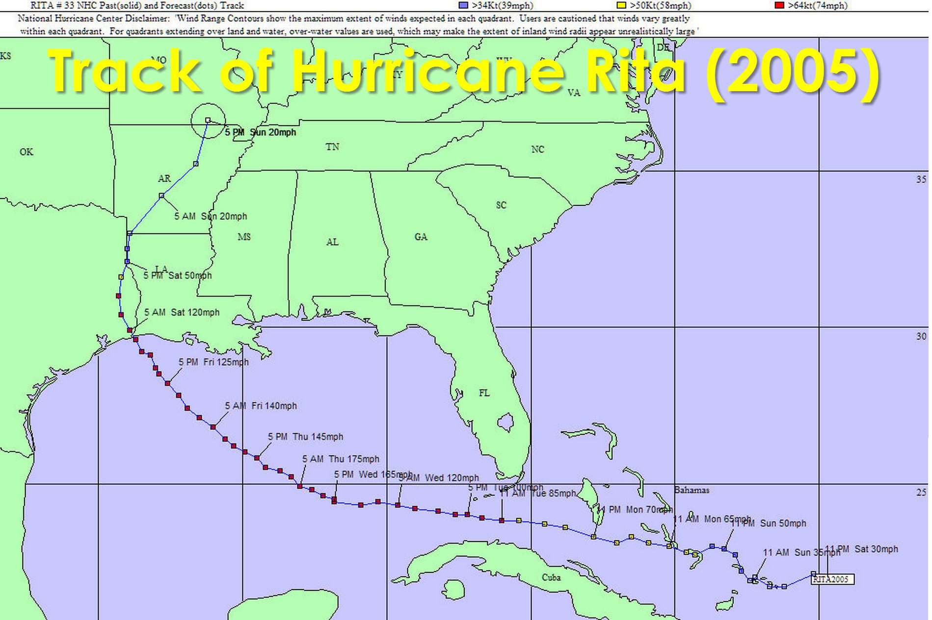
Because Rita made landfall on the Texas/Louisiana border the most severe impacts were felt in Southwest Louisiana. The less intense western semicircle of Rita over Texas resulted in an offshore flow and a storm surge of 3 to 5 feet compared to 7 feet in southwest Louisiana. One consequence of the north winds was some surge issues on the northern shore of Galveston Bay and a surge on Lake Livingston which is located 60 miles north of Houston. Much of Southeast Texas did experience sustained tropical storm force winds. Flooding rains did occur in East Texas with 5 to 10 inches of rain. Luckily for us the most severe impacts from Rita stayed east of Texas. In terms of tornadoes produced by a tropical cyclone Rita was very significant having produced 90+ tornadoes – many of which occurred within a 48 hour period after landfall.

Hurricane Rita Evacuation from NWS Houston
Some readers here will remember the mass evacuation of the Houston metropolitan area. Estimates place the number evacuated from Texas alone exceed two million and obviously many remember the insane traffic jams that resulted. There were four direct fatalities caused by Rita with many more killed indirectly. Some may question the need for such a mass-evacuation when Rita ended up mainly missing Houston to the east. However had the storm moved just 100 miles further west the impacts to Southeast Texas would have been disastrous. The forecasting of hurricanes is still a relatively new science – as is meteorology – having just started a bit over a century ago. Uncertainty and variability will always be a part of the science. Three years later Hurricane Ike made landfall near Galveston, Texas with a catastrophic storm surge and widespread wind damage across Southeast Texas.
For more information and facts on Hurricane Rita we reccomend the following links.
NWS Houston event page on Hurricane Rita
Vast resource & information page on Rita from NWS Lake Charles


0 Comments