
At 4:22pm this afternoon, automated reporting sensors at Dallas Love Field reported a wind gust of 59 knots (~67mph) from the northeast. A strong thunderstorm had developed over Dallas at around 4pm, and while it was not strong enough to warrant a Severe Thunderstorm Warning, a Special Weather Statement had been issued by the NWS office in Ft. Worth at 4:06pm advising that winds in excess of 40mph and dime size hail were possible with this storm…with more strong winds expected as it weakened. After the initial report of the downburst at Dallas Love Field, reports of wind damage in areas near the airport began to filter in…mainly tree branches, some 5 to 12+ inches in diameter, snapped and broken off. So, what happened and what caused this sudden and damaging 68mph wind gust?
The answer is Downburst Winds…sometimes called Microbursts or Macrobursts depending upon the size of the area impacted. Downburst winds are fairly common with pop-up thunderstorms like the ones that erupted over Dallas and surrounding communities this afternoon. The potential for these to occur was in the morning forecast with a weak frontal/wind shift boundary stretched across the Dallas/Ft. Worth metroplex, and a weak upper level disturbance forecasted to arrive by the afternoon.
MODEL GUIDANCE SUGGESTS UP TO 1000 J/KG OF CAPE (potential energy in the atmosphere) MAY BE AVAILABLE FOR STORMS ALONG THE BOUNDARY…AND THIS COMBINATION OF CAPE AND SHEAR STRONGLY SUGGESTS ANY STORMS THAT DEVELOP WILL BE SINGLE CELL OR AIRMASS IN STRUCTURE. THE SEVERE WEATHER THREAT IS EXPECTED TO REMAIN VERY LOW TODAY AS A RESULT…WITH CLOUD TO GROUND LIGHTNING AND LOCALLY GUSTY DOWNBURST WINDS THE ONLY EXPECTED HAZARDS.
Several combinations of factors can create a storm capable of producing downburst winds. The first two, eluded to in the forecast is adequate atmospheric instability and a boundary. A source of lift is needed and that came in the form of a wind shift/frontal boundary and additional forcing from the upper level disturbance. A dry layer of air at the surface and at the mid to upper levels of the atmosphere is also a factor. Why is dry air a factor? Because it cools faster than moist/humid air. As we reached peak heating, a cumulus field developed over the area, and eventually one of the cells right over Dallas County quickly erupted, became strong and produced quite a bit of rain. That rain cooled the surface layer. The dry air in the mid-upper levels became entrained in the updraft which had become quite water loaded from its precipitation process. This cools the thunderstorm’s updraft. When that happens, negative buoyancy ensues and what was once being held up by the force of the updraft comes crashing back down to the surface. That is your downburst in a nutshell. Once that hits the earth’s surface, it actually accelerates outward and you get straight line winds and sometimes quite a bit of damage.
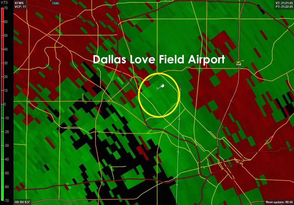
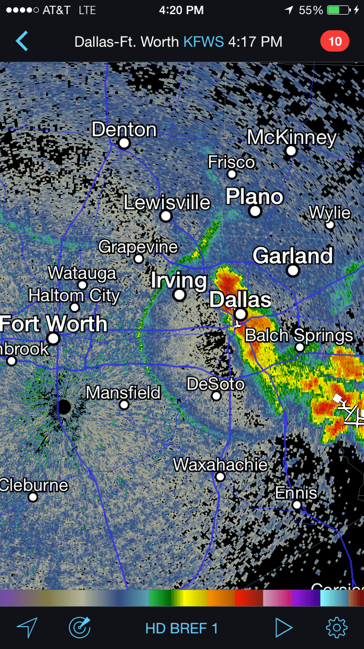
Here are a few radar graphics this afternoon at the time the time the downburst was reported at Dallas Love Field. The first is a radar graphic in velocity mode which offers a measure of wind speed and direction. Green indicates winds moving towards the radar (inbound winds), red indicates winds moving away from the radar (outbound winds). The “brightness” of the two colors can be used to determine potential wind speeds based on the legend on the left side of the image. You see radar images in velocity mode used to pinpoint the location of tornadic winds quite a bit, so a lot of folks are probably fairly familiar with this. See anything especially menacing over Dallas Love Field? No? Neither did the local NWS office. With the microburst being confined to such a small area, and just a general inability for the radar beam to measure the inbound winds effectively in this instance, there was no way to know about this microburst until after it was picked up by the airport’s sensors. The second graphic is in base reflectivity mode from my Radarscope app taken a minute or two before the microburst was reported. You can clearly see an outflow boundary being generated by the rain cooled air flowing from the storm, but again, nothing that would clue you in that a microburst was about to occur. So, today was an interesting study on how quickly these can develop, and how there’s sometimes really no way to issue a warning for them in an adequate amount of time.


0 Comments