
Good morning and welcome to the Texas Weather Roundup! These daily forecasts discuss the upcoming weather along with any hazardous weather potential. We post these daily every morning. It goes without saying we’re focused on the potential for a tropical storm to bring significant impacts to Texas on Tuesday and Wednesday. Even if the system does not become a tropical storm we’re going to have some big problems. Let’s talk about it!
First off we will have more popup storms this afternoon. Coverage may be a bit higher thanks to the tropical moisture flowing into the state from the Gulf of Mexico. A few storms may become strong with gusty downburst winds, frequent cloud to ground lightning, and locally heavy rain. Nothing unusual for a humid summer afternoon. The real problems begin on Tuesday.

Even though we’re within 36-48 hours of the system arriving in Texas there remains significant uncertainty on the system’s track. Overnight we have seen a slight westward shift in model guidance. This westward shift (should it occur) would result in the very heavy rain to fall just east of Interstate 35 into Northeast, East, and Southeast Texas. We expect landfall at some point on Tuesday between Corpus Christi and Galveston (probably somewhere in the middle of those two points). Like I said there remains significant uncertainty on the eventual track of the storm. Unlike a hurricane or even a strong tropical storm we continue to have a large, but disorganized area of low pressure in the southwest Gulf of Mexico this morning. Because of the disorganization it actually makes forecasting the track more difficult because once the low tightens up it could be anywhere within a 50-75 mile zone. If it forms 50 miles west of the above track map well there you go having to shift everything west 50 miles. Likewise it would be the same if everything shifted east.
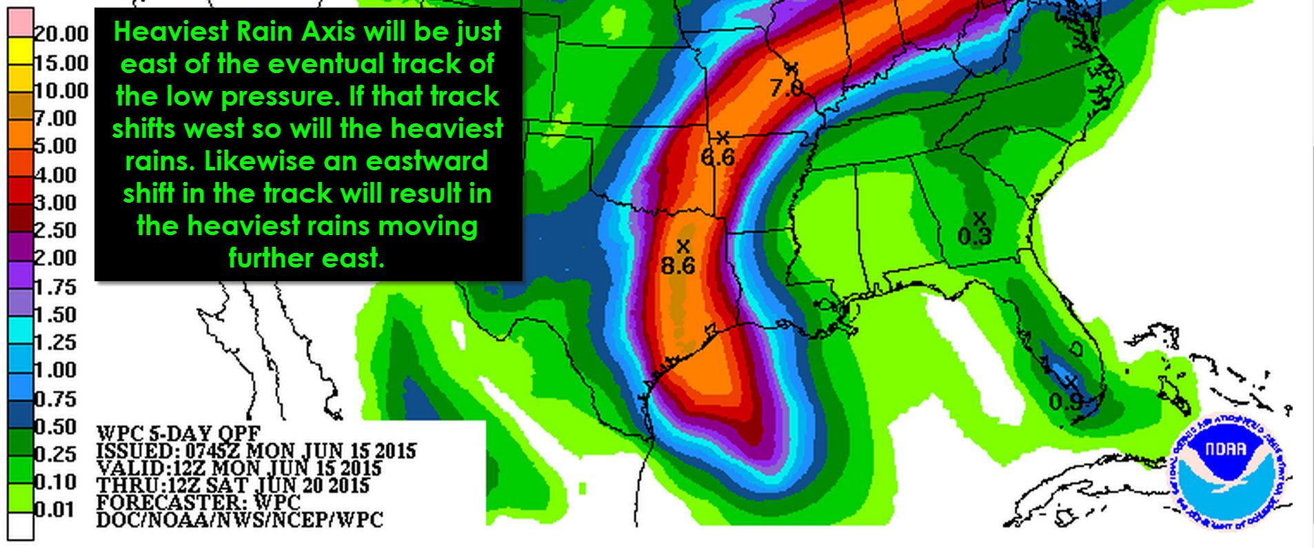
Fortunately if this system is able to develop tropical characteristics it will likely remain a weak/low-end tropical storm with 40-45 MPH winds. Storm surge and wind damage potential would remain quite limited. Regardless of this system becoming a tropical storm or not we’re going to have to deal with the rains. The heaviest rain will fall just east of the center’s track as it moves inland and north into Oklahoma. Many rivers and lakes remain fairly full after the May rains. Widespread 4 to 9 inches of rain will be possible just east of the center’s track with isolated rain totals over 12 inches possible. Dangerous flooding is expected where those rains fall. Rivers, streams, and creeks will all likely rapidly rise back into flood stage with the potential for major flooding even well after the rains stop. Where this ‘dangerous flooding’ zone sets up will depend on the storm’s track. I know I sound like a broken record but its true. If we see a continued westward shift in the storm’s track the Interstate 35 corridor from Oklahoma City south through the D/FW Metroplex into Austin and perhaps even San Antonio could end up under the bullseye of the heaviest rains. There will be a tight gradient of rain accumulations along and west of the storm where totals will drastic diminish.
Isolated tornadoes will be possible beginning early Tuesday along the Texas coast east of where the storm will make landfall. The threat for isolated tornadoes will continue east of the storm’s center as it moves north through Texas. In all likelihood any tornado that develops will be weak, short-lived, and completely rain-wrapped.
The hurricane hunters are en-route to Invest 91L to investigate it this morning. Should they find a defined low level circulation we’ll likely see the National Hurricane Center begin advisories on Tropical Storm Bill. Crews will continue flying missions into the system most of today and tonight keeping a close eye on it. I want to emphasise once again that even if this system does not become a tropical depression/tropical storm we’ll have significant rain and flooding impacts in Texas. It’s a moot point regardless.


0 Comments