
Ongoing strong storms heading east/northeast across parts of the western hill country and south Texas will have the potential for damaging winds and a few isolated tornadoes the morning and into the afternoon hours. One (radar indicated) tornado warned storm is currently affecting areas northwest of Corpus Christi near San Patricio. Others popping up here and there across the area within the Tornado Watch box is not out of the question through the remainder of this morning and into the afternoon hours. Additional moisture continues to stream north over the region this morning as a warm front begins to move north. This will work to increase overall instability and enhance storm development throughout the afternoon. Very heavy downpours are also likely with Flash Flooding an additional concern. Have a way to receive weather warnings either by smartphone app or NOAA Weather Radio.
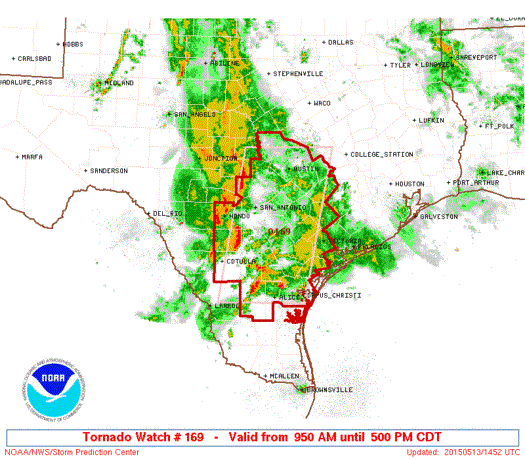
950 AM CDT WED MAY 13 2015

   THE NWS STORM PREDICTION CENTER HAS ISSUED A

   * TORNADO WATCH FOR PORTIONS OF
     SOUTH TEXAS
     COASTAL WATERS

   * EFFECTIVE THIS WEDNESDAY MORNING AND AFTERNOON FROM 950 AM
     UNTIL 500 PM CDT.

   * PRIMARY THREATS INCLUDE...
     A FEW TORNADOES POSSIBLE
     ISOLATED DAMAGING WIND GUSTS TO 70 MPH POSSIBLE
     ISOLATED LARGE HAIL EVENTS TO 1 INCH IN DIAMETER POSSIBLE

   SUMMARY...WIDELY SCATTERED THUNDERSTORMS WITH A RISK FOR
   TORNADOES...AND AN EASTWARD-MOVING LINE OF STORMS WEST WITH A RISK
   OF LOCALLY DAMAGING WIND AND BRIEF TORNADOES...WILL AFFECT PARTS OF
   SOUTH TEXAS THROUGH THE AFTERNOON.

   THE TORNADO WATCH AREA IS APPROXIMATELY ALONG AND 60 STATUTE
   MILES EAST AND WEST OF A LINE FROM 20 MILES WEST SOUTHWEST OF
   ALICE TEXAS TO 30 MILES NORTH OF AUSTIN TEXAS.


0 Comments