
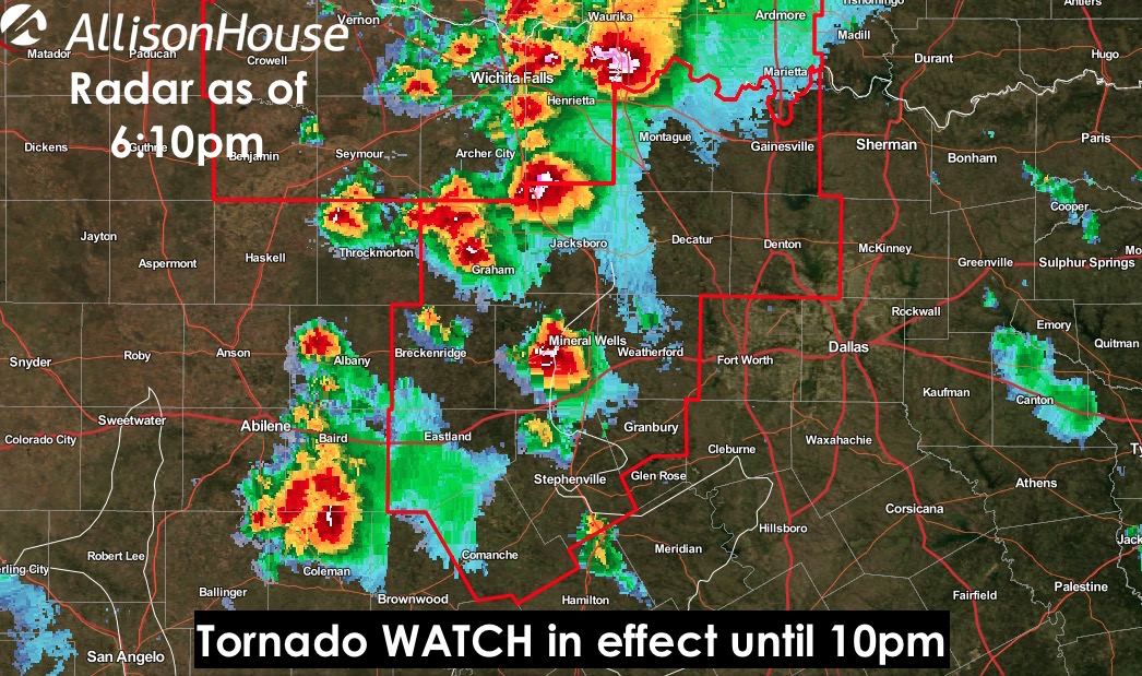
The previous tornado watch for portions of northwest Texas has been extended to include parts of north central Texas including the following counties: Cooke, Comanche, Denton, Eastland, Erath, Hood, Jack, Montague, Palo Pinto, Parker, Stephens, Wise and Young. Thunderstorms are increasing in coverage across parts of north central Texas tracking northeast through the area at around 30mph. Large hail up to 2 inches in diameter and damaging winds are the main threats; however, an couple of additional tornadoes on top of the (radar indicated tornado) currently just southwest of Mineral Wells is not out of the question. Folks within the WATCH area will need to pay attention to the weather this evening and have a way to receive weather warnings should any be issued for your particular location.
555 PM CDT TUE MAY 19 2015

   THE NWS STORM PREDICTION CENTER HAS ISSUED A

   * TORNADO WATCH FOR PORTIONS OF
     NORTH CENTRAL TEXAS

   * EFFECTIVE THIS TUESDAY AFTERNOON AND EVENING FROM 555 PM UNTIL
     1000 PM CDT.

   * PRIMARY THREATS INCLUDE...
     A COUPLE TORNADOES POSSIBLE
     SCATTERED LARGE HAIL AND ISOLATED VERY LARGE HAIL EVENTS TO 2
       INCHES IN DIAMETER POSSIBLE
     ISOLATED DAMAGING WIND GUSTS TO 70 MPH POSSIBLE

   SUMMARY...THUNDERSTORMS ARE INCREASING OVER NORTH CENTRAL TX BETWEEN
   ABILENE AND WICHITA FALLS. THESE STORMS WILL SPREAD EASTWARD ACROSS
   THE WATCH AREA DURING THE EARLY EVENING HOURS...POSING A THREAT OF
   LARGE HAIL AND ISOLATED TORNADOES.

   THE TORNADO WATCH AREA IS APPROXIMATELY ALONG AND 45 STATUTE
   MILES NORTH AND SOUTH OF A LINE FROM 60 MILES WEST SOUTHWEST OF
   MINERAL WELLS TEXAS TO 50 MILES NORTH NORTHEAST OF FORT WORTH
   TEXAS.


0 Comments