
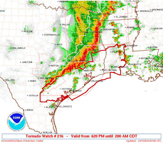
The squall line of severe storms continues to move into and out of far east/northeast Texas this evening with the back edge of it now crossing the border into Louisiana. Across south central and southeast Texas, we have several more hours of severe weather to endure before the line moves out between 2 and 3am tomorrow morning. Houston and Beaumont areas…you’ll be seeing this line move through in about and hour or two. Areas north and northwest of Houston…Cleveland, The Woodlands, Tomball, Sealy, Columbus and Halletsville…you’ll be impacted shortly. The main threats will continue to be strong winds in excess of 60mph and tornadoes along the leading edge of the squall line as it continues to push south and east across the area. Flooding will also be a concern as these cells train over the same area for a good amount of time before moving south. The line itself if moving south/southeast at around 30mph, but the storms within the line are moving northeast at around 50mph. This makes it an especially dangerous situation for tornadic development as they can quickly spin up before a warning has a chance to be issued. Everyone in the path of this squall line needs to take immediate action if a warning is issued for your area. Have a way to receive weather warnings…either by NOAA weather radio or smartphone weather app. Also note that many of these smartphone alert apps will not work if the phone is on Mute or Silence, so keep that in mind as you head to bed tonight if you’re still in the path of these storms.


0 Comments