
Good evening,
I hope you’ve been enjoying the wonderful weather we’ve experienced today. It isn’t often we end up with high temperatures in the 60s and 70s with relatively low humidity values in late April. That all is going to change tonight into tomorrow as we see moist air stream northward from the Gulf of Mexico. This is the first step in priming up the atmosphere to support thunderstorm chances this week. Right now it looks like parts of Texas will have the chance for severe thunderstorms on Tuesday, Wednesday, Thursday, and Friday. Each day will have unique aspects to it. Considering we’re still outside 48 hours for most of the upcoming event this post is mainly more of a heads up to introduce the threat for an active period of weather.
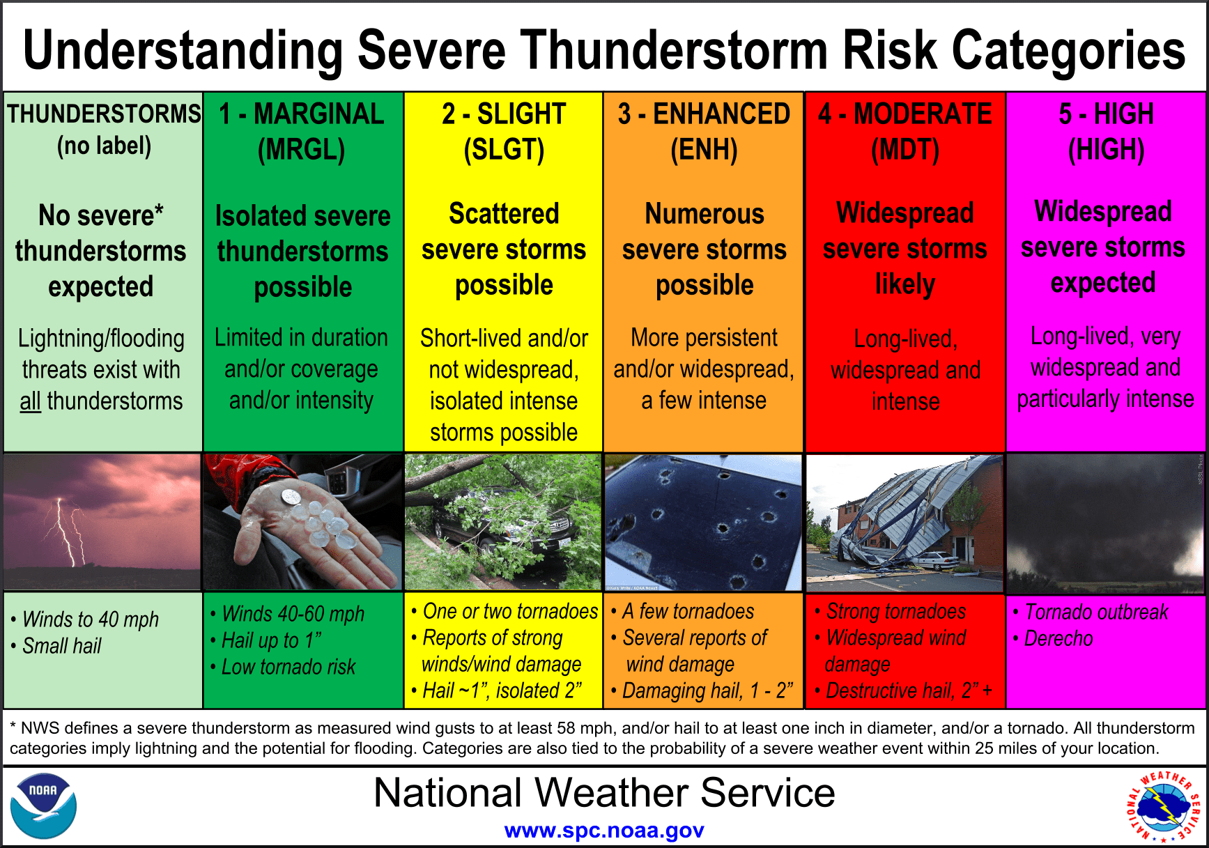
Risk definitions for severe weather outlook
We’ll be looking a lot at severe weather outlooks this week so lets first review the definitions. The Storm Prediction Center uses five risk categories ranging from marginal (1) which is more common increasing in severity and rarity up to a high risk (5) which is only used one to three times a year nationwide. The number of severe thunderstorms, their expected intensity, longevity, and forecast confidence all goes into making a severe weather outlook.
Tuesday, April 21
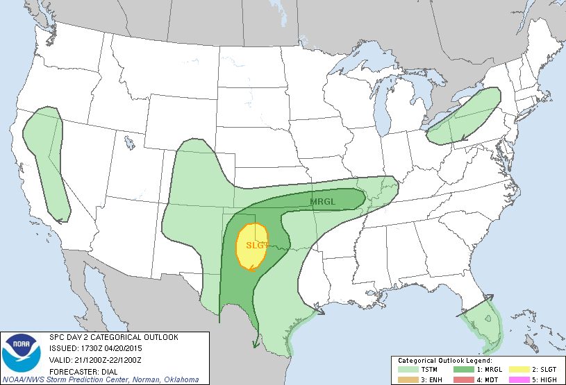
The Storm Prediction Center has issued a Slight Risk (2) for West-Central Texas, the southeastern Texas Panhandle, and Southwest Oklahoma. A marginal risk (1) includes most of the Texas Panhandle, Northwest Texas, Permian Basin, parts of the Big Country, and Southwest Texas. Thunderstorms are possible tonight in the Texas Panhandle but these are not going to be severe. By tomorrow we should have dewpoint values of at least 50 degrees in the eastern Texas Panhandle with 60 degree dew points in parts of the Big Country by 6 PM Tuesday. These moisture values are not ideal for significant severe weather but will support the threat for a few severe thunderstorms. Wind shear and atmospheric instablity will support the threat for organized thunderstorms from about 5 PM Tuesday through 10 PM. Thunderstorm coverage is not expected to be widespread due to a strong cap and limited moisture quality. The strongest storms will probably be supercellular with the threat for large hail and localized damaging wind gusts. The limited moisture along with weak low level wind shear will keep the tornado threat non-zero tomorrow.
Wednesday, April 22
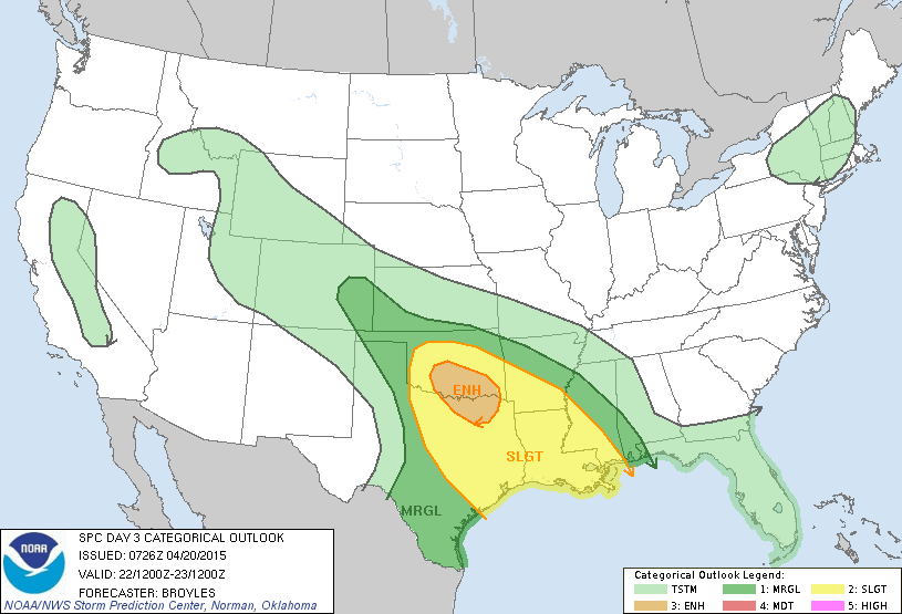
Wednesday has the potential to feature more widespread severe weather across the state as an upper level storm system helps bring more lift. In addition we’ll have dewpoint values of 65+ degrees in place which will support an even more unstable atmosphere. Wind shear values will also be supportive of organized thunderstorms. The Storm Prediction Center has already issued an enhanced risk (3) of severe weather for portions of North and Northeast Texas into Central Oklahoma. A slight risk (2) includes the Concho Valley, North Texas, Central Texas, East Texas, and Southeast Texas. A marginal risk (1) runs from the Rio Grande Valley northward into the eastern Texas Panhandle. Being 3 days out there are several uncertainties included in the forecast. Some weather models indicate a cluster of severe thunderstorms will develop by mid-afternoon in Northwest Texas and Southwest Oklahoma and spread southeast into North Texas by late afternoon/early evening Wednesday. This cluster of storms would be capable of producing large hail up to the size of hen eggs, destructive wind gusts up to 75 MPH, and brief tornadoes. Essentially the threats would be similar to those experienced with the cluster of severe storms that impacted North and Northeast Texas last Thursday. Other models indicate the potential for more discrete supercellular thunderstorms by mid-afternoon which would be capable of producing baseball size hail, damaging wind gusts up to 70 MPH, and the possibility of tornadoes. In reality we may end up seeing a mixed convective mode with supercells and that cluster of thunderstorms. Either way an enhanced severe weather threat is expected on Wednesday and will be the first of potentially three days of enhanced severe weather potential.
Thursday, April 23
The Storm Prediction Center has highlighted North Texas, Northeast Texas, East Texas, Southeast Texas, South Texas, and Central Texas on Thursday for the potential of an en enhanced severe weather risk. Thunderstorms on Wednesday will play a role in where we end up seeing the most significant risk of severe weather on Thursday. Once again all modes of severe weather will be possible Thursday afternoon into Thursday evening with hail up to the size of baseballs, destructive wind gusts up to 75 MPH, and tornadoes. Specific hazard-related risks and the overall forecast will continue to be refined as we get closer to Thursday.
Friday, April 24
While this day is the farthest out it does have the potential to be a significant severe weather outbreak from Kansas southward into Oklahoma and Texas. Uncertainty remains high regarding the overall setup on Friday but it is an event with the potential of high-end severe weather. This could be the day where we see the highest tornado risk but there are a lot of questions and the answers could drastically change the forecast. I urge you to check back for forecast updates this week.
In summary we’re in late April and having the threat for severe weather is nothing new this time of year. There’s no reason to get anxious or freak out. What I advise you do before severe weather time is practice your safety plan with your family. Make sure you know where to go or what to do if you come under the gun. We’ll be sharing several articles this week on how you can prepare for severe weather and make your own safety plan.


0 Comments