
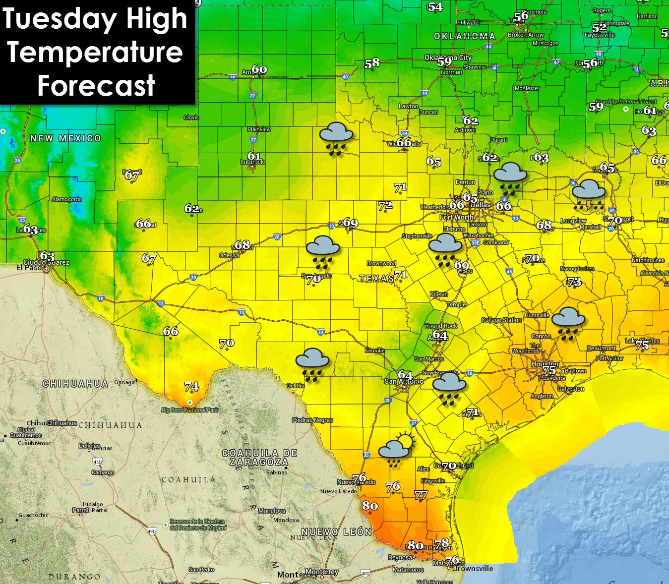
Today will end up being the warmest day most of Texas has seen in about two weeks. Enjoy it because we’ll be on the receiving end of another strong cold front late tonight into Wednesday. Widespread fog will continue this morning across most of Texas before letting up a bit as temperatures start climbing towards noon. Fog is expected again tonight. Areas of showers and possibly even a thunderstorm will be possible this afternoon across North and Northeast Texas. Rain chances will increase tonight from the Hill Country and Big Country eastward as upper level lift increases. Temperatures will be well above freezing today so winter weather is not a concern today. That won’t be true for Wednesday.
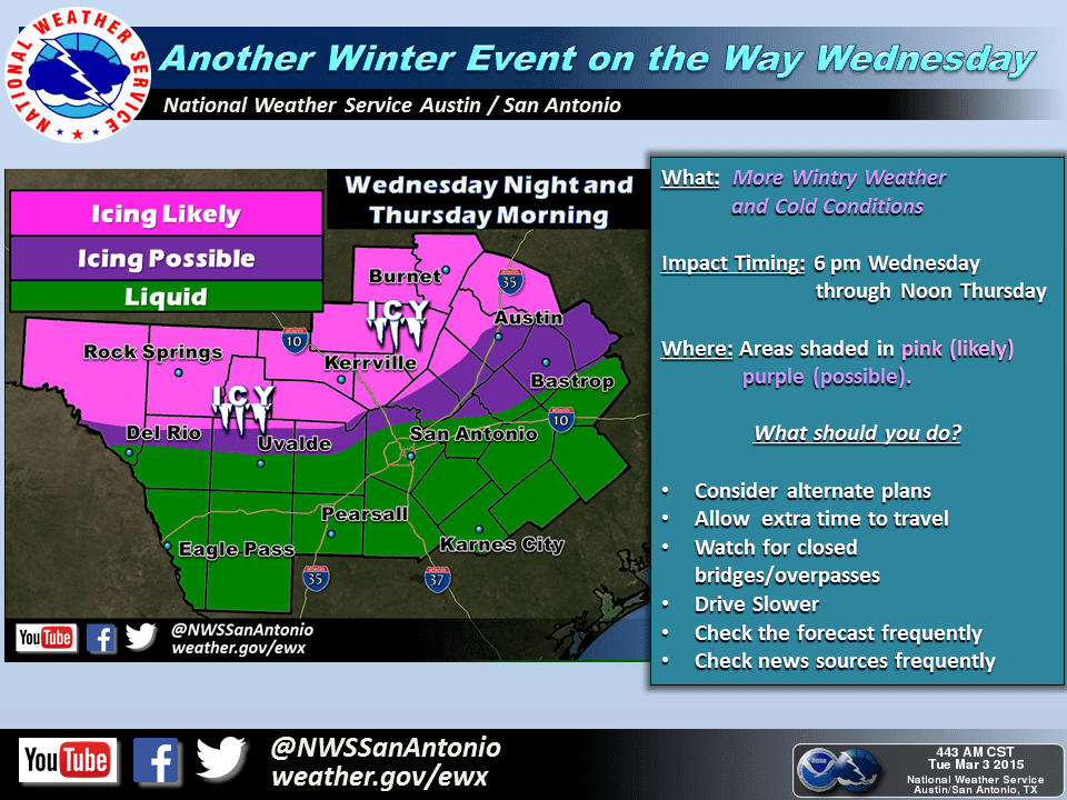
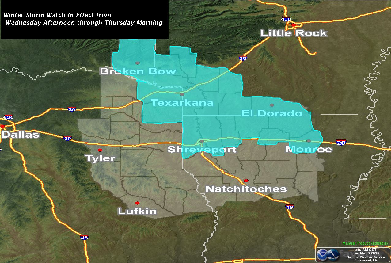
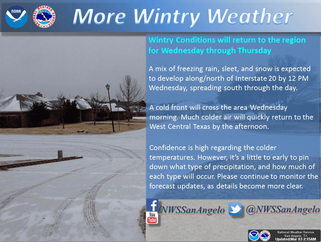
The forecast for Wednesday’s winter weather continues to remain uncertain due to several factors. What we do expect is the potential for light freezing rain and sleet during the afternoon and evening hours on Wednesday. While accumulations do not appear to be significant or anywhere near the levels we saw last week travel issues are a possibility. Right now travel issues appear possible from Northwest Texas and the Big Country into North, Northeast, and possibly Central Texas into the Brazos Valley. A Winter Storm Watch has been issued for extreme Northeast Texas including Texarkana where the most significant winter weather accumulations will be possible. The heaviest precipitation looks to be across Oklahoma into Arkansas while we in Texas will be on the edge of the system. If the storm track shifts south than we could end up with a more substantial winter weather event. Another factor that could make/break any sort of winter weather event will be how quickly temperatures cool off. If we end up hitting freezing more quickly than more precipitation will fall frozen. Some models suggest that could happen which would result in increased sleet/freezing rain accumulations across North, Northeast, East, Central Texas into the Brazos Valley. Hopefully we’ll get a better idea of whats to come with the 12Z model guidance we receive later this morning. Winter Weather Advisories will likely be issued with the afternoon forecast packages from the National Weather Service.

…WINTER WEATHER POSSIBLE ACROSS NORTH AND CENTRAL TEXAS
WEDNESDAY AFTERNOON THROUGH THURSDAY MORNING…
RAIN WILL MIX WITH AND THEN CHANGE OVER TO A WINTRY MIX…MOST
LIKELY TO FREEZING RAIN AND SLEET…ACROSS MUCH OF THE REGION BY
THE AFTERNOON OR EVENING HOURS WEDNESDAY. PRECIPITATION SHOULD
CHANGE OVER TO SNOW ESPECIALLY ACROSS THE NORTH WEDNESDAY NIGHT.
PRECIPITATION SHOULD COME TO AN END BY THURSDAY AFTERNOON AS THE
UPPER LEVEL SYSTEM MOVES EAST OF THE REGION.
* LOCATION…ALL OF NORTH AND CENTRAL TEXAS IS LIKELY TO SEE AT
LEAST SOME LIGHT WINTRY PRECIPITATION DURING THIS EVENT.
* TIMING…WE EXPECT RAIN TO TRANSITION OVER TO A WINTRY MIX
BEGINNING ALONG THE RED RIVER BY MID-MORNING WEDNESDAY
…ACROSS THE METROPLEX SHORTLY AFTER MIDDAY AND AROUND
WACO/KILLEEN/PALESTINE BY SUNSET.
* PRECIPITATION TYPE…FREEZING RAIN AND SLEET…WITH SOME SNOW
POSSIBLE WEDNESDAY NIGHT INTO THURSDAY MORNING.
* ACCUMULATION AND IMPACTS…ACCUMULATIONS REMAIN UNCERTAIN AT
THIS TIME…BUT WITH TEMPERATURES DROPPING BELOW FREEZING
WEDNESDAY AFTERNOON IT WOULD TAKE LITTLE TO PRODUCE
DETERIORATING ROAD CONDITIONS AND SOME TRAVEL DELAYS BY
WEDNESDAY EVENING.
* ALTERNATE SCENARIOS…THE AMOUNT AND DURATION OF WINTRY
PRECIPITATION DEPEND ON HOW FAST COLD AIR MOVES INTO PLACE ON
WEDNESDAY. THE EARLIER THE COLD AIR IS HERE…THE MORE WINTRY
PRECIPITATION WE CAN EXPECT. AREAS MOST LIKELY TO BE AFFECTED
MAY CHANGE IN LATER FORECASTS.
PLEASE MONITOR FUTURE FORECASTS REGARDING THE POTENTIAL FOR
WINTER WEATHER ACROSS NORTH TEXAS WEDNESDAY THROUGH THURSDAY.


0 Comments