
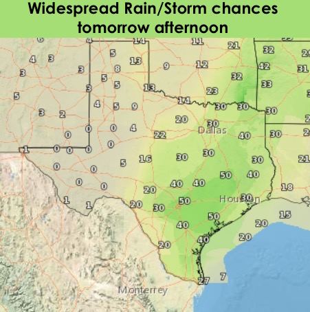
Our somewhat active weather week continues tomorrow with additional chances for seeing scattered rain showers and a few isolated strong to severe storms tomorrow afternoon. The approaching upper level disturbance which caused today’s storms will move into the state, and we could see a few strong to marginally severe storms develop along the dryline across the eastern panhandle, northwest and western north Texas tomorrow evening. The Storm Prediction center has placed this part of the state under a Marginal Risk for strong storms with small hail and gusty winds being the main threats. For much of the remainder of the state, scattered storms, some strong, are expected to develop by the afternoon hours. Lift from this system is expected to be relatively weak, so widespread severe weather is not expected. It’s likely this risk area will be modified a bit by tomorrow, and we’ll have those updates out for you by tomorrow morning.

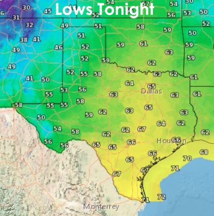
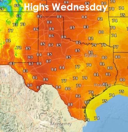
Lows tonight will be pleasant once again with mainly 50s and 60s expected across a majority of the state. Highs tomorrow will range from the mid to upper 80s across the panhandle and west Texas to the 70s and low 80s across north, central and the southern 1/2 of the state. Cloud cover and scattered showers across these regions will tend to keep temps from getting much warmer. A strong cold front will move through the state on Friday bringing temps back down to below average for Saturday, but then we pop right back up again by Sunday. We’ll have more details out on that, and additional rain/storm chances for Thursday, in tomorrow’s blogs!


0 Comments