
I’ve been chasing since the fall of 2008 and in six spring seasons 2015 marks the latest start to my chase season. While I’m still on the fence it looks like I may end up starting my season on Monday. A couple ingredients are coming together to support a marginal chase setup across the extreme Northeastern Texas Panhandle into Northwest Oklahoma tomorrow evening. One huge factor in this season’s extremely quiet start has been a lack of moisture. Throughout February and early March several strong cold fronts brought cool continental air into the Southern Plains. The cold fronts also pushed rich moisture way out into the Gulf of Mexico and Caribbean. It takes several days after a strong cold front for that moisture to make it back into the United States. Moisture recovery is difficult when you have cold fronts pushing it back out (south) every few days. We’ve finally seen a long enough stretch along with southerly winds that has allowed the richer moisture to advect northward from the Caribbean. The result will be three days of potential chases this week on Monday, Tuesday, and Wednesday. I’ll focus on Monday with this article and talk more about Tuesday and Wednesday later on.
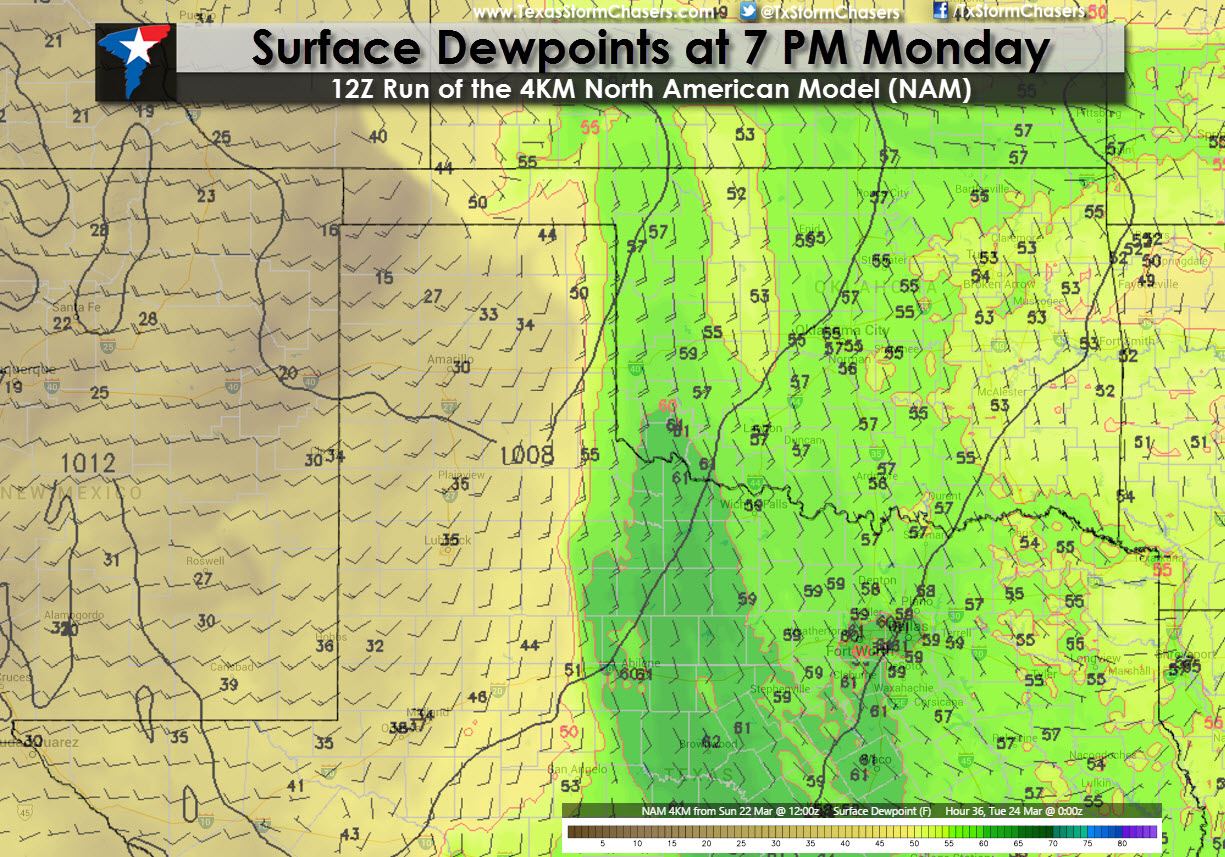
I’ll be using the morning run of the North American Model (NAM) to provide graphics explaining the setup tomorrow. Starting off with surface moisture at 7 PM on Monday a dryline will setup right on the Texas Panhandle/Western Oklahoma border extending south through West-Central Texas south through the Big Country. A strong capping inversion will keep thunderstorms from developing in the Big Country and Northwest Texas on Monday. Surface dewpoint values of 59-61 degrees will be present along the dryline in the Big Country with upper 50s in western/northwestern Oklahoma into southern Kansas. The wind barbs on the graphic indicate southeasterly winds sustained at 20 knots (25 MPH) with higher guests across western Oklahoma so that moisture will be streaming northward. For higher-end severe weather we typically need to see dewpoint values above 65 degrees so the relatively modest dewpoint values should keep any storm high-based meaning no to very limited potential for a tornado threat. I personally am not expecting tornadoes on Monday.
Since I’m not concerned with a tornado threat on Monday I’ll forgo detailing the low level wind profile. I will say that a relatively strong low level jet above the ground will be supportive of rotating thunderstorms. If we had higher dew point values and low level moisture tomorrow could easily become a tornado-type day (compared to a hail threat). However that seems unlikely. What those strong winds will mean for any storm is it could become quite organized albit high-based. Bulk shear values in the lowest six kilometers of the atmosphere will be around 45 to 55 knots in the northeast Texas Panhandle into northwest Oklahoma. The baseline we want to see for supercellular storms or more organized convection is 40 knots so the shear will be there. We’ll have good mid and upper level winds as well.

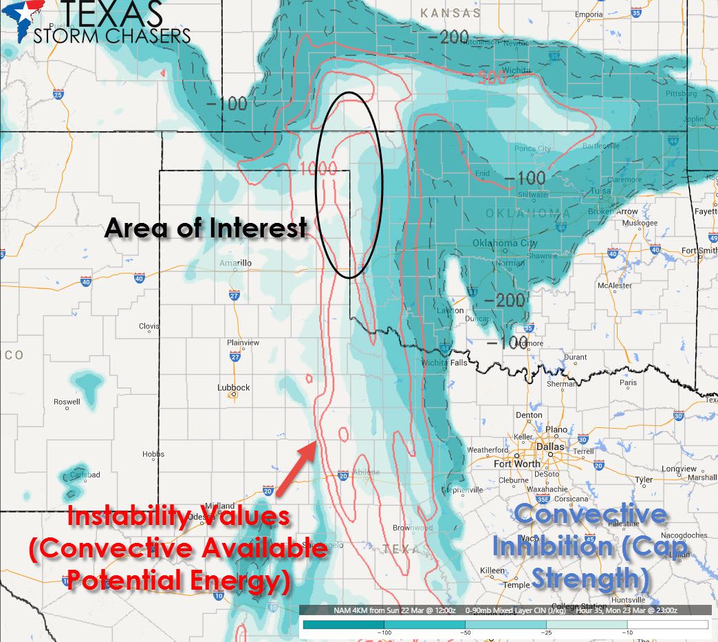
The primary way to measure instablity in the atmosphere related to thunderstorms is Convective Available Potential Energy or CAPE for short. With modest moisture in place we won’t see overly impressive CAPE values on Monday but there will be instablity in place. Right now it looks like we may see 1000 to 1500 J/Kg (joules per kilogram) of CAPE just east of the dryline tomorrow afternoon. Those values aren’t particularly high and are limited by the modest moisture. With relatively strong wind shear in place it should compensate some for the modest instability values. The main show breaker tomorrow could be a strong capping inversion. Shown in blue on the graphic the convective inhibition in the area of interest is going to be quite strong. We may not see any storms develop in northwest Oklahoma tomorrow afternoon because of the strong cap. We’ll likely see storms fire up well after dark in Kansas tomorrow night but that’s due to a different process and isn’t of chase interest. It’s going to be a close call whether or not we see the cap break tomorrow ahead of the dryline.
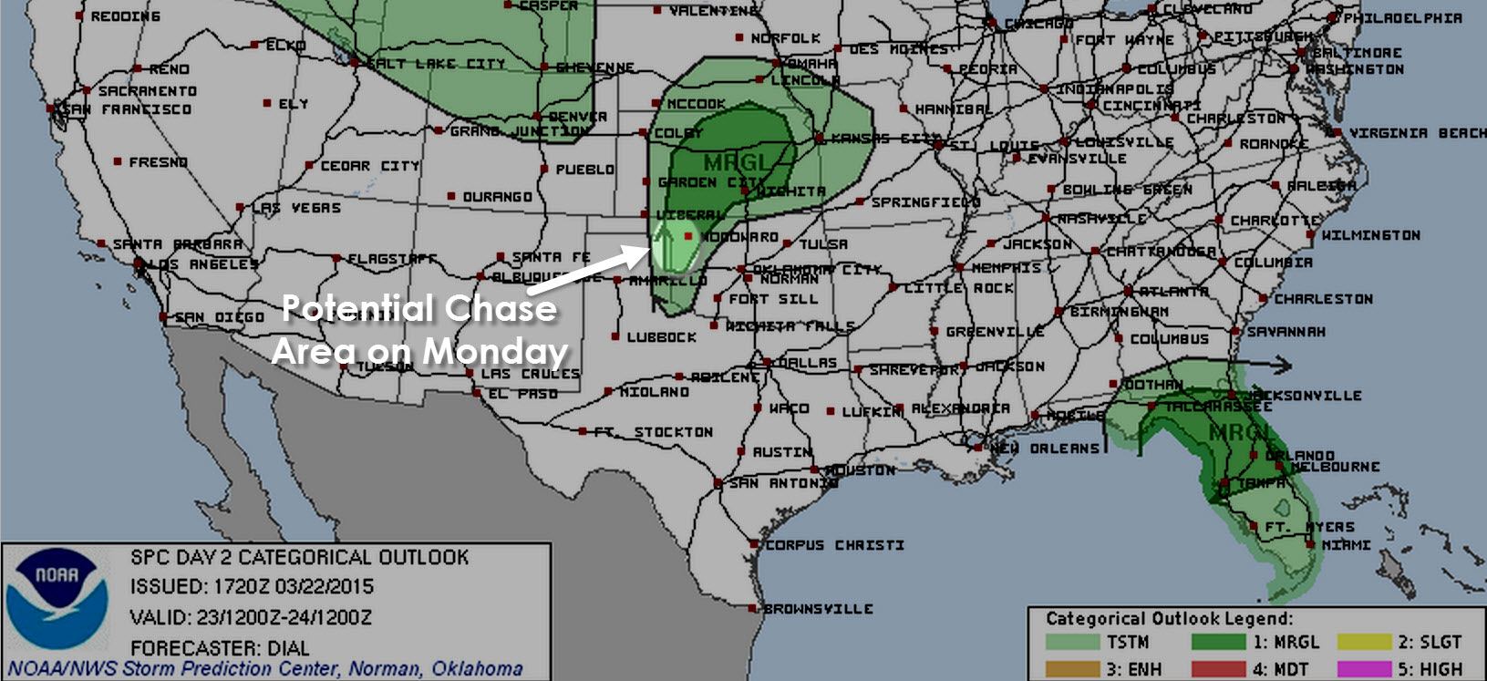
If the cap does break then the ingredients will be in place to support the possibility of one or two high-based supercell thunderstorms capable of producing large hail. Since storms would be high based the tornado threat would be minimal. With the strong shear in place along with just enough moisture any storm that goes could become a photogenic supercell. Another reason for me to chase is to test out equipment in my new car. I’ve been busy getting it ready all week and would prefer to test it out on a relatively ‘easy’ day before we get into more potent setups later this week. In fact I’ve got quite a bit to finish up on the car so I better wrap this up! If I do chase tomorrow my plan is to live stream video back to the website for the first time since 2012. I’ll leave you with the latest outlook from the Storm Prediction Center for Monday’s severe weather threat. It is a marginal setup but we’ll see how things look later tonight. If the cap looks like it will hold then I’ll sit tomorrow out with chasing expected on Tuesday and Wednesday. On the other hand if it looks like the cap will break I may venture out to northwest Oklahoma to see if Mother Nature will give me a present. We’ll see what happens!


0 Comments