
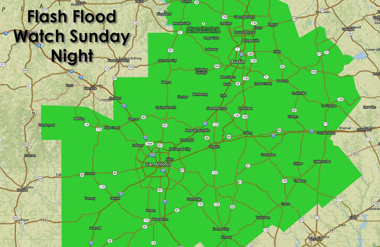
In an about face from last week’s winter weather issues we now face a new threat. A Flash Flood Watch will go into effect this evening through Monday for Central and South-Central Texas. This does include the Austin and San Antonio metropolitan areas along with the surrounding suburbs and towns. Several upper level disturbances will bring copious amounts of rain in the form of several waves beginning today and continuing through Monday evening. Precipitation intensity will increase tonight into Monday with widespread rain totals of 1 to 3 inches expected. Some locations could receive 6 inches of rain in a short period of time. Because of the increasing rainfall totals the National Weather Service in Austin has elected to issue a Flash Flood Watch to convey the risk for heavier rains and localized flooding. This is not expected to be a widespread nor significant flood event like the one experienced on Halloween in 2013. This threat is more of kind we expect to cause issues in the low-lying trouble spots. Jenny will have the full forecast out later this morning including who all will see rain and how much.
FLOOD WATCH
NATIONAL WEATHER SERVICE AUSTIN/SAN ANTONIO TX
437 AM CDT SUN MAR 8 2015
…LOCALLY HEAVY RAINFALL TONIGHT THROUGH MONDAY…
.A SERIES OF DISTURBANCES WILL INTERACT WITH A PLUME OF MOISTURE
FROM THE PACIFIC TO PRODUCE ROUNDS OF SHOWERS AND ISOLATED
THUNDERSTORMS ACROSS SOUTH-CENTRAL TEXAS TODAY THROUGH EARLY
MONDAY EVENING. THE HEAVIEST RAINFALL IS LIKELY TO OCCUR LATE
TONIGHT THROUGH MONDAY AFTERNOON. DRIER CONDITIONS WORK INTO THE
AREA MONDAY NIGHT FROM WEST TO EAST.
TXZ172-173-187-189>194-204>209-219>225-081745-
/O.NEW.KEWX.FF.A.0001.150309T0000Z-150310T0000Z/
/00000.0.ER.000000T0000Z.000000T0000Z.000000T0000Z.OO/
BURNET-WILLIAMSON-BANDERA-KENDALL-BLANCO-HAYS-TRAVIS-BASTROP-LEE-
MEDINA-BEXAR-COMAL-GUADALUPE-CALDWELL-FAYETTE-FRIO-ATASCOSA-
WILSON-KARNES-GONZALES-DE WITT-LAVACA-
INCLUDING THE CITIES OF…BURNET…GEORGETOWN…BANDERA…
BOERNE…BLANCO…SAN MARCOS…AUSTIN…BASTROP…GIDDINGS…
HONDO…SAN ANTONIO…NEW BRAUNFELS…SEGUIN…LOCKHART…
LA GRANGE…PEARSALL…PLEASANTON…FLORESVILLE…KARNES CITY…
GONZALES…CUERO…HALLETTSVILLE
437 AM CDT SUN MAR 8 2015
…FLASH FLOOD WATCH IN EFFECT FROM THIS EVENING THROUGH MONDAY
EVENING…
THE NATIONAL WEATHER SERVICE IN AUSTIN/SAN ANTONIO HAS ISSUED A
* FLASH FLOOD WATCH FOR A PORTION OF SOUTH CENTRAL TEXAS…
INCLUDING THE FOLLOWING AREAS…ATASCOSA…BANDERA…BASTROP…
BEXAR…BLANCO…BURNET…CALDWELL…COMAL…DE WITT…
FAYETTE…FRIO…GONZALES…GUADALUPE…HAYS…KARNES…
KENDALL…LAVACA…LEE…MEDINA…TRAVIS…WILLIAMSON AND
WILSON.
* FROM THIS EVENING THROUGH MONDAY EVENING
* WIDESPREAD 2 TO 4 INCHES OF RAINFALL IS EXPECTED WITH ISOLATED
POCKETS UP TO 6 INCHES.
* RAPID RUNOFF FROM THESE HEAVY RAINS COULD RESULT IN FLASH
FLOODING OF CREEKS AND STREAMS…LOW WATER CROSSINGS…URBAN
AREAS NORMALLY SUBJECT TO FLOODING…AS WELL AS A THREAT TO LIFE
AND PROPERTY.
PRECAUTIONARY/PREPAREDNESS ACTIONS…
A FLASH FLOOD WATCH MEANS FLASH FLOODING IS POSSIBLE IN OR NEAR
THE WATCH AREA. IF YOU ARE IN THE WATCH AREA…PLAN NOW FOR WHAT
YOU WILL DO IF FLASH FLOODING DEVELOPS. STAY INFORMED AND BE
READY TO ACT IF YOU SEE FLOODING OR IF A FLASH FLOOD WARNING IS
ISSUED.


0 Comments