
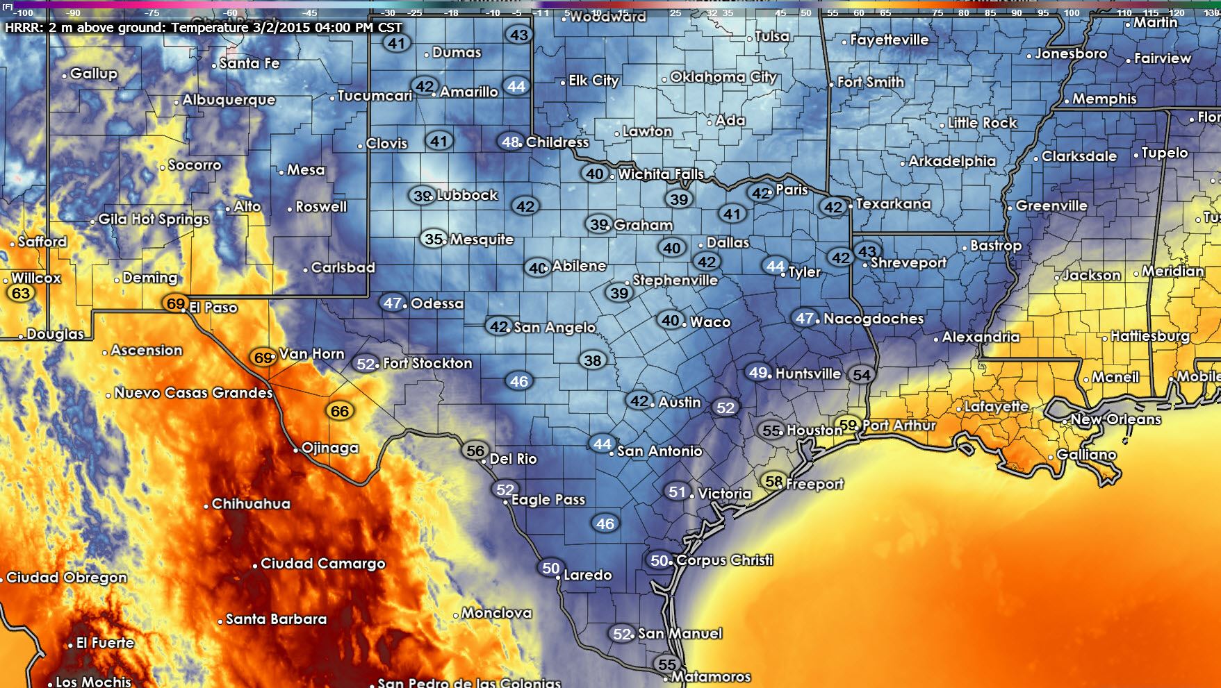
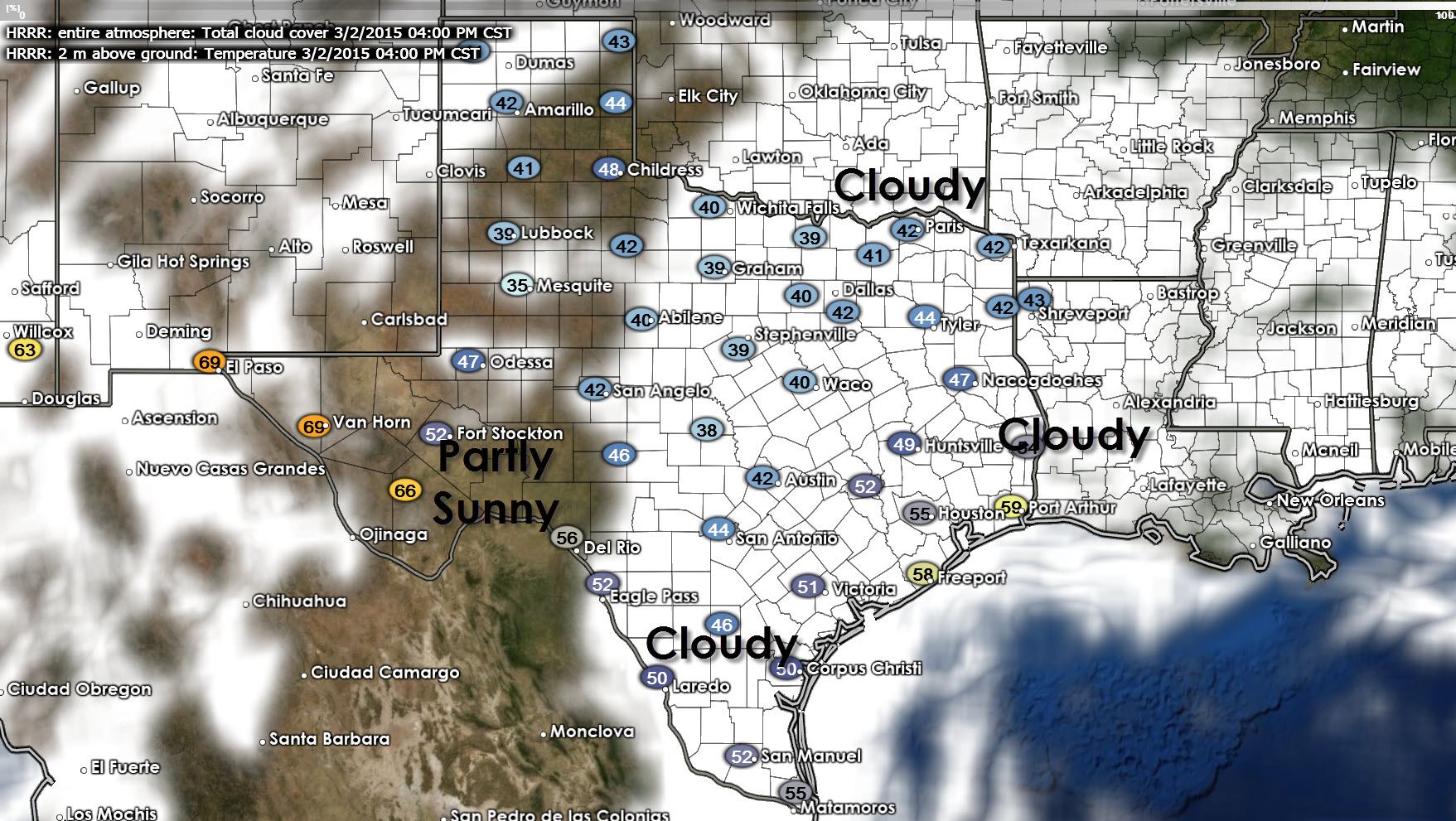
We’re starting off the new work week with low overcast and some light rain but we’re not dealing with a winter storm. Well, at least we’re not dealing with a winter storm today. That may not be true come Wednesday afternoon. Temperatures will still be cool by early March standards today but they will be a few degrees warmer than Sunday. By this afternoon we’re expecting mostly cloudy skies across the Hill Country, North Texas, Northeast Texas, East Texas, Southeast Texas, South-Central Texas, Deep South Texas, and the Rio Grande Valley. We may see some sun across the Permian Basin into the South Plains and West-Central Texas. High temperatures will range from the low 40s to the low 50s. Definitely cool for early March but again much better than what we dealt with last week. If it makes you spring-fans feel better Tuesday will feature high temperatures in the 50s, 60s, and 70s. Here are two forecast graphics for 4 PM this afternoon highlighting the high temperature forecast along with a simulated cloud projection.
Upcoming Arctic Blast and potential for Winter Storm on Wednesday
Can you tell I’ve been hinting at another round of cold weather? Well lets just say Mother Nature isn’t done with us just yet. Another powerful arctic cold front will begin arriving Tuesday Night and push south through Texas during the day on Wednesday. You’ll know the front has arrived when temperatures plummet into the 20s, 30s, to lower 40s with blustery north winds and a biting wind chill. Not surprisingly weather models have trended towards a quicker solution with the cold front’s timing. I would not be surprised if the front was pushing through Eagle Pass and Corpus Christi by 6 PM on Wednesday with all locations north of that experiencing winter-like temperatures. The freezing line could already be draped across the Hill Country into Central Texas into the Brazos Valley. That’s an important observation because we look to have precipitation falling at the time.
There is the potential for a winter weather event on Wednesday into Wednesday Night across the Permian Basin, Concho Valley, Big Country, Northwest Texas, North Texas, Northeast Texas, and even parts of Central Texas into the Brazos Valley. Uncertainty remains far too high to make an accurate accumulation forecast at this juncture. However there is the potential for accumulating freezing rain/sleet/snow to create travel problems by Wednesday Afternoon from the Permian Basin eastward through the Concho Valley into North Texas. That is not a sign that we could see significant accumulations but rather an indication that we believe there is a moderate chance of enough winter precipitation falling to create some issues. With several winter weather events over the past week I know many of you are already wanting to know how much will fall, where it will fall, how long with roads be icy, etc. I cannot tell you at this point – if I did my forecast would likely be completely wrong. Forecasting winter weather in Texas is difficult enough 24 hours out – and we’re still talking about an event over 2 days away!
What we’ll be watching for today is the arrival of this morning’s weather model guidance. There remains a good deal of model uncertainty about the placement and amount of precipitation that could fall with temperatures below freezing. A few models say this will be a non-event while other are projecting a major winter storm. Factors including the arrival of the sub-freezing air, timing and strength of the upper level storm system, availability of moisture for winter weather precipitation, and what type of precipitation all will play critical roles in the forecast. If we can get weather models to agree on at least some of these issues this morning we’ll be able to provide a much more detailed forecast this afternoon. Just realize this is another winter weather event that has the potential to cause travel impacts and issues related to that Wednesday Afternoon into Thursday (when temperatures will rise above freezing).
The best advice I can give you now is to check back for forecast updates frequently. Many novice or flat-out inaccurate social media groups will be posting scary weather model graphics trying to stir up a panic and get likes. We saw it with last week’s winter storm here in Texas and we’ve seen it all over the country. Always have at least two sources for weather information.
I’ll be doing a Google Hangout (Live Video Chat) with DFW Scanner’s John Burgdorf tonight at 8:30 PM talking about the potential for winter weather issues on Wednesday. Please join us then and we’ll do our best to answer some of your questions. You can find the video and chat page at https://www.youtube.com/watch?v=AjlzFfIxzZc


0 Comments