
Today will be the warmest day we see this week and possibly for the rest of February. The eastern two-thirds of Texas have started out cloudy this morning with areas of fog/mist. By lunch time we should see cloud cover starting to shift east but likely will stay cloudy along and east of I-35 all day. Temperatures will be spring-like today for everyone except Northeast Texas. Low 70s to upper 70s can be expected for almost everyone outside of Northeast Texas. We’ll even see low 80s across West Texas, the Concho Valley, into the Permian Basin. Enjoy it because there’ll likely be snow flying in some of those areas by Sunday night. Winds will be gusty out of the southeast as moisture is transported north. You can blame that moisture for the clouds that will hang in tough across East Texas today. Areas of light rain will also be possible along/east of I-35 this morning and in East Texas this afternoon.
Our main concern by far continues to be the timing of the arctic cold front. Unlike the past few systems it looks like we’ll have cold air in place ahead of any sort of precipitation. That means instead of having to wait for the cold air to arrive while its raining it will already be in place. Hence the reason we’re closely monitoring for any potential winter weather, but more about that in a bit. We’ll be using data from the North American Model (NAM) for surface temperatures. It usually does pretty well with shallow cold front’s and their timing. These cold fronts do have a tendency to move south more rapidly than what is anticipated. Don’t be shocked if the cold front ends up coming in a bit slower or faster than what these graphics show.
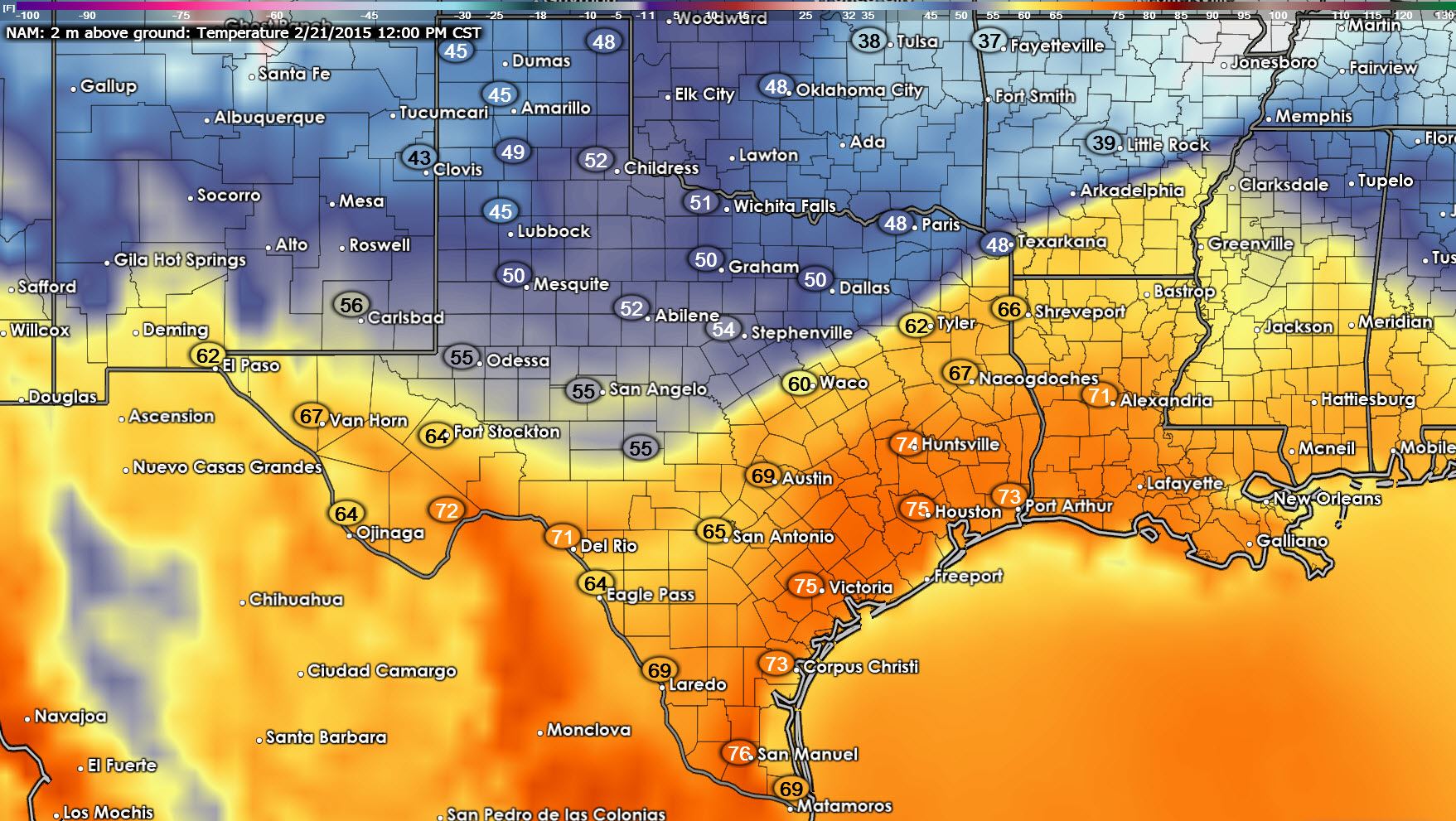
We’ll really end up seeing two surges of cooler air. The first one will begin arriving late tonight in the Panhandle and push south of the Red River early on Saturday. Temperatures will generally fall into the upper 40s to lower 50s. By noon on Saturday the NAM has this front extending from southwest of Odessa east towards Sonora northeast to Waco, Tyler, and Texarkana. South of the front temperatures will once again be warm with 60s and 70s. Temperatures north of the front will be cool with upper 40s to lower 50s. We actually may have enough instablity just ahead of the cold front for a thin line of thunderstorms to develop. At this time I think those will mainly be in Louisiana where a few severe storms will be possible tomorrow. We’ll keep an eye on the latest data in the event we end up having a marginal severe thunderstorm risk develop in East Texas tomorrow. At this point that seems unlikely due to a strong capping inversion that should keep a ‘lid’ on any robust storm development in Texas.
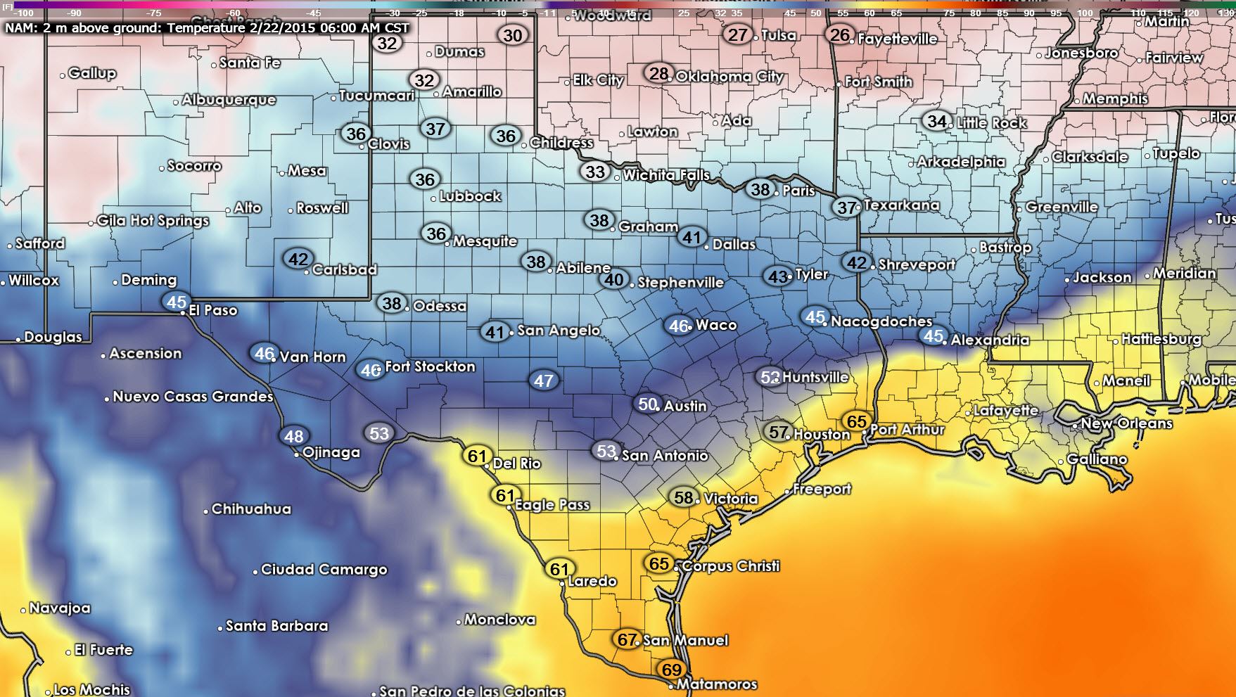
By early Sunday morning the initial cold front should extend from near Del Rio to Victoria to near the Houston Metro northeast to Jasper. For the most part temperatures will be in the mid 30s to mid 40s north of the cold front. The secondary and more significant arctic air is pushing south across the Texas Panhandle and Oklahoma at 6 AM on Sunday. Again don’t pay too much attention to the exact timing since we could see some timing adjustments. For those down in Deep South Texas or the Rio Grande Valley Sunday morning looks warm with 60s under a humid airmass.

By 9 PM on Sunday the initial cold front will be pushing into the Rio Grande Valley with the secondary arctic airmass surging south into the Permian Basin, Hill Country, Northwest Texas, and North Texas. The NAM has temperatures down in the lower 20s across the Texas Panhandle and West Texas with the freezing line near an Odessa, San Angelo, Abilene, Graham, Gainesville line. Central, East, South-Central, and Southeast Texas are in the lower to upper 40s at this point.
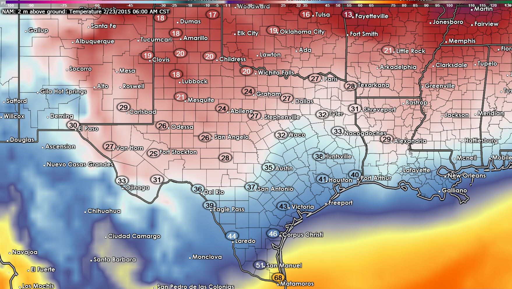
By 6 AM on Monday the Texas Panhandle and South Plains are seeing temperatures in the teens. The freezing line extends from near Del Rio northeast to Kerrville to Waco northeast to Tyler and Shreveport. That means all of the Texas Panhandle, West Texas, Permian Basin, Hill Country, North Texas, and Northeast Texas would be at or below freezing. This is an important note because we will likely have precipitation falling Sunday Night into Monday as an upper level storm system moves across the region. As always surface temperatures will play a big role in who ends up frozen over and who ends up with a cold rain. I caution you that these numbers and the eventual location of the freezing line WILL change several times as new weather model data arrives.
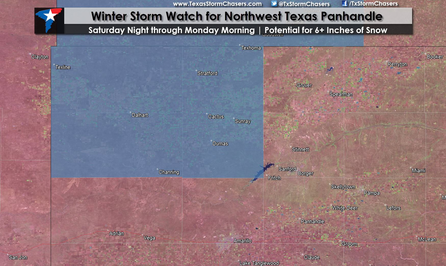
Starting off on Saturday Night the National Weather Service in Amarillo has issued a Winter Storm Watch for the northwest Texas Panhandle including Texline, Dalhart, Channing, Dumas, and Stratford. The Oklahoma Panhandle is also included in the watch. Their criteria for a winter storm watch up there is the expectation that six or more inches of snow will fall. The watch takes effect at 6 PM on Saturday and continues into the morning hours on Monday. It goes without saying that six inches of snow accumulating in an area with surface temperatures in the teens and twenties would cause snow-packed and slick roads. Keep that in mind if you’re planning a trip up on 287 or in the northwestern Panhandle this weekend. Lighter snow accumulations are expected in the remainder of the Texas Panhandle with one to three inches of snow possible Saturday Night through Monday Morning. Again some slick and snow-packed roads will be possible but this is not looking anything like the major winter storm that brought a foot of snow to Amarillo last month.
Further south and east the chance for winter weather is more complicated. We’re still 48-60+ hours out from any potential issues and there are still several unknowns that will determine how significant any winter weather potential ends up Sunday Night into Monday. At this time a winter mix, meaning freezing rain and sleet, is possible Sunday into Monday across portions of the South Plains, Rolling Plains, Northwest Texas, Concho Valley, North Texas, Northeast Texas, and East Texas. I’m not comfortable issuing an accumulation forecast at this time due to the unknown variables and distance time-wise from the event. However it does appear that there will be enough precipitation to potentially cause travel problems and even localized power outages. Temperatures at the surface and in the lower levels of the atmosphere will play a role in if the primary precipitation type is freezing rain or sleet. Either way some locations will likely receive significant accumulations. At this time the potential for accumulations of sleet/ice is most evident from the Rolling Plains eastward into the northwestern half of North Texas into Northeast Texas Sunday Night into Monday Morning. The forecast will change and so will the accumulation forecast. Since we’re still 60 hours out I’ll hold off on any accumulation graphics with this morning’s update. I’ll likely issue my first guess this evening assuming model data starts converging on a solution. A Winter Storm Watch may need to be issued for portions of the Rolling Plains, Northwest Texas, and North Texas later today should model data come in wetter and support a more significant winter storm. Most of Central, South-Central, Southeast Texas and everyone above freezing will not have issues with winter winter. A cold rain is looming though.
These statements have been issued by local National Weather Service offices across Texas to better inform residents of upcoming potential impacts from winter weather.
North and Central Texas
… Winter storm outlook for north and central Texas…
An upper level storm system is expected to move over north and
central Texas from Sunday night through Monday bringing a chance
of wintry precipitation across the region.
Precipitation is expected to develop across the region from west
to east Sunday evening. Precipitation may start out in liquid
form… however as temperatures drop Sunday evening and
overnight… rainfall is expected to change over to freezing rain
or sleet for parts of the region. Wherever temperatures are below
freezing… freezing rain and sleet accumulations will be possible.
The freezing line is expected to exist somewhere across north
central Texas during this event… complicating the forecast.
At this time… locations along and northwest of a line from
Comanche to Dallas to Bonham are the most likely to see
subfreezing temperatures while precipitation is falling… however
confidence in the exact position of the freezing line is somewhat
low at this time. Precipitation amounts are supportive of ice and
sleet accumulations that could cause travel and power problems
as early as Monday morning if temperatures are cold enough. As a
result… this winter storm outlook is being issued to highlight
the potential for travel and power disruptions from late Sunday
night through Monday evening.
Any significant wintry accumulations are expected to come to an
end from northwest to southeast Monday evening.
Check the forecast throughout the weekend as slightly warmer or
cooler temperatures will likely result in significant changes to
the impacts of any wintry precipitation across the region.
Northeast and East Texas
… A bitterly cold airmass will affect the four state region
Sunday night into Monday with winter precipitation expected across
a large portion of the region…
The leading edge of a strong Arctic airmass will begin to move
into the region late Saturday with reinforcing pieces of cold air
dropping south out of the Southern Plains Sunday into Sunday
night. Disturbances from the west will provide the lift necessary
for overrunning moisture to move back in the region on Sunday with
just a cold rain expected.
However… as we move into Sunday night… cold air advection is
strong in the lower levels of the atmosphere and this will allow
for the cold rain to transition over to mixed winter precipitation
across the region. While precipitation type is very uncertain at
this time… a mixture of freezing rain and sleet appears probably
across north Louisiana and much of northeast Texas… while further
north across southern Arkansas and southeast Oklahoma… a mixture
of sleet and snow will be possible. This precipitation is likely
to continue into Monday with many areas struggling to get much
above freezing during the day… if at all.
As the event nears… amounts will become more certain… as will
the precipitation type. Please stay tuned and continue to monitor
the weather forecast as this potential winter storm moves into the
four state region Sunday night into Monday.
Permian Basin into the Davis and Alpine Mountains in far Southwest Texas
… A mix of light freezing rain… freezing drizzle… and sleet
possible Sunday night into Monday…
A much colder airmass will move into the region Sunday and Monday
with increasing chances for wintry precipitation across much of
the area. This precipitation should begin as rain Sunday afternoon
then as temperatures continue to fall Sunday evening/night… rain
will change over to freezing rain and/or sleet generally north of
I-10. Portions of the Permian Basin could receive up to one tenth
of an inch of ice while other areas may only see a light coating.
Regardless… light ice accumulations are possible northeast of the
Pecos River and could result in dangerous driving conditions
across these areas.
Light ice accumulations have proven to be very problematic for
area travel… and it is advised to drive cautiously and allow
extra time to reach your destination.


0 Comments