
As with any potential winter weather event I always stress that forecasting any sort of winter weather potential in Texas is extremely difficult. Even 24 hours out there are several factors that can change the forecast dramatically. We’ll be talking about Sunday and Monday which is still 72+ hours out. What I tell you tonight could be completely different tomorrow and again on Saturday. The temperature in the lowest few thousand feet of the atmosphere, how much moisture is available for precipitation, and any lift available to assist the development of precipitation will all play critical roles in what we may or may not see from this potential event. Local media have started talking about this potential winter weather event so I’ll go ahead and start getting more detailed in my discussions.
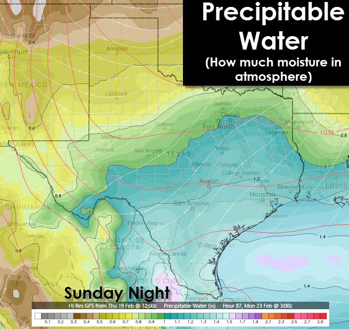
One main difference involving this upcoming system will be the cold air should already be in place. This is opposite of previous systems where we had to wait for the cold air to arrive. The upper air pattern next week does favor below average temperatures. Several storm systems look to impact the southern United States next week while the cold airmass is in place. How that all plays out will obviously determine our weather. The first system we’re watching will impact Texas on Sunday and Monday from the Panhandle south into the Hill Country including North, Central, Northeast, and East Texas. Liquid precipitation totals look to mostly be under half an inch but we could see an enhanced precipitation band set up with locally higher amounts.
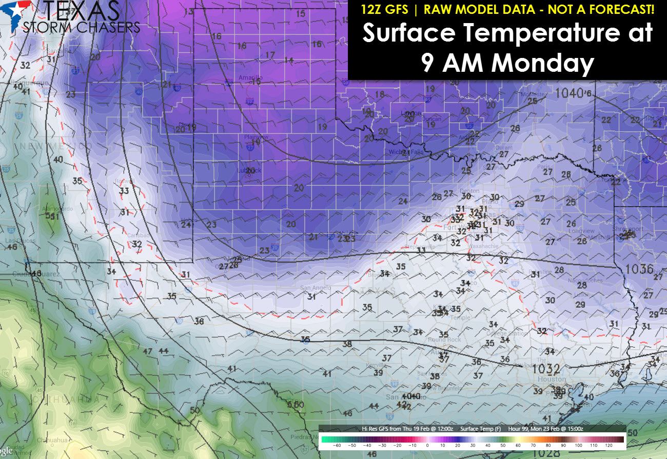
Current weather model data does indicate that precipitation will fall in the form of snow in the Texas Panhandle where accumulations should average 1 to 3 inches. Up to 5 inches of snow will be possible in the Northwest Texas Panhandle. I’m confident that the Panhandle will see snow as the primary precipitation type from this first event. Confidence in winter precipitation decreases further south across North, Central, Northeast, and East Texas on Sunday Night into Monday. Temperature profiles, storm system timing, and availability of moisture will all play critical roles in what transpires. There is the potential for a winter storm to bring freezing rain and sleet to portions of Northwest, North, Northeast, East, and even parts of Central Texas Sunday Night into Monday. I’m not going to dive into winter weather accumulation forecasts at this time. If everything does come together then we could see a high-impact winter storm across Northwest, North, Northeast, and parts of East Texas Sunday Night into Monday including substantial travel impacts and even some power outages. Likewise this may end up being a low-impact event if something doesn’t come together. Precipitation type looks to be sleet or freezing rain with ice accumulations. By ice accumulations I’m referencing an event like December 2013 that impacted North Texas. I am by no means saying I expect an event of that caliber – I’m just saying that’s what type of event this could be versus a snow event.
South of the freezing line precipitation would fall in the form of a cold rain across Southcentral and Southeast Texas. Without a doubt this is an event where everyone should check back for forecast updates several times as we head into the weekend.
High Confidence
Another arctic cold front will bring cold temperatures back to Texas next week.
The cold front should arrive Saturday Night into Sunday.
Moderate Confidence
Several storm systems will impact Texas while the cold air mass is in place with episodes of winter weather possible.
One to three inches of snow will occur in the Texas Panhandle this weekend. Localized snow accumulations up to five inches will be possible in the northwest Texas Panhandle.
Sleet/Freezing Rain will be possible on Sunday and Monday in Northwest Texas, North Texas, Northeast Texas, East Texas, and perhaps parts of Central Texas.
Low Confidence
Where the freezing line will end up for the precipitation event on Sunday and Monday. It will play a critical role in who sees a significant winter weather impacts versus a cold rain. Even a 20 mile shift will make or break the forecast for some.
How much precipitation will fall Sunday and Monday especially in locations that are below freezing.


0 Comments