
We have not seen any radical changes with the upcoming forecast since last night. I do anticipate that a plethora of Winter Storm Warnings and Winter Weather/Travel Advisories will be issued this afternoon. At that point the watch/warning map across Texas will light up like a Christmas tree and we’ll have more detailed and regional accumulation forecasts. I do want to point out that it only takes a small amount of freezing rain or sleet to make roads skating rinks. So 0.50″ of sleet/ice accumulation is quite significant. Not only will that make most roads extremely slick but could also make a few power lines come down with the increased weight of ice. That concern is highest where we have the Winter Storm Watch in effect. By the way the watch has been expanded south about two rows of counties in North Texas and does include additional cities. See the North Texas portion of this post for more information on that.
A couple housekeeping.notes
1) While we are now getting close to this winter weather event we’ve still got 36-42 hours before it really cranks up in the heartland of Texas. There will still be forecast adjustements today.
2) We’ll see a lot of Winter Storm Warnings/Advisories issued this afternoon including in areas not under a Winter Storm Watch. The watch area is where confidence is highest that significant issues are expected. Surrounding the watch area there will likely be an advisory issued later today across parts of the Permian Basin, South Plains, Northwest Texas, Northeast Texas, parts of the Hill Country, and parts of East Texas. Those folks will see more minor accumulations of winter precipitation but even minor amounts can cause travel impacts.
3) We’re hosting a live video discussion along with a question/answer session tonight at 8:30 PM with DFW Scanner’s John Burgdorf. We’ll be using Google Hangouts which streams live on YouTube. We’ve got a link at the top of the website where you can watch and join in on the conversation.
Concho Valley, West-Central Texas, North-Central Texas
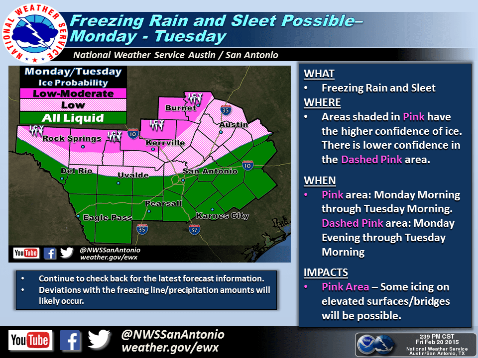
A Winter Storm Watch remains in effect Sunday Evening through Monday Evening for the Concho Valley, West-Central Texas, and much of North Texas. The watch has been expanded southward about two rows of counties this morning. A few (well, a lot) of cities included are San Angelo, Brady, Sweetwater, Abilene, Brownwood, Stephenville, Breckenridge, Graham, Bowie, Mineral Wells, Gainesville, Decatur, Denton, Fort Worth, Arlington, Dallas, McKinney, Sherman, Bonham, Paris, Sulphur Springs, Greenville, Terrell, Canton, Athens, Corsicana, Waxahachie, Hillsboro, Waco, and Lampasas. These areas are where confidence is at least moderate that accumulating freezing rain and sleet will cause quite a mess on roadways on Monday. This past evening’s weather model data did indicate that some of this wintry mess may actually continue into Tuesday now. Regardless temperatures will likely remain below freezing into Tuesday. Since we’re still 36 hours out from the event some chances are bound to occur. A narrow, but enhanced band of sleet and freezing rain may develop across North Texas on Monday. Right now it looks like this would be just west/north of the D/FW Metroplex. Accumulations of sleet in this zone could approach one inch. Remember it only take 0.01″ of ice accumulation to turn roads and bridges into a skating rink. 1 inch of sleet accumulation is quite significant. Stay tuned for forecast and accumulation refinements. We’ll be doing a live video chat plus a question and answer session tonight at 8:30 PM with D/FW Scanner over on YouTube Live. Click the link at the top of this page and bookmark it if you’d like to participate.

Texas Panhandle
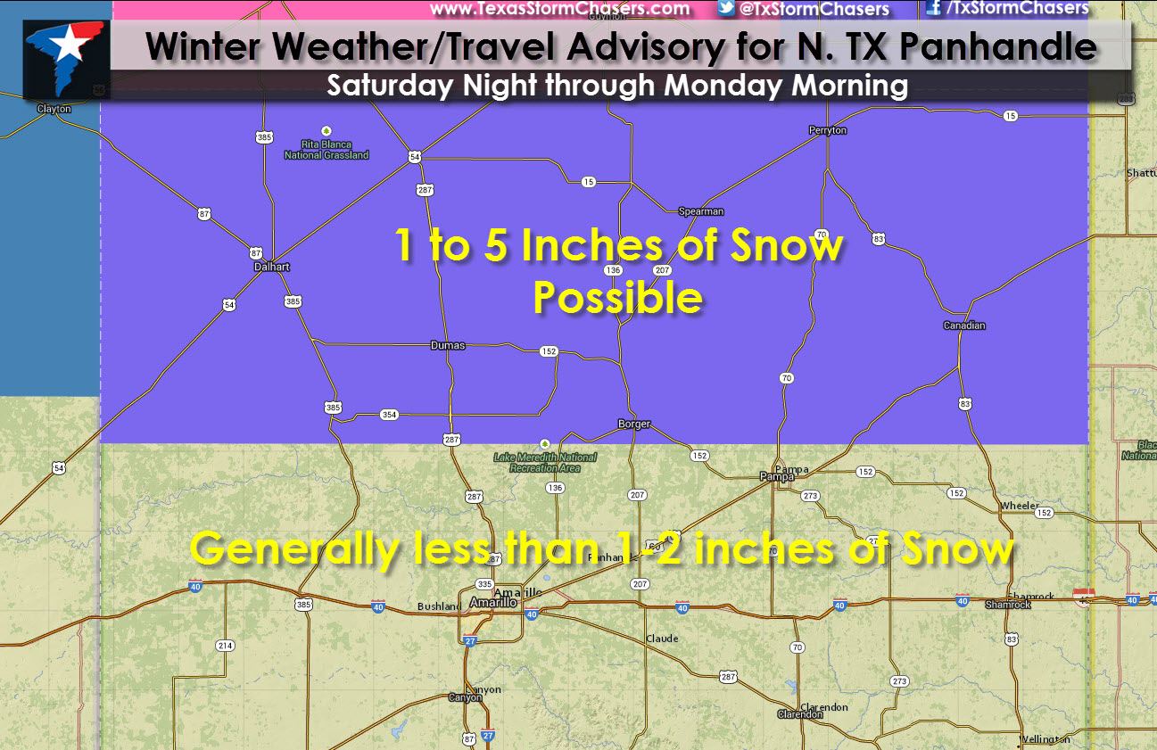
A Winter Weather Advisory goes into effect at 6 PM tonight and continues through the morning hours on Monday for the northern Texas Panhandle. Dalhart, Dumas, Borger, Spearman, Perryton, and Canadian are a few towns included. At this time the advisory does not include Interstate 40 or Amarillo. 1 to 5 inches of snow will be possible across the advisory area with the heaviest snow near the Oklahoma Panhandle. Roads will become snow packed late tonight into Sunday across the northern Texas Panhandle. Lighter snow with minor snow accumulations will be possible across the remainder of the Texas Panhandle. Some slick spots will be possible. We’ll continue to analyze data today as any southward shift in the heaviest snows would result in the accumulation forecast going up.
Permian Basin into the South Plains (West Texas)
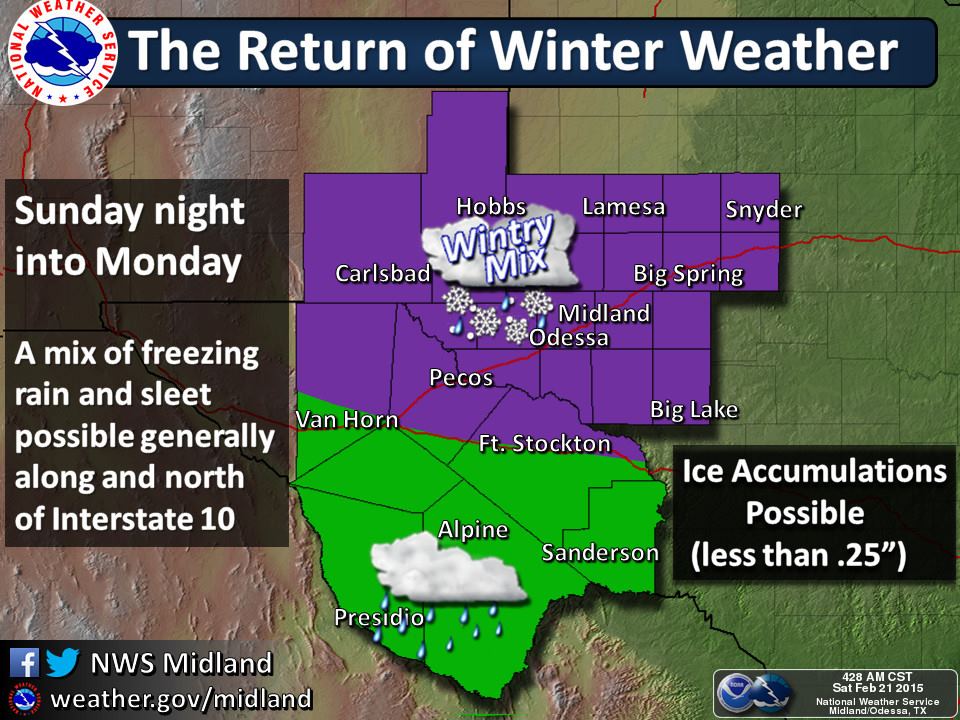
There are no winter storm products in effect at this time. I do anticipate the northern Permian Basin, South Plains, and Rolling Plains will see a winter weather advisory issued this afternoon for Sunday and Monday. As temperatures fall below freezing and an upper level storm system moves in we’ll see precipitation develop. At this time it looks like the primary frozen precipitation type will be sleet or freezing rain. Snow may occur closer to the Texas Panhandle and simply a cold rain where temperatures remain above freezing in the southern half of the Permian Basin. Some slick roadways will be possible but we’ll talk more about that when we see the advisories issued this afternoon.
Central Texas into the Brazos Valley
Temperatures may fall below freezing in the northern portions of Central Texas into the Brazos Valley Monday Night. Light precipitation may still be ongoing which could change over to a light freezing rain or sleet. At this time no winter weather products are in effect as this portion of the event is still two days away. We may see very minor ice accumulations Monday Night but all that will depend on trends over the next day. If the airmass is colder than anticipated then the freezing line would be further south. Likewise a warmer shift in model guidance or less moisture would effectively result in no winter weather. Stay tuned for forecast updates this weekend. By far the most significant ice threat will be further north.


0 Comments