
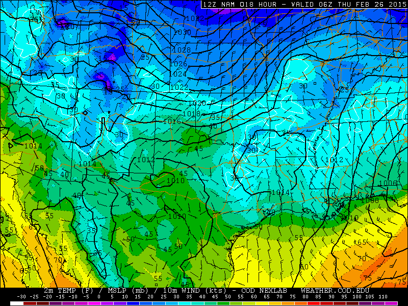
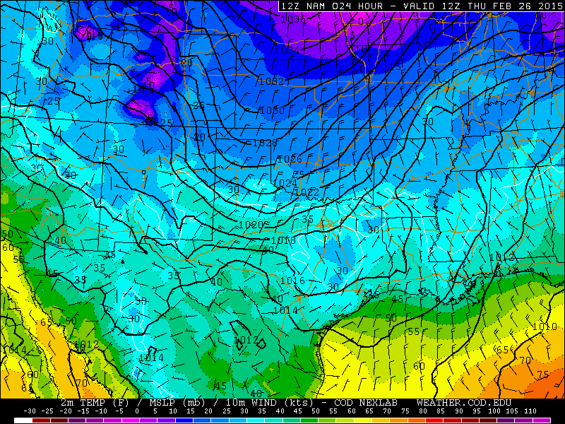
After a tranquil evening, another strong arctic front moves through with cold air lingering across most of the state through at least late Saturday. We will also have a few chances for seeing additional snowfall across parts of the panhandle, rolling plains, Big Country, northern Hill Country and into northern Texas. The cold front will begin pushing through the panhandle tonight and should be arriving across parts of west central Texas and north central Texas by early tomorrow morning. The front is expected to make it into central Texas by mid afternoon and along the central to upper coast by around sundown. The front will likely cross into the Rio Grande Valley region by Midnight tomorrow. This cold air will be sticking around through at least early Sunday, so get ready for it! Today was about the warmest day you’ll see until we get into next week.
Cold Front my Midnight Tonight
Cold Front by 6am Thursday
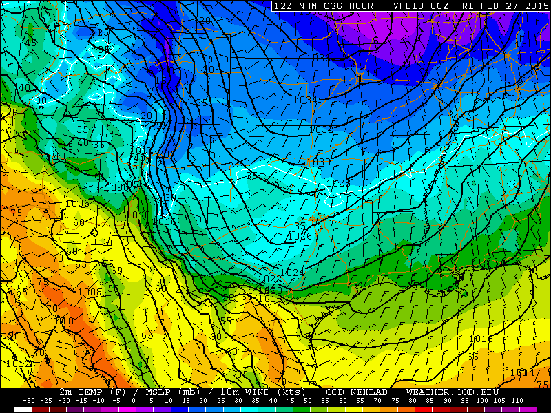
Cold Front by 6pm Thursday
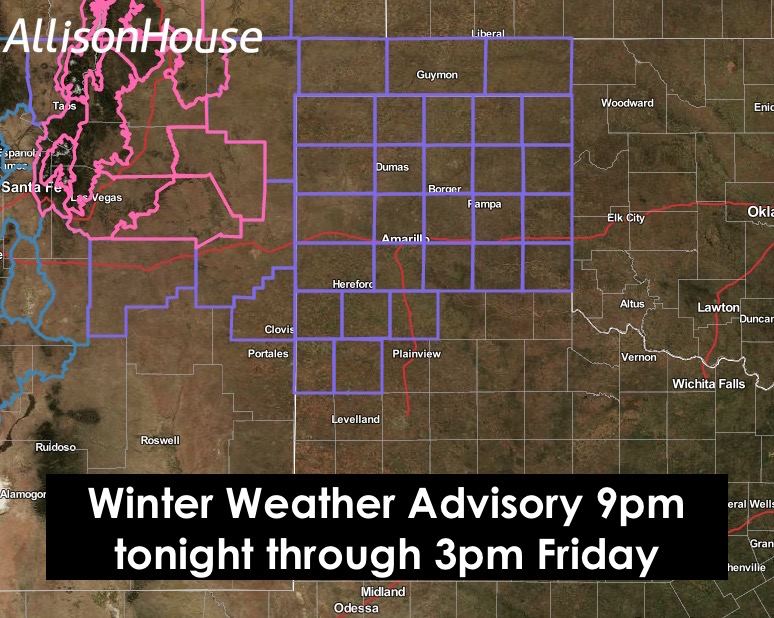
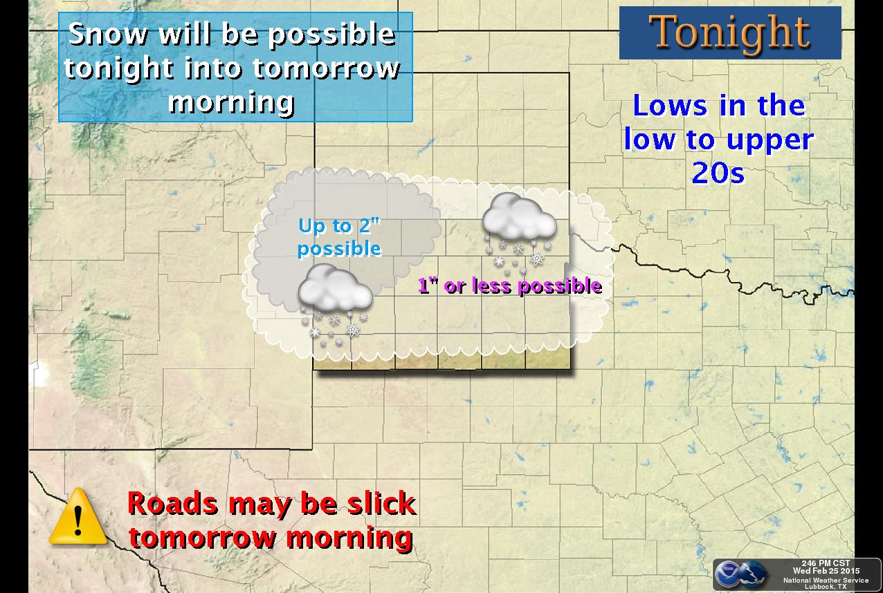
For the Panhandle Region: Snow is expected to arrive in two batches…the first being tonight into tomorrow morning, and the second batch arrives late tomorrow night and through Friday. A Winter Weather Advisory has been issued for the region and it’s effective from 9pm this evening through 3pm Friday to cover both snow events with minimal confusion, even though there will be a break between the two. The precip is expected to begin as rain tonight across the western panhandle and then switch over to all snow after midnight. Only light accumulations are expected tonight for most, with the heaviest snow totals up to 2 inches expected across the far western panhandle. Lubbock and Amarillo will likely see maybe 1/2 to 1 inch overnight at the most.

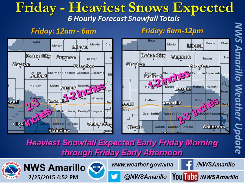
 For Friday: Heavier snow will be possible beginning early Friday morning and lasting through the evening. Highest snow totals should be in the 4 to 5 inch range by the time the system has moved east Friday evening with Lubbock and Amarillo both in the 2-3 inch range with some localized higher totals possible. I like how the folks at NWS Lubbock added the little milk and bread graphics, but I think they forgot the eggs for the French toast!! 😀

 For northern Texas…and this includes the Dallas/Ft. Worth metroplex: There’s a chance for a light dusting of snow after sunrise tomorrow generally along and north of I-20. Since the precipitation is expected to be light and all snow, minimal travel impacts are expected. Could see a few slick spots on overpasses and rural roads, mainly from whatever is leftover from yesterday and today’s sleet and snow, but overall no major impacts to your commute tomorrow morning. Friday, there is greater potential for accumulating snow in the areas outlined in purple on the map below. We won’t go into a great amount of detail yet on this next snow event since we are still over 24 hours out, but we could see some minor accumulation and a few impacts by Friday afternoon from this next system. Please continue to check back for details.

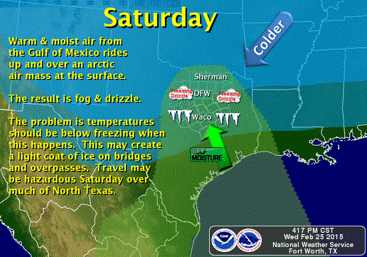
But wait…there’s more! By late Friday into Saturday, we’ll begin to see the return of moisture in the area…not necessarily at the surface, but up between roughly 3,000 to 6,000 ft which will basically sit on top of the arctic surface air and create a chance for some light freezing drizzle across much of north and central Texas between Waco, Dallas and the Red River counties. Don’t want to get into too much detail on that just yet either, but be aware that there could be some slippery roads early Saturday morning.
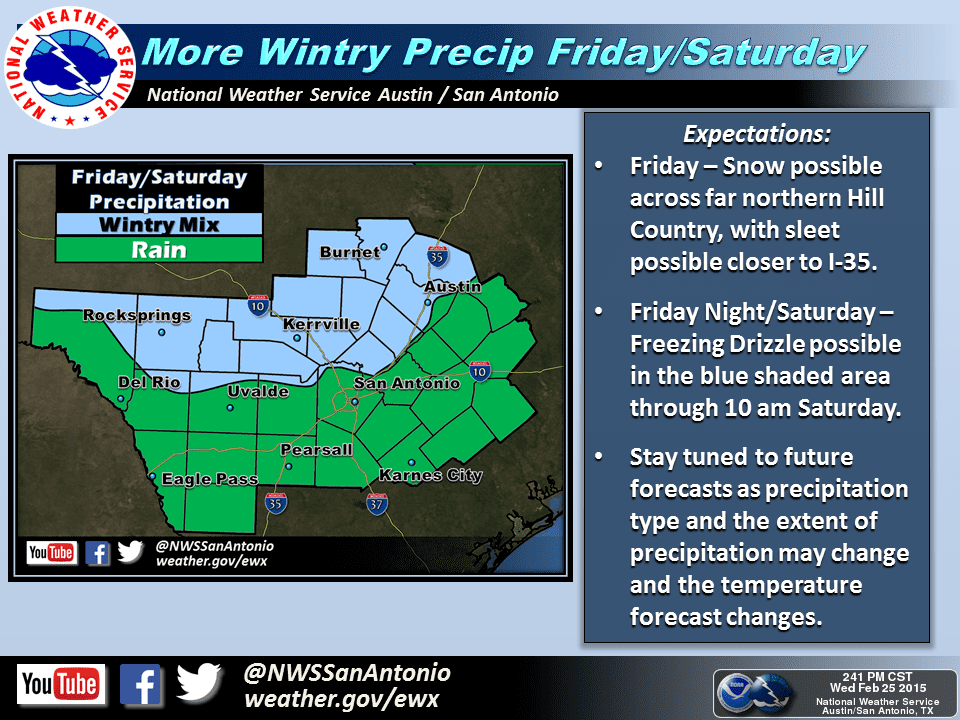
Northern Hill Country: Friday through Saturday also brings the northern Hill Country a chance at seeing a light snow Friday and a chance for some freezing drizzle late Friday into Saturday morning. This would mainly affect the areas north and west of Austin…west of the I-35 corridor, with the freezing rain more likely right along the I-35 corridor than further west. Again, we’ll have more details out on that as it gets closer.
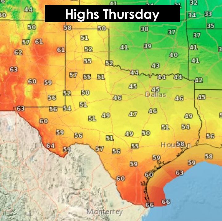
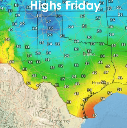
 Here’s a look at tonight’s lows and the highs expected tomorrow and on Friday. Winds will be gusty behind the front tonight and early tomorrow leading to brutal wind chills in the single digits across the panhandle, teens across the rolling plains and low 20s for north and parts of central Texas by tomorrow afternoon. It’s beginning to feel like we’ve had the entire winter season in one week!


0 Comments