
With the initial round of rain and winter weather out of the way…all eyes will be on the next round of wintry precip expected to develop in the wee hours tomorrow morning across far west Texas. This evening’s blog will lay out the impacts expected overnight and into early tomorrow morning by region.

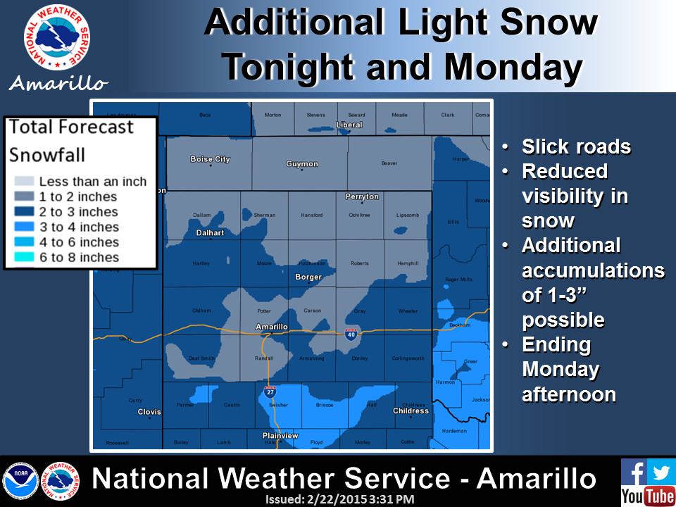
Panhandle/Rolling Plains: Several inches of snow has already fallen across the northern panhandle…with Dalhart receiving what appears to have been the bulk of the snow at 4.3 inches! All precip has ended for now, but we have more light snow on the way tomorrow as the next wave of upper level energy arrives. Light snow/sleet mix is expected to develop after 6am tomorrow morning with additional accumulations of 1 to 3 inches are possible…this time with the snow focus this time shifting a bit further south and east across the southeastern portions of the panhandle and down into the rolling plains.
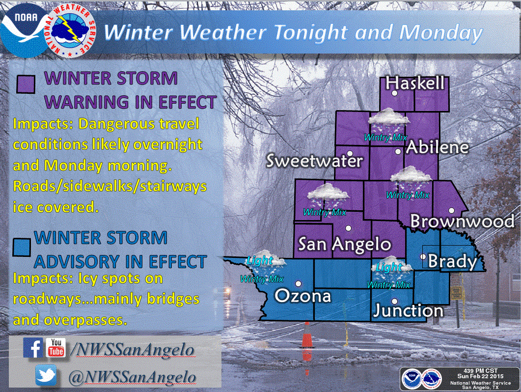
West Texas: With the initial band of winter weather heading into north east Texas, all eyes will be on the next round of wintry precip expected to develop in the wee hours Monday morning across western Texas. With temperatures already below freezing across the Permian Basin, Rolling Plains, Big Country/Concho Valley and northern Hill Country region, any precipitation that falls will be frozen. A warm layer aloft will keep most of the precip across this region from falling as all snow, so expect that most of what falls will be a winter mix of snow and mostly sleet. Wind chills will be brutal and down into the teens overnight. Travel overnight across western Texas will be extremely hazardous and is not recommended!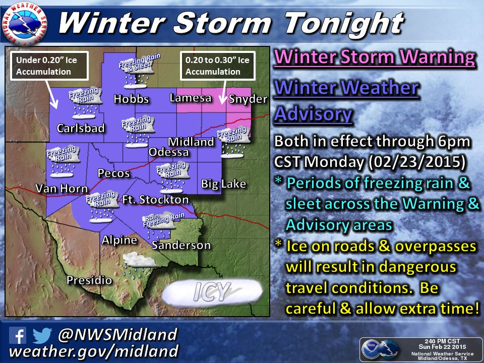
North Texas: For tonight, freezing drizzle is expected to remain in and around north central Texas overnight. It won’t be heavy, but could add to black ice conditions on the roadways overnight. During the day tomorrow, the previous forecasts continue to be on track for anywhere from 1/2 to 2 inches of sleet/ice accumulation across much of north Texas by tomorrow afternoon. Where convective bands of sleet set up tomorrow will determine who gets the greatest amount of accumulation. Unfortunately, it’s nearly impossible to forecast to that details, but we anticipate that will be across the northern portions of the DFW metroplex. The bulk of the next round of winter weather will arrive between about 3am for the western portions of north central Texas, to around 5am to 8am across the DFW metroplex. Most of the heavier sleet will fall within about a 5 hour window ending before noon. Residual light drizzle will impact the area through the afternoon hours. Many roads and bridges will have already frozen over from tonight’s precipitation, and whatever doesn’t melt off or evaporate with tonight’s winds, will refreeze and just add to the expected impacts. Travel is expected to be extremely hazardous around the region tomorrow morning. Staying indoors and off the roads is highly recommended. South of the metroplex, icing accumulations will be lighter and impacts will be significantly less. Not saying there won’t be some slick spots, but they are not anticipated to be widespread.

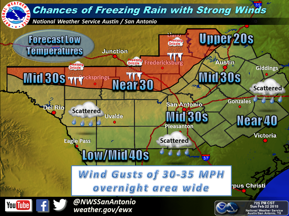
Southwest and Central Texas: Winter weather impacts will be felt as far south as Del Rio, Rocksprings, Kerrville, Fredericksburg, Austin and Georgetown. Impacts are expected to be mainly light freezing rain and freezing drizzle which may lead to icy patches on some bridges and roadway. By far, the greatest impacts will be felt further north…mainly along and north of the I-20/30 corridor.
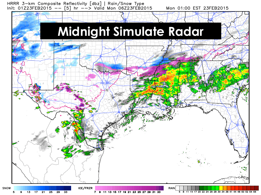
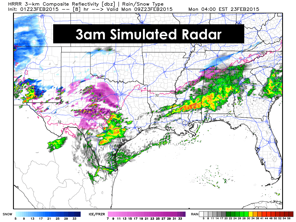
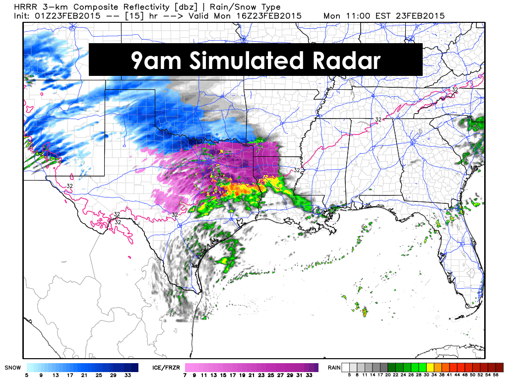
Here’s a look at the latest forecast model graphics for the overnight hours. We expect to see significant ramping up of precip between midnight tonight and 9am tomorrow. We can’t stress this enough…please stay off the roads overnight if you don’t have to travel. Same thing goes for tomorrow morning across any of the highly impacted areas in north central Texas. A great many school districts in the DFW metro have already announced closure, so hopefully non-critical businesses will follow suit and that will help lessen the chances for major accidents and help TxDot road crews get the roads cleared as quickly as possible.


0 Comments