
As I continue to emphasis the storm system we’ll be dealing with tonight into tomorrow is very dynamic and strong. It may do some things we’re not expecting and that’s why we need to be prepared to make forecast adjustements as needed. Earlier today I was downplaying the potential for travel impacts across North and Northeast Texas Wednesday Morning. While I still believe we’ll see most of the snow melt during the afternoon hours on Wednesday it is becoming apparent we could be dealing with slick roads and bridges during the morning hours tomorrow in the D/FW Metroplex north to the Red River including Gainesville, McKinney, Sherman, east to Bonham and Paris south to Interstate 30 in Northeast Texas up to Texarkana. At this time I am not making any accumulation forecast changes but they may need to be increased along the Red River north of the D/FW Metroplex as new model data arrives over the next two hours. At this time I believe 1 to 4 inches of snow is likely in the D/FW Metroplex with the higher amounts across northern D/FW and lighter across southern D/FW. We may see 3 to 5 inches of snow northeast of the D/FW Metroplex into Northeast Texas in an area otherwise dominated by 1 to 3 inches of snow.
Surface temperatures now look like they’ll be at or just above freezing across the D/FW Metroplex as snow falls. This dynamic system has the potential to produce heavy wet snow during the morning commute on Wednesday. Because the snow could be heavy we do anticipate problems on roadways and especially on bridges. This will be a bigger problem across the northern half of the D/FW Metroplex to the Red River based on the current data. Plan on it taking longer to get where you’re going tomorrow morning. Temperatures will rise well above freezing after lunch in D/FW and snow will quickly melt off roads. This will NOT be as bad of an event as Monday and impacts should only last a few hours.
Here are a series of images from the 0Z (6 PM) run of the High Resolution Rapid Refresh. This is a pretty reliable high resolution weather model that is run every hour. These simulated radar images shouldn’t be taken to heart as there will likely be some differences from the real thing. Still I think it has a pretty good idea of where we’ll be seeing precipitation. Blues and purples indicate snow with greens and yellows indicating rain.
EDIT: Graphic timing captions were off. We’ve corrected the error.

Simulated Radar at 3 AM

Simulated Radar at 6 AM
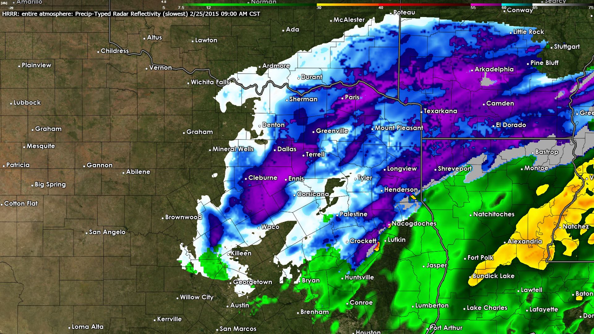
Simulated Radar at 9 AM
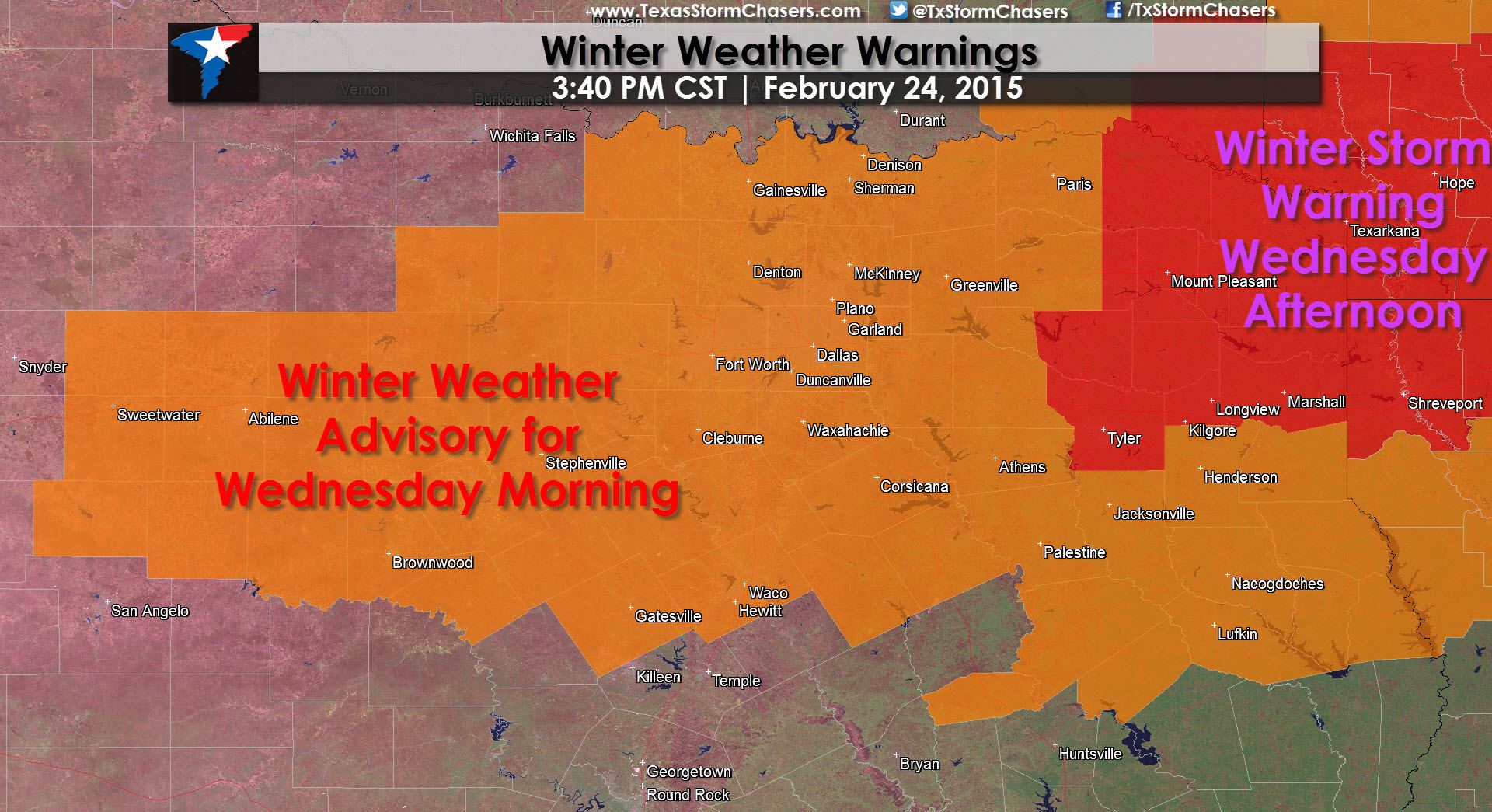
Winter Weather Warnings Summary
A Winter Storm Warning is in effect from Wednesday Morning through Wednesday Afternoon for Northeast Texas including Mt. Pleasant, New Boston, Texarkana, Marshall, Longview, and Tyler. Snow accumulations of 2 to 5 inches will be possible along with minor sleet accumulations. Slick roads and bridges are possible as snow falls but should clear up by late afternoon.
A Winter Weather Advisory is in effect late tonight through Wednesday Morning for parts of the Big Country and North Texas. Rotan, Sweetwater, Abilene, Brownwood, Comanche, Graham, Gainesville, Fort Worth, DAllas, Cleburne, Corsicana, Waco, Greenville, Paris, and Palestine are a few cities included. This is an upgrade from the Winter Storm Watch previously in effect. Snow accumulations of 1 to 4 inches will be possible with up to 5 inches of wet snow possible north of the D/FW Metroplex to the Red River. Roads and bridges could become slick and hazardous while snow falls during the morning commute but should quickly clear up in the afternoon hours.
A Winter Weather Advisory is in effect from late Wednesday Morning through Wednesday Afternoon for East Texas including Henderson, Nacogdoches, Lufkin, and Crockett. Up to one inch of wet snow will be possible on grassy and elevated surfaces. Little to no travel problems are anticipated.


0 Comments