
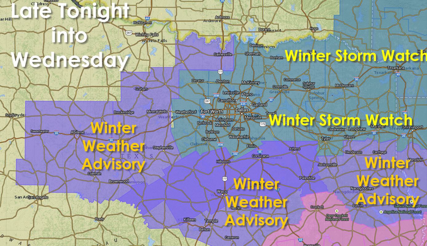
A Winter Storm Watch is in effect for the central and eastern portions of North Texas and Northeast Texas. Decatur, Granbury, Cleburne, Waxahachie, Fort Worth, Denton, Dallas, McKinney, Sherman, Paris, Clarksville, New Boston, Texarkana, Mount Pleasant, Linden, Marshall, Longview, Tyler, Mineola, Sulphur Springs, Greenville, Emory, Canton, and Terrell are a few cities included in the watch area. A localized but significant band of snow accumulations will be possible generally from 4 AM through 10 AM Wednesday in the D/FW Metroplex. Earlier to the west and later to the east. Uncertainty remains high but there is the potential for 2 to 4 inches of snow in parts of the watch area. Changes to the accumulation forecast are likely as we head into this afternoon. Check back for forecast updates today!
A Winter Weather/Travel Advisory is in in effect for the Big Country, all of North and parts of Central Texas. Rotan, Sweetwater, Abilene, Ballinger, Baird, Coleman, Albany, Brownwood, Gainesville, Bowie, Jacksboro, Graham, Mineral Wells, Stephenville, Comanche, Gatesville, Waco, Corsicana, and Athens are a few cities included in the advisory area. Confidence in significant accumulating snow is lower than in the watch area but some locations may see up to 2 inch of snow with most locations seeing seeing a dusting up to one inch. Changes to the accumulation forecast are likely as we head into this afternoon. Check back for forecast updates today!
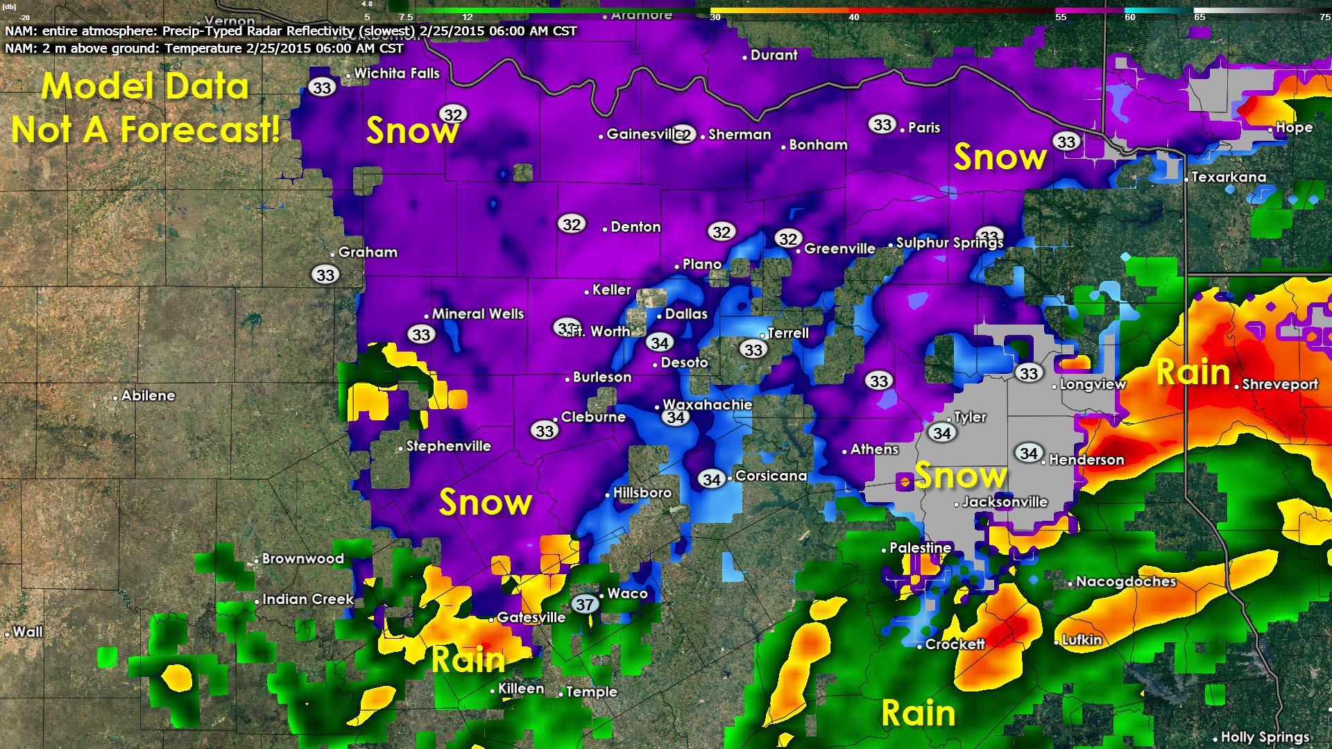
We still have quite a bit of uncertainty and varability regarding the upcoming winter weather potential on the first half of Wednesday. This forecast is so difficult because we will be depending on the track of a low pressure system along with pieces of energy in the atmosphere. For example there’s a small piece of energy just off the coast of Southern California this morning. Some of the models pick up on this but others seem to have missed it completely. One model that picked up on it was the NAM which shows a fairly substantial snow event tomorrow morning in North Texas. The Global Forecast System (GFS) did not pick up on that piece of energy and is much warmer and about 50 miles south with the heaviest precipitation.
Overall my confidence has increased that some of North Texas and Northeast Texas will see snow on Wednesday Morning. That’s a pretty good bet now. Convective elements will support areas of thunder snow (thunderstorms that produce snow) which would produce very heavy snowfall in localized areas. Another question is where the heaviest band of precipitation (possibly in the form of heavy thundersnow) will set up on Wednesday Morning. There is still about a 50-75 mile range being shown across North Texas (mainly the watch area). We’ll likely see most of the watch upgraded to a Winter Weather Advisory later this morning but we may see a portion upgraded to a Winter Storm Warning for the risk of heavy snow. Regardless of any accumulation tomorrow morning we’ll see temperatures rise into the 40s by the afternoon causing most snow that falls to melt. Surface temperatures while the snow is falling should be just above freezing, but we’ll still likely see it cause slick roads and bridges where heavy snow and thundersnow falls just because of how wet and how quickly the snow falls.
This is a very dynamic forecast (much more so than the one for Monday). We could have substantial forecast changes if the low ends up tracking differently than we expect. Be sure to check back several times today and tonight for the latest forecast here on our website and on social media.


0 Comments