
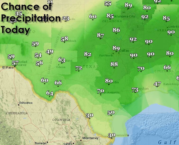
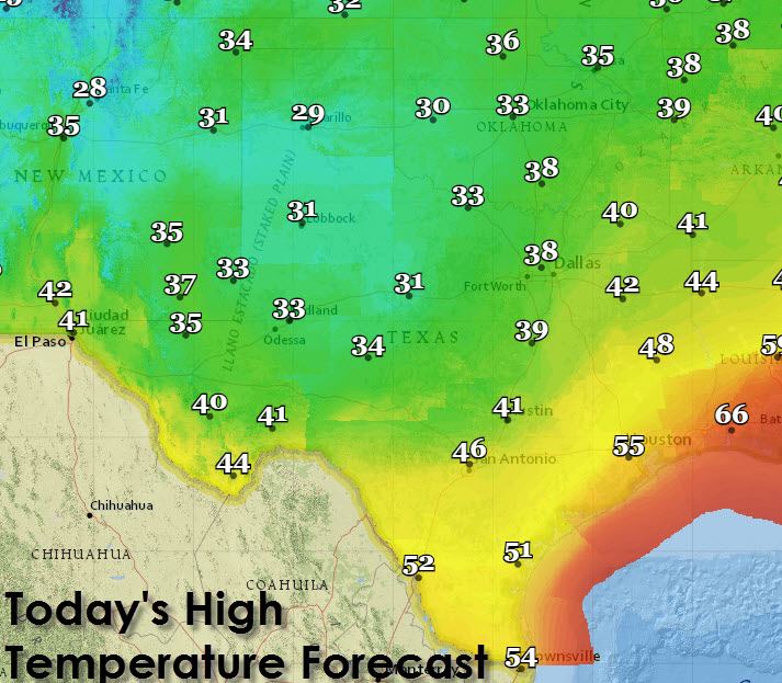
Real quick before I get into the latest winter weather forecast lets talk about today’s high temperature forecast. As you might expect its going to be a cold one across a good chunk of Texas with a winter storm that will continue impacting the western half of our state. Folks in Southeast, South, and the RGV will actually be decently warm today with highs climbing into the 50s. Precipitation chances are likely today across the entire state of Texas with lesser chances in the Rio Grande Valley.
I told folks to keep checking back for forecast refinements last night and true to my word there have been changes this morning. Unfortunately these changes are not the kind we like to see as it means a high-impact winter storm will likely strike today. Confidence in a significant ice storm is increasing for Northwest Texas, the Rolling Plains, and Southwest Oklahoma. We’ve already got freezing rain depositing up to 0.10″ of ice in parts of the Permian Basin and Concho Valley. That precipitation will continue to expand northeastward this morning resulting in a number of impacts across the aforementioned areas. Lets start out by going over the latest winter weather products in effect today through Saturday morning.

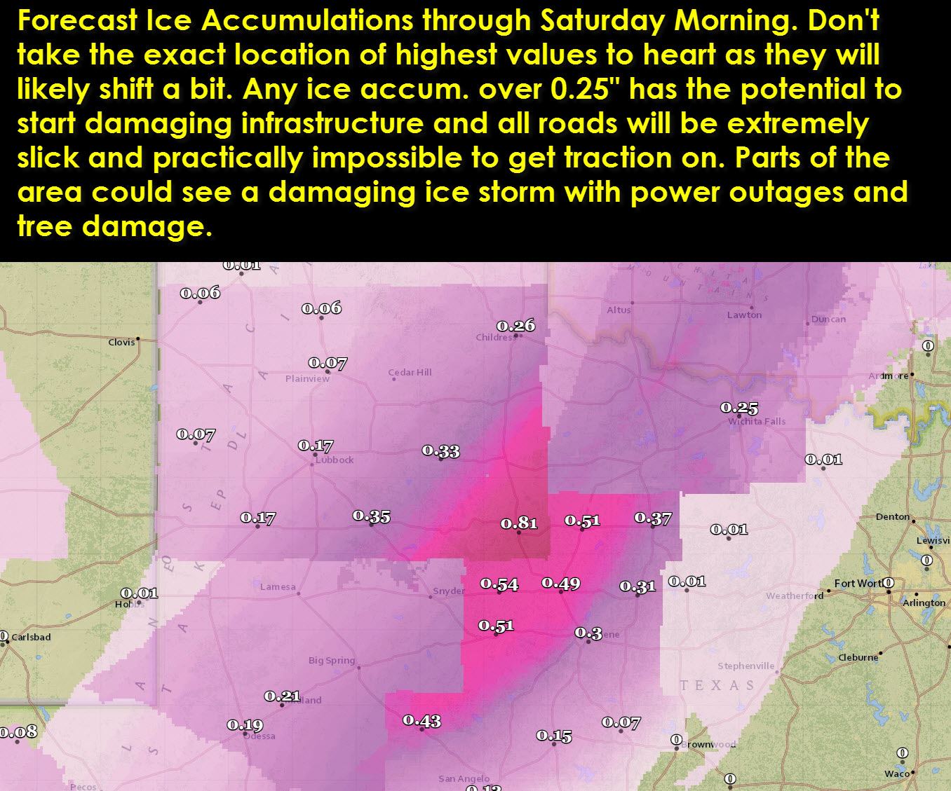
* WINTER STORM WARNING (ICE STORM WARNING) for Northwest Texas, South PLains, Rolling Plains, Permian Basin, and Concho Valley. Wichita Falls, Vernon, Quanah, Childress, Plainview, Lubbock, Big SPring, Midland, Odessa, Pecos, Alpine, San Angelo, and Abilene are a few cities included in this warning. This is where confidence is highest in significant additional accumulation of freezing rain today through tonight. Travel will be nearly impossible and extremely hazardous in these areas and thus I recommend no travel through Saturday if at all possible. Localized power outages and downed tree limbs can be expected in areas that receive over 0.25″ of ice accumulation today.
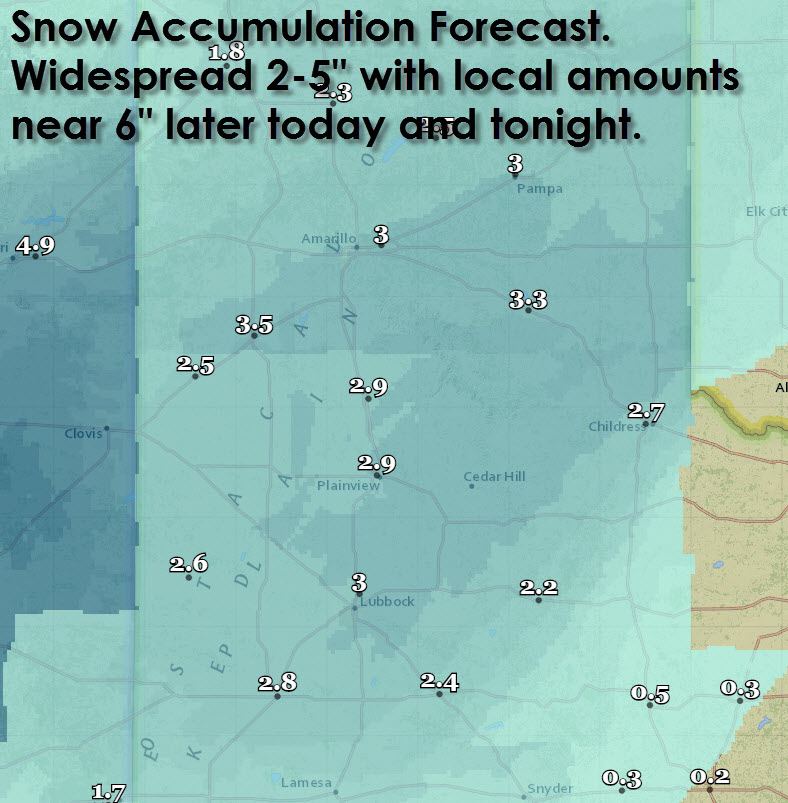
* WINTER WEATHER/TRAVEL ADVISORY is in effect for the Texas Panhandle mainly from this afternoon through Saturday morning. Snow is expected to develop on the back end of the storm system later this afternoon. This snow will move through the Panhandle this evening resulting in 1 to 5 inches of snow accumulation with localized amounts up to 6 inches possible. We’re going to have to watch the southeastern Panhandle closely today as they may end up seeing freezing rain vs. snow which would result in an upgrade to a Winter Storm Warning.
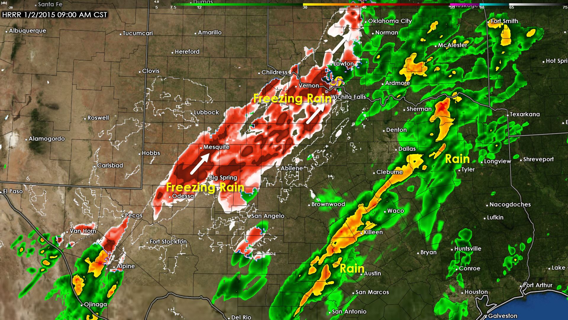
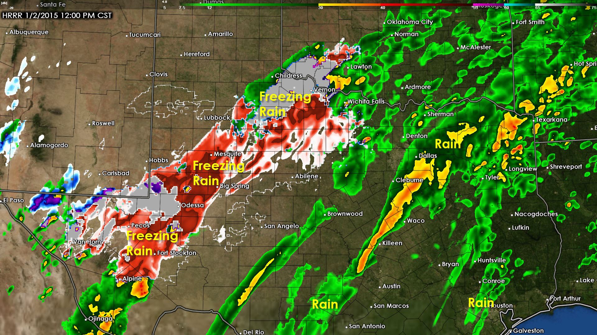
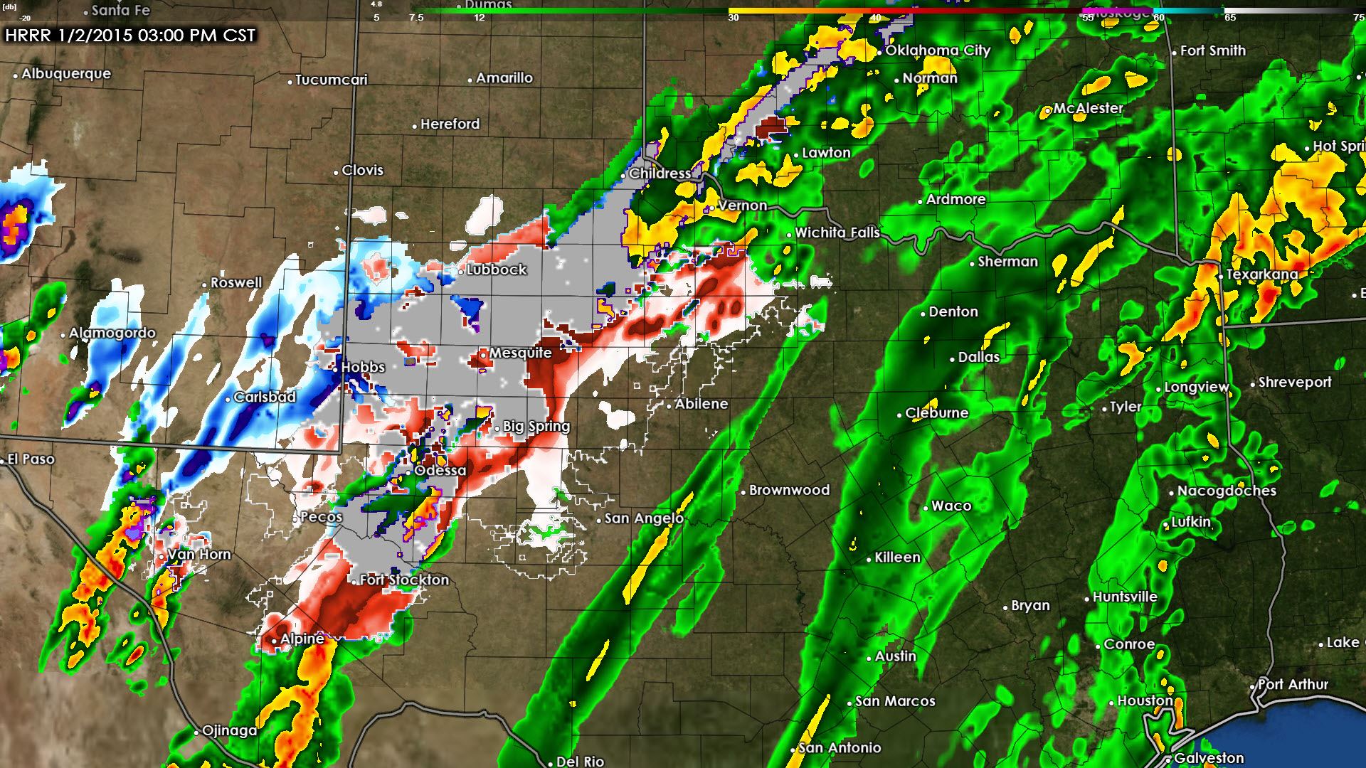
Here’s the latest timeline from the High Resolution Rapid Refresh weather model. I show these images not only to show where the precipitation will liekly be but what type of precipitation will be falling. Temperatures across the eastern half of Texas will be well above freezing and thus no winter weather hazards are expected although its going to be a dreary, wet day. Across the western half of Texas (essentially west of US-281) is where our focus for winter weather will be today. Temperatures will play a critical role in how much accumulates. If temperatures in a spot climb to or above freezing than any ice that had accumulated will start to melt and the precipitation will be simple liquid rain. That’s why we’re going to have to keep an eye on temperatures today. They will likely slowly warm throughout the morning and afternoon which means the freezing line will slowly move northwest. Hence some spots that are going to have issues with ice this morning may climb above freezing this afternoon on the eastern fringes of the winter weather.
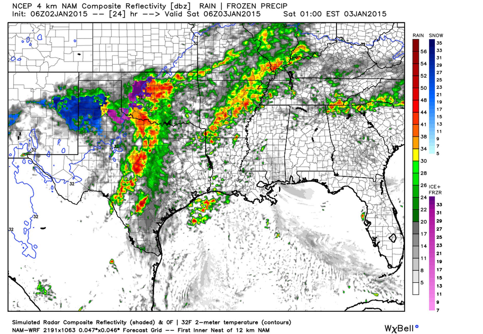
Finally here’s a look from the North American Model at 10 PM this evening and you’ll note we’re still going to have activity ongoing. This is going to be a long-duration event for the western half of Texas and by the end of it I think many roads and interstates will be slick and hazardous.
In terms of accumulations today’s event will be significant and high-impact for the Texas Panhandle, South Plains, Rolling Plains, Permian Basin, Concho Valley, and Northwest Texas. The storm system coming in today is much stronger than the one on New Years Eve and even stronger than we thought it would be even 12 hours ago. For that reason accumulation forecasts have gone up. Even now we’re not completely confident that the accumulation forecast is right on the spot in terms of highest totals or where they may end up. However I must emphasis confidence is now high that parts of the aforementioned region will see a damaging ice storm with possible infrastructure damage (power outages, tree damage, completely impassable or even closed roads).
Remember you can track today’s weather using our free interactive weather radar located at texasstormchasers.com/radar. I’m going to get a few hours of shut-eye so I can be recharged by late morning to handle the winter weather event. Jenny will post a few updates if she has time but seeing she works a full-time job I’m not sure that is going to happen. I’ll have a comprehensive update by early afternoon if Jenny doesn’t have time to get one out this morning.


0 Comments