


Overall confidence in winter weather occuring tomorrow afternoon into Saturday morning remains high. What remains somewhat uncertain is where the heaviest accumulations of snow and freezing rain will fall. The eventual track of an upper level storm system will determine where the heaviest corridor of precipitation sets up. Another complicating factor is warming temperatures which are the result of warm air advection drawing moisture in from our south. That’ll be good for those across North and Central Texas who saw freezing rain earlier today because temperatures this time around will remain above freezing. There will not be any ice issues across the D/FW Metroplex with many of the issues tomorrow related to new precipitation being west of Highway 281.
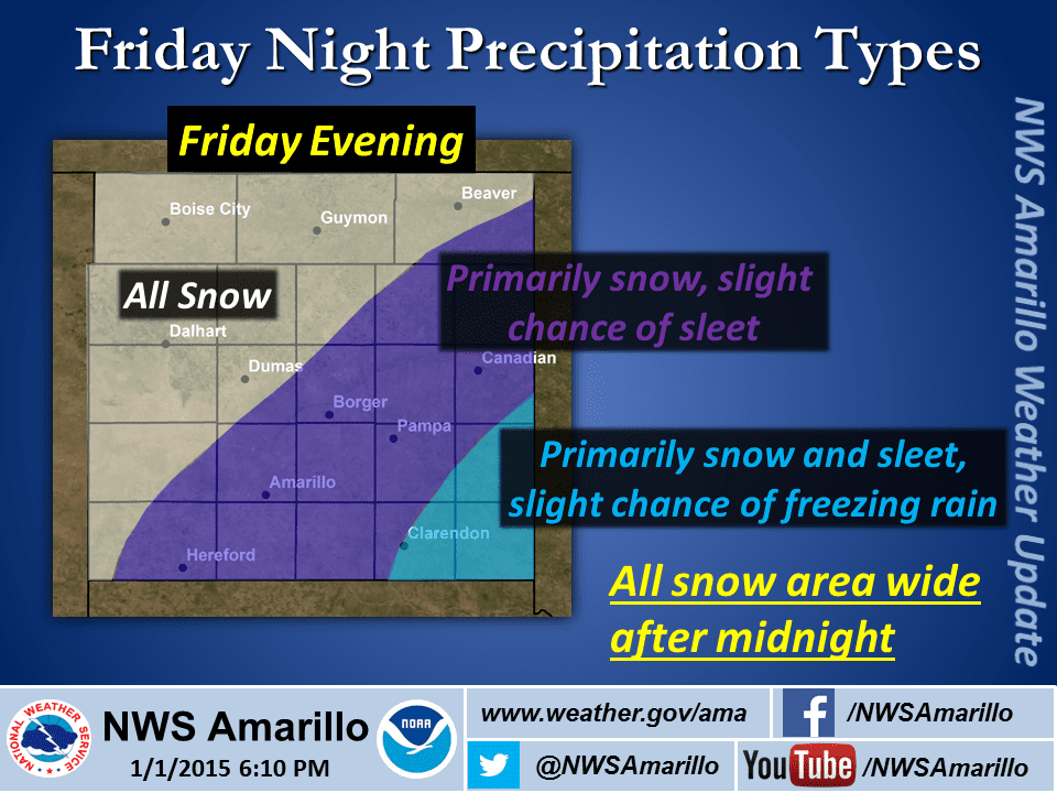
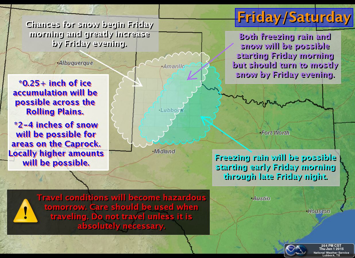
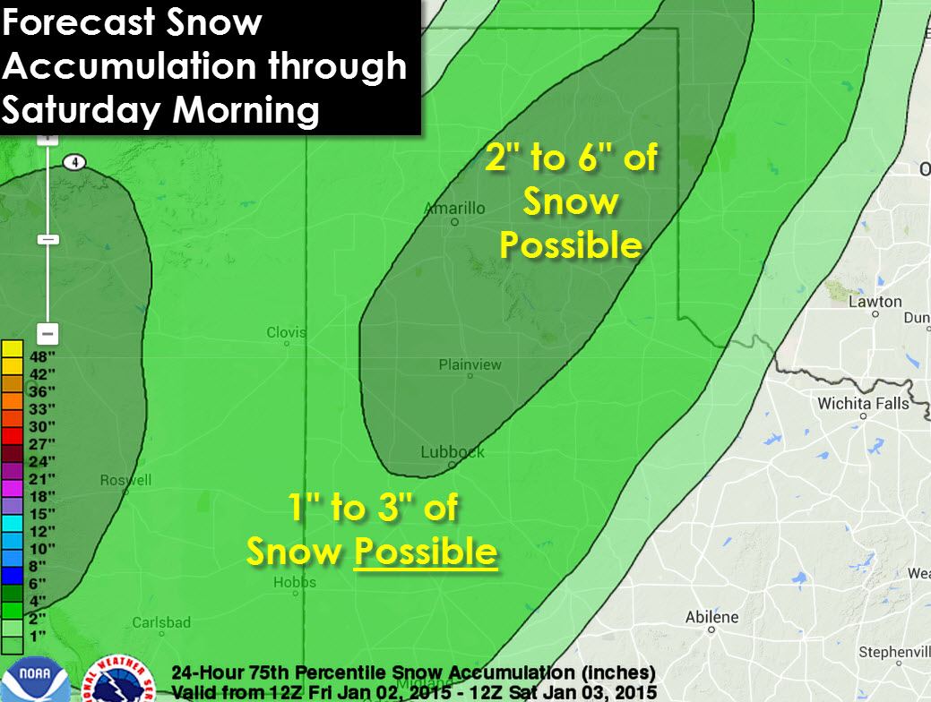
What we do need to worry about is those across the Texas Panhandle, South Plains, Rolling Plains, Northwest Texas, and perhaps even the northern sections of the Permian Basin and Concho Valley. The freezing line will be slowly moving northwest tomorrow but exactly where it ends up is another uncertain factor. We expect snow will be the primary precipitation type in the Panhandle where cold air remains in place across the atmospheric profile. Across the Rolling Plains into the Permian Basin and Northwest Texas warm air advection will cause the primary precipitation type to be freezing rain. Moisture tomorrow will be much more plentiful than today’s system which means overall accumulations have the potential to be much more significant. I do expect that a part of the Panhandle will see an enhanced band of snow that could drop over 6 inches of snow in spots. We won’t be able to determine where that heaviest snow band sets up until we get into the afternoon hours tomorrow and start seeing mesoscale features in the atmosphere.
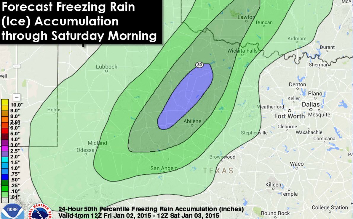
As for the ice potential there is the potential for some locations across the Rolling Plains and Northwest Texas to receive a major ice storm. With such an abundance of moisture in place I do have concerns some locations will see over half an inch of ice accumulation which will not only cripple travel but could cause local power outages. We’ll continue to refine this forecast and post more information tomorrow. This is a forecast that has the potential to change several times between now and tomorrow evening based on all the dynamics coming together that could shift. Regardless I anticipate major travel problems will develop tomorrow evening across the Texas Panhandle, South Plains, Rolling Plains, Permian Basin, and parts of Northwest Texas. Those travel impacts will likely include Interstate 20, Interstate 27, Highway 287, Highway 82, and Interstate 40 just to name a few big roads.

* WINTER STORM WARNING for the Permian Basin and Concho Valley until 12 PM Friday. Alpine, Pecos, Odessa, Midland, Big Spring, Snyder, Throckmorton, Abilene, and San Angelo are a few cities included. Travel remains hazardous across the warned area today as temperatures remain below freezing. Additional freezing rain will occur tonight which will deposit an additional 0.10″ to 0.25″ of ice on top of what has already fallen resulting in continued hazardous driving conditions.
* WINTER WEATHER ADVISORY for all of the Texas Panhandle and Northwest Texas from Friday through Saturday afternoon. Dalhart, Dumas, Spearman, Canadian, Amarillo, Pampa, Shamrock, Quanah, Vernon, Seymour, Wichita Falls, Archer City, and Henrietta are all cities included. Precipitation is expected to begin on Friday as the next piece of upper level energy enters the region. Snow totals of 2 to 4 inches will be possible in the Texas Panhandle with significant ice accumulations up to 0.50″ in Northwest Texas. Hazardous travel conditions will develop and travel will become difficult and dangerous.
* WINTER STORM WATCH for the South Plains and Rolling Plains from Friday Morning through Saturday morning. Muleshoe, Dimmitt, Tulia, Plainview, Lubbock, Brownfield, Post, Spur, Paducah, and Childress are cities included in the watch. Significant accumulations of snow and ice are possible during the second half of Friday into Saturday as our next winter storm pushes into the region. The overall temperature profile will determine exact precipitation types and accumulations. We’ll have time tonight to refine the forecast and nail down the accumulation forecast.


0 Comments