
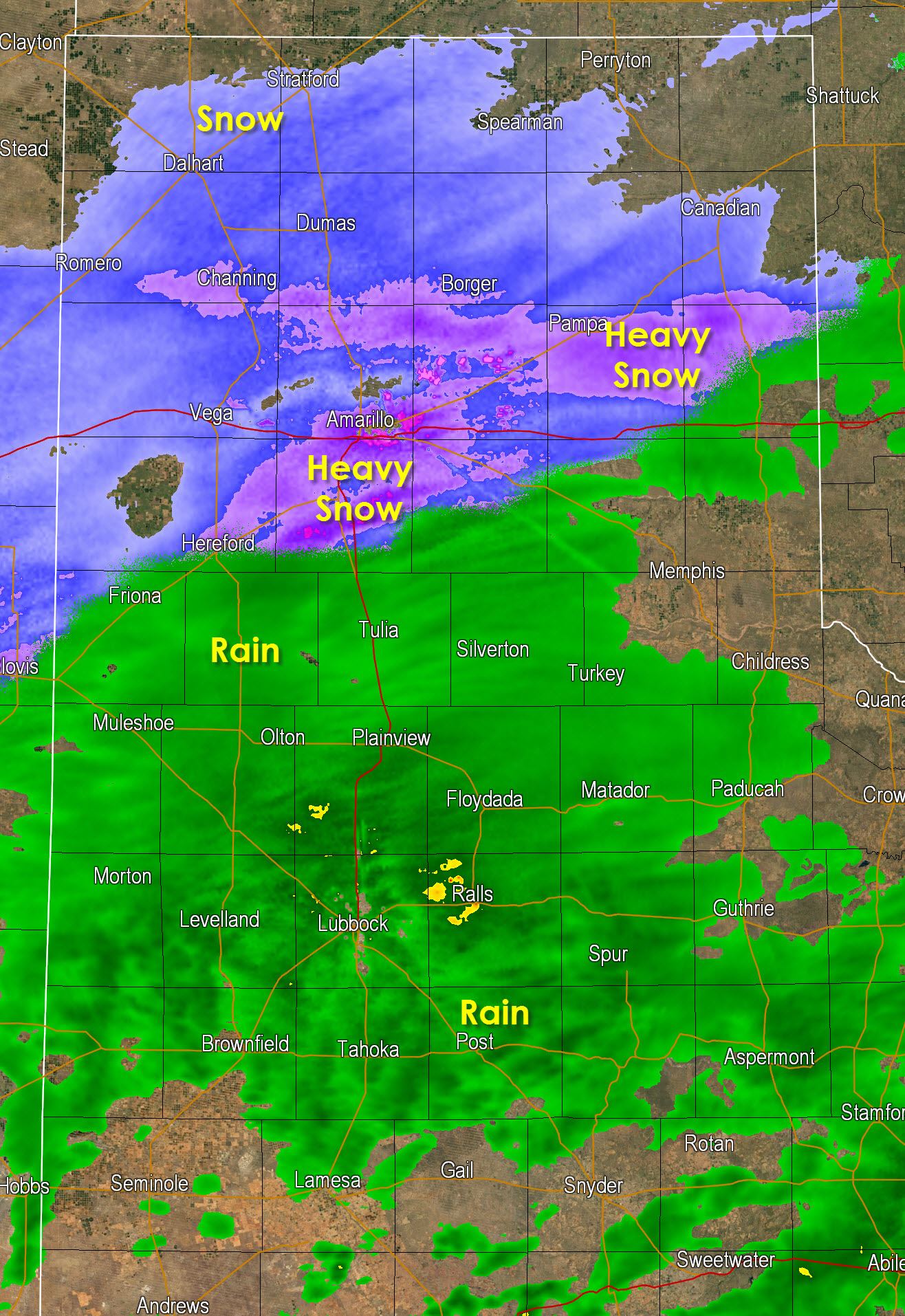
We now have moderate snow falling across the northern half of the Texas Panhandle. Heavy snow is beginning to develop in a band along and just north of Interstate 40 from Amarillo east to Pampa. That lines up well with what the high resolution weather models are showing for the next few hours. We have a report of 6″ of snow in Texline in the extreme Northwest Panhandle with an inch of snow now in Borger. Snow accumulations will increase as snowfall increases this evening in the Panhandle. The rain/snow line will continue to progress south into the southern Panhandle and northern South Plains through 9 PM. It’s worth noting temperatures have fallen to freezing in Amarillo and points north which means roads will start freezing over soon.
A look out the window in Amarillo
Snow now accumulating in downtown #Amarillo. Roads still just wet. #phwx #txwx pic.twitter.com/hQI0CTYO5W
— Brian James (@BrianJamesNBC5) January 22, 2015

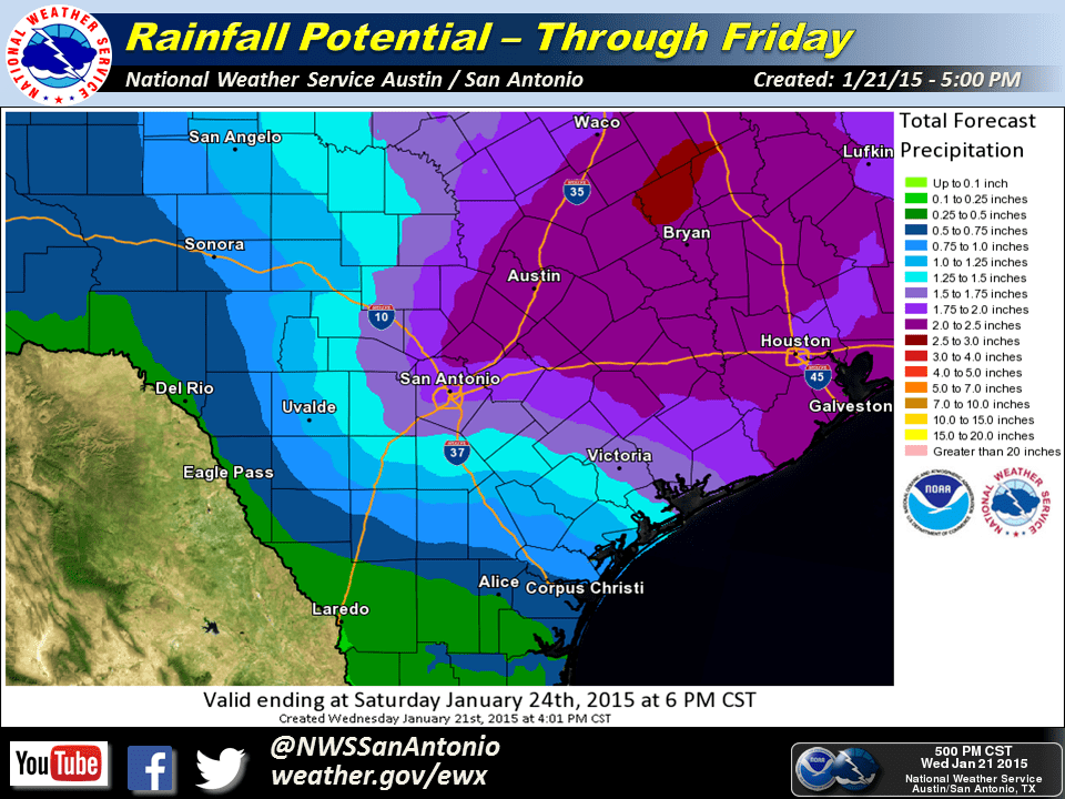
Widespread rain is underway across the South Plains, West-Central Texas, North Texas, Central Texas, South-Central Texas, and now extending into the Brazos Valley and Southeast Texas. All activity is moving northeast and will continue to do so this evening. Additional precipitation should dvelop in South Texas later this evening as upper level forcing increases. We may infact see a few thunderstorms across South-Central and Southeast Texas tonight but no severe weather is expected. Here is the latest rainfall forecast for tonight and on Thursday across South-Central Texas.
_____

A Winter Storm Warning for Heavy Snow is in effect tonight through Thursday evening for most of the Texas Panhandle, South Plains, Trans-Pecos and Davis Mountains including Dalhart, Dumas, Borger, Perryton, Pampa, Amarillo, Hereford, Dimitt, Plainview, Lubbock, Littlefield, Morton, Post, Seminole, Midland, Odessa, Pecos, Van Horn, Fort Stockton, Fort Davis, Marfa, and Alpine. Snow accumulations will vary depending on the location but the western Texas Panhandle could see up to a foot of snow.
A Winter Weather Advisory for Snow in portions of the Permian Basin, West-Central Texas, Northwest Texas, and the eastern Texas Panhandle including Shamrock, Clarendon, Childress, Matador, Guthrie, Vernon, Crowell, Quanah, Wichita Falls, Aspermont, Snyder, Sweetwater, Big Spring, and Big Lake. In addition extreme West Texas including El Paso are also included. Snow accumulations will vary on location but amounts and impacts are expected to be less than the Winter Storm Warning.
A Winter Storm Watch is in effect for a portion of the Concho Valley including Abilene and San Angelo. This will likely be converted to a Winter Weather Advisory later tonight for the chance of light snow accumulations with some travel impacts on elevated surfaces.
A Rain/Snow mix is possible northwest and west of the D/FW Metroplex tonight and THursday morning where minor snow accumulation on grassy surfaces will be possible. Surface temperatures will remain above freezing and travel impacts are not expected in this area. There is a light chance for snow Thursday Night across much of North Texas including the D/FW Metroplex where we may see a dusting to half an inch of snow accumulate on grassy surfaces. No travel impacts are expected at this time. One caveat is if we see a band of heavier snow develop and move over an area for an extended period of time.


0 Comments