
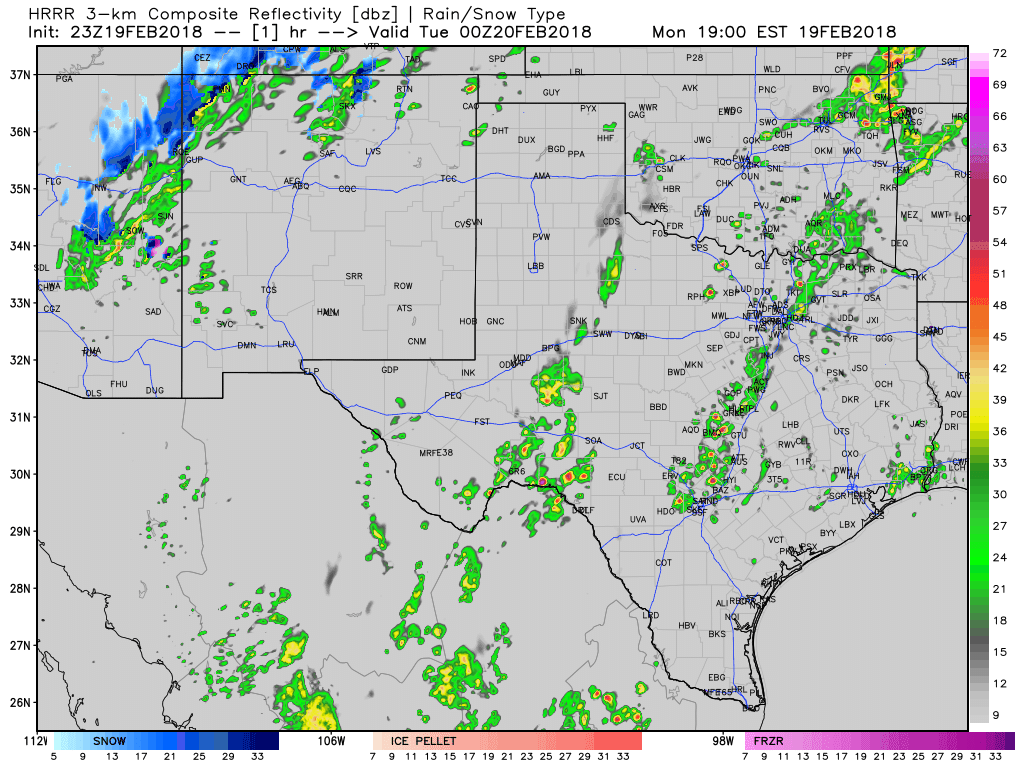
Simulated weather model radar for tonight through Tuesday morning. Times in Eastern on top-right part of the graphic.
A major pattern change began a few days ago and our weather is going to become quite active this week. Thunderstorms, heavy rain, some winter mischief, and even some flooding are hazards we’ll face in the next couple of days. Our focus will be on the next two storm systems. The first will be tonight and on Tuesday. The second will be on the first’s heels and bring impacts on Wednesday and Thursday.
Strong to severe thunderstorm potential tonight
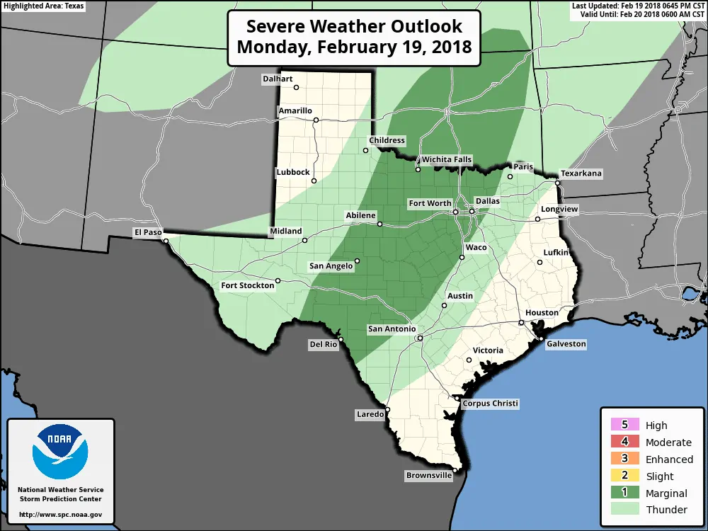
A level one (marginal) risk of severe weather has been issued by the Storm Prediction Center for tonight. This risk includes Northwest Texas, Texoma, the two-thirds of North Texas (Bonham to Terrell to Waco and points west), the Big Country, the Concho Valley, the Edwards Plateau, and the Hill Country. The severe weather outlook uses a five-level rik scale that conveys how widespread the risk of severe weather could be. Level one is at the bottom of the scale – meaning only localized/brief instances of severe weather are expected.
The strongest storms tonight may produce localized wind gusts up to 55 MPH. More intense storms may produce hail up to the size of quarters – although most hail should remain smaller. The threat for tornadoes is non-zero (very, very low). Severe thunderstorms are not expected during the daytime hours on Tuesday.
Rainfall Forecast
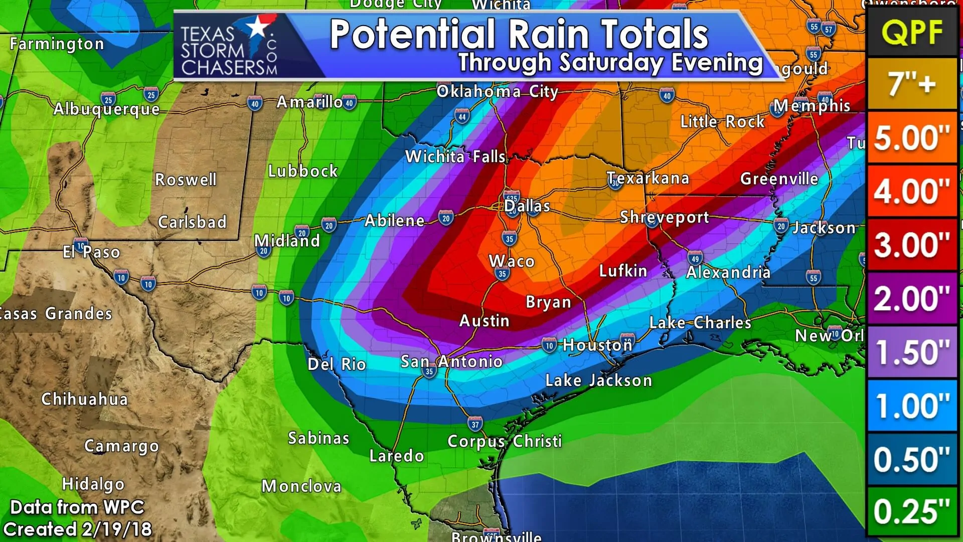
If you’re located east of Highway 281 in Texas you’ve got a good shot at seeing rain this week. At least two storm systems will bring multiple chances of rain over the coming days. Unfourtinietly these systems will not bring much (or anything) to the Texas Panhandle, West Texas, Permian Basin, Borderland, or far South Texas. The Texas Panhandle and West Texas really need rain, but appreciable rainfall just doesn’t look likely this week in those regions.
On the opposite side of the spectrum, those in Northeast Texas and East Texas are going to see too much rain this week. The rainfall forecast posted above is from the Weather Prediction Center (WPC) at the National Weather Service. Don’t expect rainfall amounts to unfold exactly as shown above. There will be local variations and the highest rainfall axis could easily shift north or south. The heaviest rainfall amounts should be located along and just south of a stationary front on Wednesday and Thursday.
The rainfall amounts posted above are forecast over a five day period. A majority of locations will not see all of that rainfall occur in one day.
Flood Potential
There is a moderate risk of flash flooding on Tuesday and Tuesday Night across Northeast Texas and eastern sections of North Texas. A marginal to a slight risk of flash flooding extends south into the Brazos Valley and back west towards the Edwards Plateau.
For Wednesday we currently have a moderate risk of flash flooding across Northeast Texas and East Texas. These forecasts use a similar scale to that used in the severe weather outlooks. A moderate risk is significant and definitely means we could be dealing with flooding. Recent dry weather means that we shouldn’t see widespread flooding through Thursday.
Localized flooding is more probable with ‘training’ thunderstorms. Training storms are those that move over the same locations. They might look like they’re not moving at all on the radar. These situations can produce excessive rainfall amounts in a short period of time. Those who have followed us for a while understand what training storms look like and how they can cause nasty problems over localized areas.
Flood watches have been hoisted for eastern North Texas and Northeast Texas. Those two regions are where the highest threat of localized flooding looks to set up through mid-week.
Winter Weather Potential
This aspect of the forecast is extremely uncertain at this time. A shallow arctic airmass will be in place across Northwest Texas and North Texas on Wednesday into Wednesday Night. Warmer air aloft will be present with warmer air at the surface slowly moving north. There will be precipitation ongoing during that transition. If a shallow-layer of sub-freezing air is in place during precipitation we could have some problems with freezing rain. A big complication to any forecast is that warmer air will be moving in. Even if we did see freezing rain/sleet in one location we’d probably see a transition over to rain as temperatures rise above freezing. Check back on Tuesday for updates since we may end up having a wintery mess to deal with.


0 Comments