
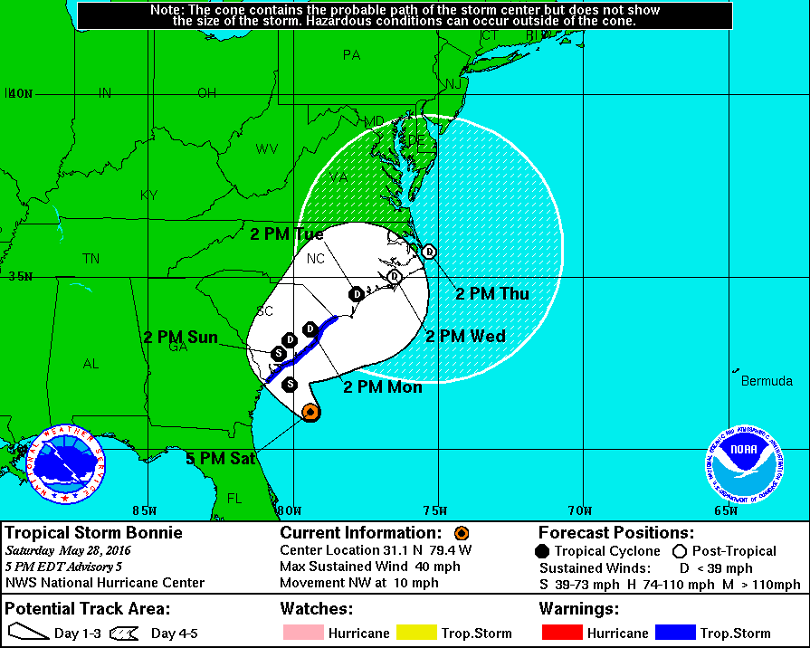
Tropical Depression #2 has strengthened into Tropical Storm Bonnie – the second tropical cyclone of the 2016 Atlantic Hurricane Season. Bonnie now has maximum sustained winds of 40 MPH with higher wind gusts. The 4 PM CT advisory places the center of Tropical Storm Bonnie 120 miles southeast of Beaufort or 125 miles south/southeast of Charleston. The system is moving northwest at 10 MPH and will approach the South Carolina coast late tonight. Now that Bonnie is moving over warm Gulf Stream waters it is possible for some more minor intensification before landfall occurs late tonight. The highest impacts along the coast will be from gusty winds, minor storm surge of 2 feet above normal tide levels, and high surf and rip-currents. Minor flooding and an isolated tornado could occur just inland. Once Bonnie makes landfall late tonight it’ll start to turn north and eventually northeast – eventually moving back offshore.
TROPICAL STORM BONNIE ADVISORY NUMBER 5
NWS NATIONAL HURRICANE CENTER MIAMI FL AL022016
500 PM EDT SAT MAY 28 2016
…DEPRESSION STRENGTHENS INTO TROPICAL STORM BONNIE…
…LOCALLY HEAVY RAINFALL SPREADING ACROSS COASTAL AREAS OF SOUTH
CAROLINA…
SUMMARY OF 500 PM EDT…2100 UTC…INFORMATION
———————————————-
LOCATION…31.1N 79.4W
ABOUT 120 MI…190 KM SE OF BEAUFORT SOUTH CAROLINA
ABOUT 125 MI…195 KM SSE OF CHARLESTON SOUTH CAROLINA
MAXIMUM SUSTAINED WINDS…40 MPH…65 KM/H
PRESENT MOVEMENT…NW OR 320 DEGREES AT 10 MPH…17 KM/H
MINIMUM CENTRAL PRESSURE…1008 MB…29.77 INCHES
WATCHES AND WARNINGS
——————–
CHANGES WITH THIS ADVISORY:
None.
SUMMARY OF WATCHES AND WARNINGS IN EFFECT:
A Tropical Storm Warning is in effect for…
* Savannah River to Little River Inlet South Carolina
A Tropical Storm Warning means that tropical storm conditions are
expected somewhere within the warning area, in this case within the
next 12 hours.
For storm information specific to your area, including possible
inland watches and warnings, please monitor products issued by your
local National Weather Service forecast office.
DISCUSSION AND 48-HOUR OUTLOOK
——————————
At 500 PM EDT (2100 UTC), the center of Tropical Storm Bonnie was
located by satellite and NOAA Doppler radars near latitude 31.1
North, longitude 79.4 West. Bonnie is moving toward the northwest
near 10 mph (17 km/h). This general motion, accompanied by a
decrease in forward speed, is expected through this evening and on
Sunday as the system nears the coast within the warning area.
Maximum sustained winds have increased to near 40 mph (65 km/h) with
higher gusts. Some additional strengthening is possible tonight as
Bonnie moves over the warm waters of the Gulf Stream. Gradual
weakening is forecast on Sunday.
Tropical-storm-force winds extend outward up to 60 miles (95 km)
from the center, mainly to the northwest of the center.
The estimated minimum central pressure is 1008 mb (29.77 inches).
HAZARDS AFFECTING LAND
———————-
WIND: Tropical storm conditions are expected to first reach the
coast within the warning area later tonight or early Sunday.
RAINFALL: Bonnie is expected to produce total rainfall accumulations
of 1 to 3 inches with maximum totals of 5 inches from eastern
South Carolina through southeastern North Carolina.
STORM SURGE: Storm surge inundation of 1 to 2 feet above ground
level is possible within the tropical storm warning area during the
next high tide on Sunday morning.
SURF: Bonnie is expected to produce life-threatening surf and
rip current conditions along portions of the southeastern United
States coast through the weekend. Please consult products from your
local weather office.
TORNADOES: An isolated tornado or two will be possible late tonight
and early Sunday over the immediate coastal region from central
South Carolina through southern North Carolina.
NEXT ADVISORY
————-
Next intermediate advisory at 800 PM EDT.
Next complete advisory at 1100 PM EDT.


0 Comments